
(Image: Tryon Creek Cove Trail Master Plan, Metro)
An ordinance in front of Portland City Council this week will hasten implementation of a plan that will improve the biking and walking connection between Tryon Creek State Park and Foothills Park in Lake Oswego and build a new bridge over Tryon Creek adjacent to the Willamette River.

The City of Portland Bureau of Environmental Services is set to formally adopt the Tryon Creek Cove Trail Master Plan which was completed in March and formally adopted by Lake Oswego City Council last month.
The plan (PDF) considered two options for how to get people across Highway 43 near the intersection with Terwilliger Blvd: a full traffic signal or a tunnel. A third option, which would keep path users on the highway and direct them a half-mile south to cross using an existing traffic signal at Foothills Road, was kept on the table, as a “possible interim solution if other options were found to be infeasible or were long delayed.”
The project advisory committee chose the third option.

Advertisement
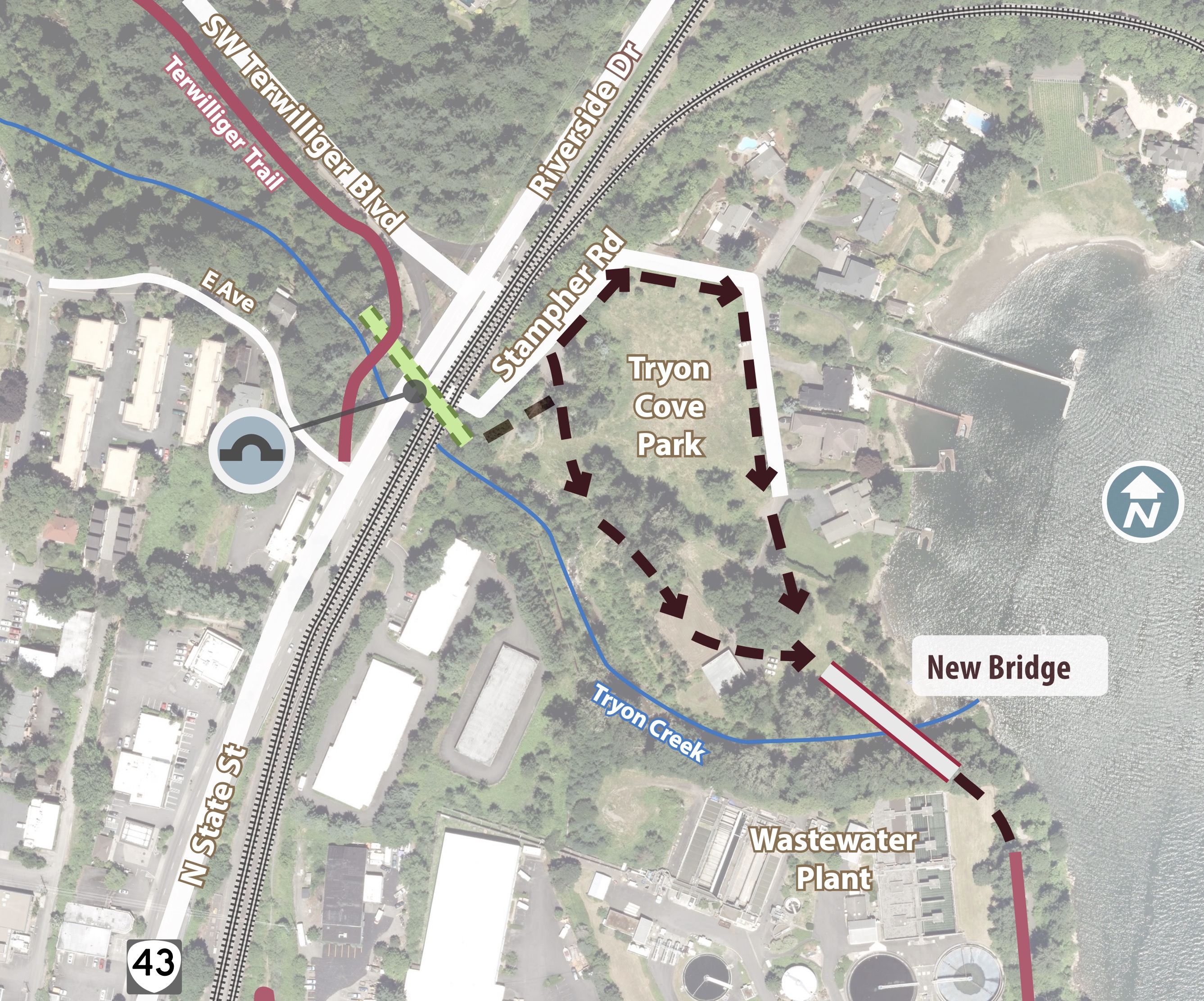
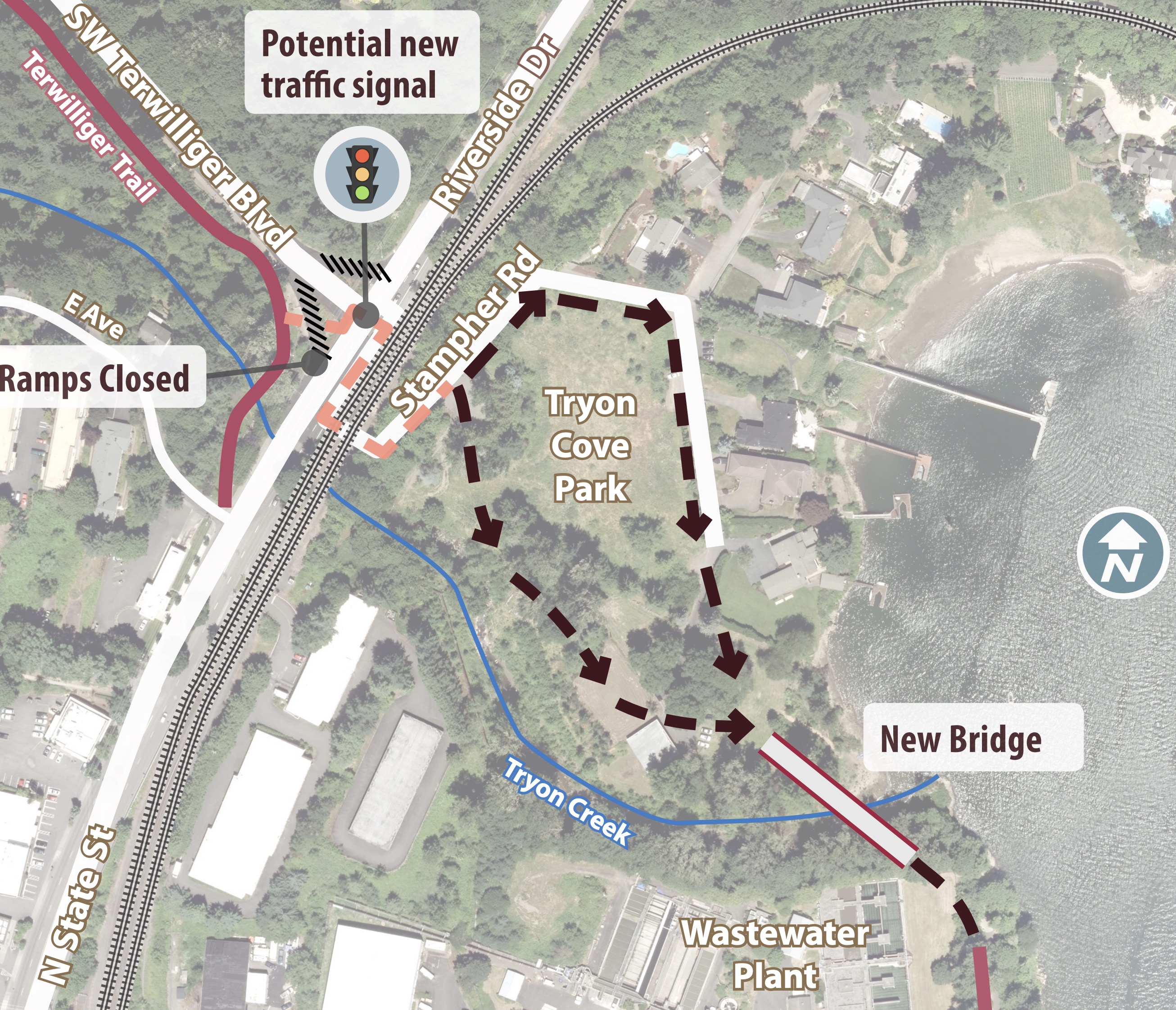

In their recommendation later dated March 26th, 2019 (PDF), the committee wrote, “At this time, the recommendation is to not cross Hwy. 43 with the trail due to approval by Oregon Department of Transportation and Union Pacific Railroad, potential right-of-way acquisition needs, complexity of permits, the need to widen the highway on the north side of Terwilliger Blvd., and high costs ($8-$13 million).”
Instead of a new signal or tunnel that would make a direct connection between the two existing parks and paths, the committee recommended a phased approach (see below). The cost estimate of this recommended approach is about $1.5 million which includes a prefabricated steel bridge over the creek and a 3-4 foot wide soft surface trail (“nature pathway”) in the cove. The narrow trail is considered an interim step. If/when the tunnel or signal option is implemented, a 10-12 foot multi-use path would be installed in its place.
Here’s the recommended alternative showing the on-highway route:

This project takes on added significance given the Oak Grove-Lake Oswego Bridge project. This planned bridge (which we covered in February 2018) would create a carfree connection between the two cities and would likely connect directly to new paths in Tryon Cove Park. Clackamas County is currently leading a a Metro-funded, $306,000 planning study to further develop the project. The study is expected to be completed by November of this year.
— Jonathan Maus: (503) 706-8804, @jonathan_maus on Twitter and jonathan@bikeportland.org
Never miss a story. Sign-up for the daily BP Headlines email.
BikePortland needs your support.


The bridge looks amazing, but will it just dump cyclists at the foot of that terrible intersection of Hwy 43 and Terwilliger – with the right-turn slip lane? Seems like cars really fly thru that intersection. Add bikes to it and you have a recipe for getting someone killed. I’d like to see a cycling-ped bridge that flies over Hwy 43 and joins with this new infrastructure. Do it right. Crazy to say that a $1.1M bridge is a half-measure, but it does seem like one.
This is so very disappointing. I mean the bridge and the connection are NOT disappointing, but clearly the people who chose option 3 have NEVER ridden on Hwy 43 between Terwilliger and Foothills Road, either by themselves, in a group ride, OR with their teenaged, bike-savvy children (https://bikeportland.org/2017/07/03/gaps-233414). It’s not good enough to build great stand-alone bike/ped infrastructure if you can’t get there via bike/ped in a way that won’t get you run over by a truck or car being driven far too fast and aggressively. I’d never in a million years get my mom to ride this alternate route with me, even though she would LOVE the new bridge and connections between the parks.
They should hold off on this until they can either build a signal or a tunnel/bridge over 43. The alternative is ridiculous.
There is no point in building this new bridge if they are not going to address crossing Hwy43 at all. Option 3 is basically meaningless in making this area better in any substantial way. Existing users will just keep doing what they’ve always done and potential new users will continue to avoid it due to how intimidating it is. Pointless. Fix downtown LO to Terwilliger first THEN look at park connectivity. Safety & Transportation > Dead End Path.
As someone who routinely has to get from McVey to Terwilliger to get on the Tryon Creek trail, I’d welcome something official on State Street, but if it’s just paint, it won’t be useful for any but strong, confident riders. Traffic is dangerously distracted and inattentive.
Riding south on State street really sucks. There is no shoulder and though the speed limit is 30, drivers seem to want to go 45+mph here. This is made even worse by the fact that state street is uphill in this direction and it’s hard to get any significant amount of speed. Every time I ride this there is about a 1 in 2 chance that I will be the victim of some aggression from drivers. Sadly there is literally no other way to get to downtown Lake Oswego. Can’t imagine what the committee was thinking here
Seriously?! They’re spending $1M building a bridge between 2 parks instead of fixing the Hwy 43 problem??
I live in West Linn and commute to Portland daily through this area. Personally, I’d never use what is being proposed and will stick to taking the lane on State street through Lake Oswego. IMO, the real key to opening this entire area…. KILL THE TROLLEY, KILL IT DEAD!!! It’s blocking a hugely valuable transportation link for only weekend use, and then only for part of the year? OMG! Take the existing path (rail line) and create a multi-use path between Moody Ave in South Waterfront all the way to Tryon Creek Cove in Lake Oswego. You’d never have to cross the highway… From there, once the new bridge goes in, you’ve practically got a kid friendly route to Mary S Young in West Linn, via Old River Road… This is such low hanging fruit it’s just baffling! My only guess is it’s Dunthorpe dollars keeping the trolley line stretch exclusively for the wealthy, and Clackamas County living in the 50’s…
The easement only exists as rail. If the tracks are pulled out, the land will go back to private property.
Chris, are you sure that’s correct? What about rail banking – keeping a rail corridor intact and using it as a trail so that it could be used as a rail line again in the glorious unknown future ? That’s how many trails have come to be. Wouldn’t it apply here, as well?
is there space along the rail line to ride a bike?
Some of the trolley right-of-way gets to as narrow as about 17 feet according to a Multnomah County document. There is also a tunnel.
The Lake Oswego Petanque Club will just be so delighted.
Why is this at Portland City Council? Isn’t this area part of Lake Oswego? Also this plan is weak sauce as mentioned by everyone else.
Because the City of Portland owns some of the easements required for the project and they two cities will need to sign an intergovernmental agreement (IGA) and work together to make it happen.
A button activated flashing beacon would work instead of a full traffic light when crossing HWY 43. This is where cars are accelerating from 25 to 45mph going north out of LO.
For now, spend or bank the money for bike improvements on State Street. Wait for the study on the Oak Grove LO bridge crossing before committing to this plan. Could be modified and incorporated into into the Willamette River crossing.
Of course holy hell is raised when car drivers ever have to do a 1/2 mile detour, but hey if we’re talking about pedestrians 1/2 mile is no big deal? I mean, it should only take an extra minute or two to cover the extra distance, amirite?