

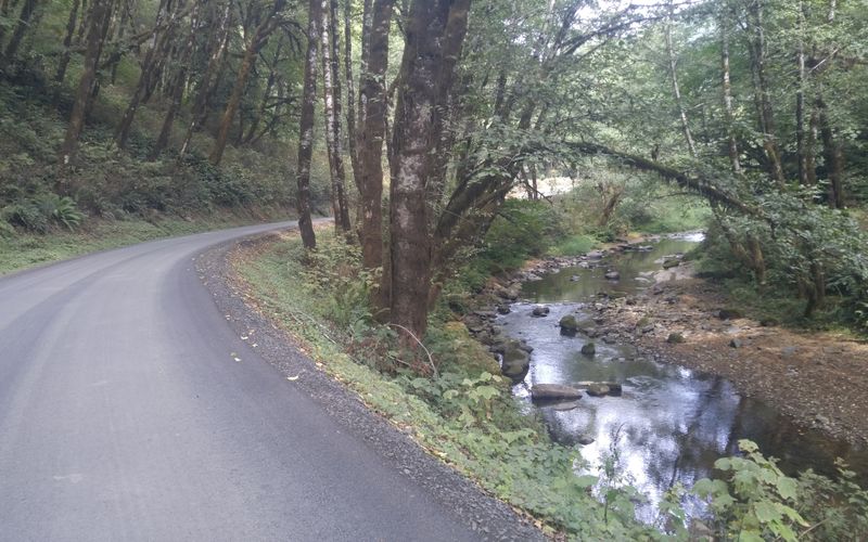

*Scenes from a reconnaissance ride on the route taken by Benjamin Colwill.
Many of you are familiar with the famous (or infamous, depending on your experiences) Oregon Coast Bike Route.
Can you imagine doing the entire thing — from Astoria to Brookings — but instead of rolling along the paved coastal highways, you’d be riding in the coast mountain range? Off-road?! That’s the promise of a new event known as the Oregon Emerald Outback.
At 600 miles and about 65,000 feet of elevation gain, it’s an audacious proposal.
I connected with the OEO’s creator, Benjamin Colwill, to learn more about him and the inspiration behind the event.

Tell us a little about your background:
I was born and raised in Portland, Oregon and since my 20s, I’ve lived all over the northwest. I picked up bikepacking in 2010 and rode my bicycle all around the country touring for six years. I haven’t driven a vehicle since then. I currently spend my winters in Arizona mining for gold and occasionally riding in 70 degree weather.
How did you get into doing these “ultra” rides?
I bumped into some TransAm racers the first year they took off and talked to a few of them along route in Prairie City. From then on, I had my mind set on racing the TransAm and started my ultra-light, ultra-cycling career. I raced the TransAm in 2016 and finished 5th and then again in 2017 and I took the lead after 500 miles — only to lose it and have to drop out after an achilles tear about a thousand miles later.
I raced the Steens-Mazama 1000 the next month and finished 2nd behind Kraig Pauli and then raced it again in 2018 finishing first and setting a new course record.

How’d the Oregon Emerald Outback come about?
After those races, I wanted to focus on rides I want to do, ones on backroads with gravel and dirt. I started the Santa Fe Trail Race in 2018 and when I got back from a test spin from the course, I realized Oregon had a lot to offer for backroads — especially along the coastline.
So I set up a route on RideWithGPS (a Portland-based route creation, event-planning, and mapping tool) and took off. I immediately fell in love with the non-motorized use roads the Oregon coastal Mountain ranges have to offer. Roads covered in pine needles with a layer of moss. I mean, come on! It was too serene: Dense vegetation among woodsy growth with ample opportunities to collect water from streams. What could be better?
How many people will join you on May 4th in Astoria for the inaugural ride?
The amount of people is still unknown for the 2019 ride. I like to keep these rides open to all who seek an adventure. Yes, it’s a race and you should stay true to the course; but I also like to see people use this as a bikepacking event where they can sluggishly join in too, no matter what battle they’re fighting. This is an event for all to enjoy.
Advertisement
The route goes through some rugged and remote places. Are you taking safety precautions?
SPOT trackers are required and offer a little bit more safety to the event. There will be a live map with all the riders’ locations tracked by Trackleaders. The SPOT Gen 3 tracker has an emergency S-O-S button for riders who get in trouble and need to get carried away. Emergency use only of course! They will not come to fix your flat tire.
How long will the entire route take to complete?
600 miles and nearly 65,000 feet of elevation gain is a lot. You’re climbing over a 1,000 ft every 10 miles. I would venture to guess it will take in the three day range for our top riders — and that’s one hell of a push. There is some steep terrain that is going to take maximum effort. And a rouge lantern [back of the pack] time could be around two weeks.
I’ve ridden about 200 miles of the route and from what I’ve seen, it can be a physical challenge to the extreme. You add elements such as rain, and you have even more.
In true ride organizer fashion, Colwill tells us he plans to finish riding the remaining 400 miles of the course in March to vet the route and make changes if needed. As everyone who’s ridden in the coast range knows, you can never count on the existence of a road or trail until you see it with your own eyes.
Good luck Benjamin (and everyone else lucky enough to try this)! We can’t wait to hear how it goes.
If you’d like to sign up, see more photos, or take a closer look at the route, visit OregonEmeraldOutback.com.
— Jonathan Maus: (503) 706-8804, @jonathan_maus on Twitter and jonathan@bikeportland.org
Never miss a story. Sign-up for the daily BP Headlines email.
BikePortland needs your support.


That sounds very hard. I appreciate Benjamin’s infectious enthusiasm and commitment to public access!
thanks for the interview.
I’m not into the racing aspect, even though it’s a slow-as-you-want-to type race, but the route sounds amazing. I’ll take a steep gravelly climb in a quiet forest over a noisy RV filled flat highway any day.
I also look forward to seeing the route come into form, including some reviews of the “best” parts (fingers crossed the whole thing is great). I bet you could make a pretty rad week loop out of Portland doing the northern 1/3 of it.
Sounds incredible.
For those of us without GPS is there a map option?
He’s using RWGPS so yes, there’s your map, however, to attempt a ride like this with only a map would be foolhardy. If you don’t own a GPS I think there’s at least one if not two places in Portland that rent them.
If you have a smart phone and download the map to an app for offline use(ie Ride with GPS)…there’s your GPS. Plenty of info around on how to do this on the RWGPS site. But yes to do these rides with just a map would be difficult unless you are an ace with dead reckoning and topo examination etc.
If you’re running iOS there is an app called MAPOUT. almost zero battery draw. you download Topo squares for the areas you’ll be riding and can add GPS routes to them. The app does NOT give turn by turn directions, but is an incredibly detailed and accurate map that shows your location and where your route. It is honestly the best of both worlds with almost no battery use and it is accurate even without phone signal. I’ve used it all over the world. It is very easy to treat as a paper map. At this point it is the only thing keeping me in the apple ecosystem – it is that good. it isn’t free, but it is very reasonable. CHECK IT OUT!!
I’ve been using an app called GAIA GPS which sounds quite similar. I have used it a bit in the wilderness, but more so on international trips. One of the really cool features is the ability to download different types of maps based on what you are needing for the adventure.
Also Avenza maps.
Having long fantasized about off-pavement routes crossing Oregon in various directions, since long before the Oregon Timber Trail, I’m very excited out this. As a slow rider and even slower climber I have zero interest in this route as a race. As a tour, though …. now that sounds nice.
I’m what passes for the local expert on the area from Stage Coach Road, (where I used to live and bike commute to and from Eugene) to the hwy 38 stretch. I guess it’s different strokes for different folks, but some of his selections leave me thinking this route isn’t quite ready for prime time. Why do N. Sister instead of staying on the M-line to S. Sister and then on to Gunter-Alma? Both are in the “interesting” category of often-abandoned (read: you’ll carry your bike over downed trees), but Gunter-Alma involves more gravel/less pavement. Why not go over Roman Nose? After all, it’s right there. Yes, it’s paved most of the way, but that’s apparently not a deal breaker. Personally, I live the really steep part at the beginning of the climb up to Roman Nose, especially on a tandem. It’s always been one of my favorite climbs and has the added bonus of actual cell phone reception just before the top.
Ah well, there’s no perfect route, just lots of the best riding on the continent. It looks like lots of fun with just a handful of problematic highway connections. (I never, ever ride on any portion of hwy 38. YMMV, but I used to drive trucks that way and the motorists just aren’t civilized.)
If it was a tour through old growth forests, maybe. But twisty, steep, up and down climbing through endless clearcuts, tree farms and logging operations? Also, you will need to heed the kind of people who live here. Hill folk with all the stereotype that goes with them.
“hill folk” ? Come on “city boy” you can do better with all your bike hipster stereotypes…Not helping bridge any divides between our community of cyclists and those that don’t or choose to live differently/elsewhere with comments like that. It’s your prerogative and right to make those comments, but mine as well to comment on them. As far as the route and this type of riding, it isn’t for everyone and can be with its’ own set of hazards and issues…but don’t the safe “bike paths” we have here in the cities have some of those same issues? Ride or don’t but we should celebrate all of this riding and the differences that make up our cycling community.
I’ve pretty much given up road riding except for quiet neighborhood streets (greenways) and bike paths . I switched to gravel after doing the Oregon Outback in 2014. Along the route I was offered water, food, free camping and mechanical assistance by “hill people”. They tended to slow down when Passing and the majority waved back when I waved. This has continued to be my experience on other gravel routes. I’ll take these country folks over Portland drivers any day of the week.
Touring in “hill people” country I get see a 90% wave rate from pick-up truck drivers. The rate for car drivers is lower, so I suspect more of the car drivers are from the city. When was the last time someone stopped to offer you a fresh peach in Portland?
One of the great things about bike touring is how it breaks down the ego destroys your stereo-types of the world. Some people just need to get out more.
I’ve had far more good experiences with “hill folk” than people in this city which has gotten meaner by the day.
I have experienced the “rolling thunder” diesel pickup phenomenon but that was on rural paved roads (higher speed limit) closer to town. I do find the further from town/city and the rougher the road, the friendlier the people. This has been my experience and I don’t mean to discount bad interchanges others may have experienced.
This is an impressive route, I have no interest in racing it, but I sure hope the organizer has a chance to ride the complete route. The coast range is no place to assume the maps are correct or the roads passable in anyway, only way to do that is with tires on the ground.
Has anyone had the experience of using RideWithGPS for routefinding and being unable to hear the audio cues? I’m thinking a small Bluetooth speaker on the handlebars might be the answer – anyone tried something like that for longer rides? I’m wondering about battery life and audibility.
This sounds amazing. I wish I was ready to tackle something like this. This would be a great goal for the future.
At age 73 you can count me out. Looks fun over a month, though.
FFS, pine needles come from pine trees, which are 8n short supply in the OR coastal range. Those are Doug fir and hemlock needles.