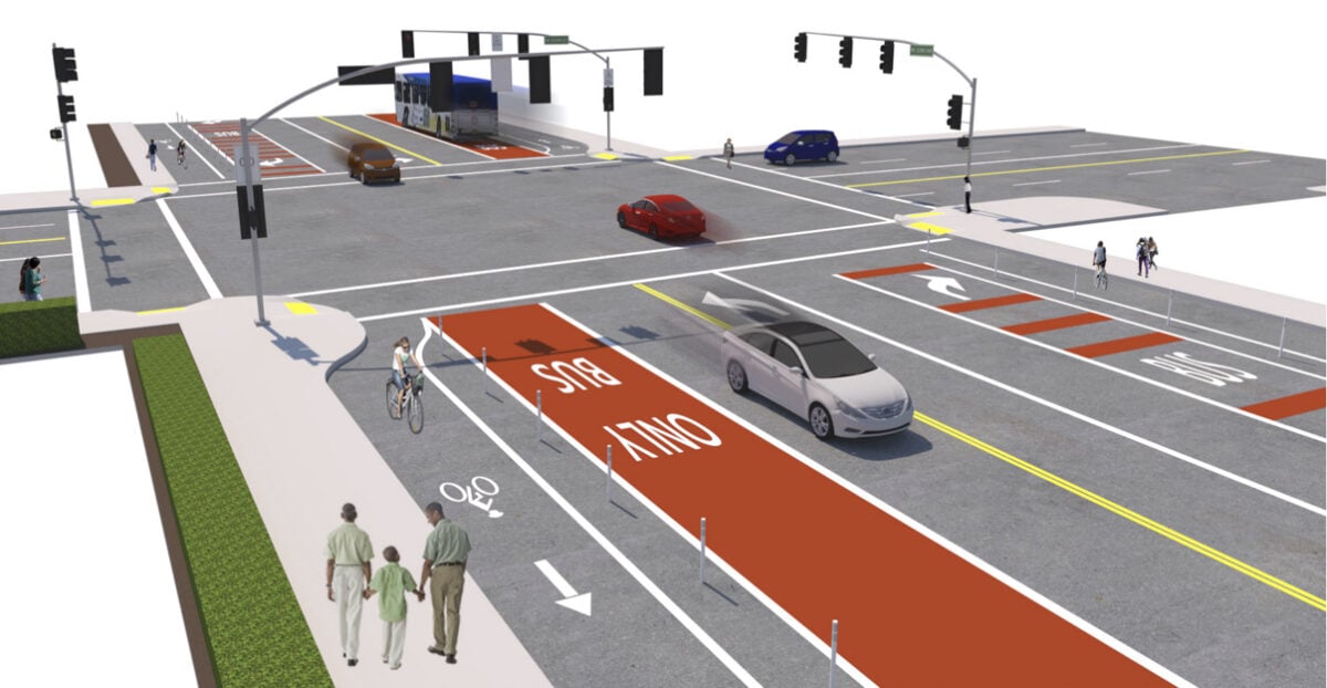
A new program from the Portland Bureau of Transportation has quietly emerged as the agency’s latest attempt to make progress on our deadliest streets.
I stumbled across the East Portland Arterial Streets Strategy (EPASS) while on PBOT’s website a few weeks ago and have now learned a bit more about what we can expect from it.
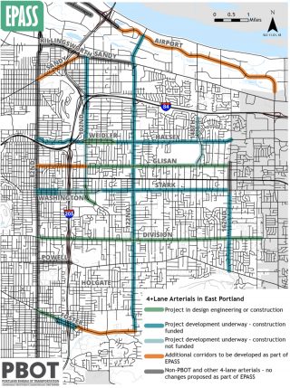
Here’s the background: PBOT has significant plans and funding ($255 million allocated to the East Portland in Motion plan) devoted to taming east Portland arterials. But progress is painfully slow. 15 of the 32 people who’ve died in traffic crashes so far this year were using streets east of 82nd Avenue.
In an effort to consolidate and hasten the 15 projects currently in progress or in the pipeline — and do a better job communicating changes to residents and business owners — PBOT says they plan to develop a concept design for every city street with four or more lanes east of 82nd Avenue. The designs will answer questions about how many driving lanes a street should have, what type of bike lanes, transit lanes, and medians are appropriate, how best to manage curb cuts, turning movements, and so on. The designs will be based on community input, safety analysis and traffic modeling.
According to PBOT, they created EPASS to answer concerns they’ve heard from east Portland residents about how planned projects will impact surrounding streets. Fears that road diets will lead to more cut-through traffic in neighborhoods is a very common concern. Asked about the impetus for EPASS, a PBOT spokesperson told us, “If we’re reducing lanes on multiple streets in the same area, can we do that without delay and diversion onto other streets that would impact the community?”
Advertisement
One of PBOT’s challenges in their work east of 82nd is that they’re re-allocating road space on arterials and simultaneously trying to develop “low-stress, family-friendly” neighborhood greenways that meet their standards for auto traffic volumes.
This is also a public relations move that will aid PBOT’s communications strategy. The agency says they want to take a, “more holistic look at the package of projects coming to east Portland and provide the community with a more comprehensive picture of the improvements and impacts coming their way.”
PBOT plans to identify a few new projects that could be eligible for future funding. Road segments they plan to address for the first time through EPASS include: SE Foster from 101st to 122nd; NE Glisan between 82nd and 102nd; and NE Sandy from 82nd to I-205.
EPASS is not to be confused with PBOT’s existing High Crash Network program, which doesn’t get into detailed cross-section designs. PBOT says we should think of EPASS as being similar to a technical design guide focused specifically on streets with four or more lanes.
The effort will be carried out by Portland-based consulting firm HDR Inc. (working with city staff) via $265,000 in PBOT general operating funds.
If you’d like to learn more, check out the official website. You can also meet EPASS Project Manager Steve Szigethy at the December 12th meeting of the East Portland Land Use and Transportation Committee.
— Jonathan Maus: (503) 706-8804, @jonathan_maus on Twitter and jonathan@bikeportland.org
Never miss a story. Sign-up for the daily BP Headlines email.
BikePortland needs your support.


Long overdue. This project should have been done when the city annexed the area 1986-1991.
Any idea why 148th from Glisan to Powell is excluded?
Portland is for more concerned with building a new baseball boondoggle than actually making things better and safer for citizens in east Portland.
Looks like they’re only doing this for roads with 4+ lanes. Save for a small portion near division, 148th is two lane for that stretch. Riding 148th sucks hard.
Well, waddya know, they put in bike lanes on it since I left town. I had no idea. It used to be a very nasty 4-laner, now it’s a nasty street with a road diet.
[quote]One of PBOT’s challenges in their work east of 82nd is that they’re re-allocating road space on arterials and simultaneously trying to develop “low-stress, family-friendly” neighborhood greenways that meet their standards for auto traffic volumes.[/quote]
It is difficult to relate this sentence back within the context of the article. The topic of discussion here is about 4-lane roads in East Portland. Greenways are low-stress sidestreets that provide an 8-80 level of comfort *because* the greenway is NOT on district collector or arterial streets (e.g. all 4-lane roads within the city).
Yes, there is the simultaneous challenge of building a greenway network throughout East Portland and improving safety on the arterials. Both are true; however, these ideally do not occur on arterials per current practice for greenways. For one, greenways have a limit to the number of average vehicle trips per day. 2000 is it? I can’t recall a collector that would not surpass this standard.
The EPASS map image shows only arterials which suggests that these “greenways” will be built on arterials despite the oxymoron. In reading the PDF from PBOT and the web page, I do not see any mention of greenways anywhere. How does EPASS affect greenways in East Portland? Is this a misapplication of the word?
I appreciate the connectivity challenges posed by the road system that Multnomah County hobbled together while building up East Portland over the past two centuries and the resulting headache that must be for the City to unravel. It may be that side streets with connectivity simply don’t exist and/or a refusal to build safer perpendicular crossings exists, and thus the greenways will be joined together alongside arterials where no other option exists. I just have a hard time believing that “no other option exists”.
As you know, East Portland isn’t remotely like inner Portland (except in parts of Lents), so the gridded street system simply doesn’t exist except on arterial and collector streets. If the city hasn’t unraveled the county road system since the last piece was annexed 27 years ago, they are unlikely to do so at any time in the next 25 years (or ever.) Most of the designated greenways or bicycle boulevards in East Portland are cobbled together using a combination of local streets when available, which isn’t always the case, some pathways through parks and schools, and some busier collector streets when necessary. The entire 4M route uses collector streets; true none are under 2,000 ADT, but they are RELATIVELY low-volume compared to the alternatives, Division & Stark, which are well over 20,000 ADT. People need to bike somewhere.
Essentially Portland is having to create two different sets of criteria, thresholds, standards, and design guidelines for its bikeway network. The first is a Copenhagen-level standard for inner gridded Portland which everyone within the local bike community is familiar with, and that is already well-articulated. The second is based on a US national standard for cities and states with minimal bike infrastructure (the vast majority of the country) and too many fast cars, but where Vision Zero is still an ambition. Outer parts of Portland including East and SW Portland have infrastructure more similar to suburbia USA, as do Beaverton, Gresham, Vancouver WA, etc. I know that as EPASS is developed and refined, it is likely to have a much bigger impact nationally than anything that PBOT has so far done, as East Portland is very similar to Peoria, Charlotte, Tampa, and numerous other places nationwide with poor to mediocre bike infrastructure, where the vast majority of Americans live and most of our country’s bikes reside (in people’s garages).
Is there a single Neighborhood Greenway that provides 8/80 levels of service for people rolling?
I don’t think you meant Foster from 101st – when i read that I was confused why they’d bother with that segment right now — then I looked at the map and I think you mean, Foster from 82nd to 205?
Unless we can install speed cameras every 100ft, this is the only way we can hope to eliminate the dangerous driving that I see every day in outer-east Portland. They better install solid medians every 50ft or so, though. Speeding/dangerous passing in the median turn lane is already rampant on streets like Glisan, Burnside, Killingsworth, etc.
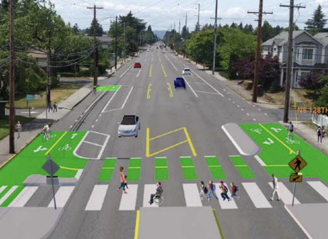
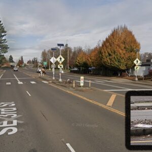
When looking at the above photo with the crossing I can’t help but notice that middle median. I think the crossing looks great, but it seems to me that having such a wide road encourages very high speeds. I’m sure there are reasons for the median (i.e., reducing lanes so what else are you gonna do with it, space for emergency vehicles, etc.), but how can a design create the feeling of a tighter space that would reduce speeds? Could there be a bike/ped space down the middle? Could there be a dedicated bus lane? How many deaths happen at night, when those on-street parking buffers are empty and motor vehicle drivers have the impression that it is safe to make a bad decision, tear down the street and cause a fatal crash?
The bottom graphic is an out of direction greenway crossing of Glisan at 128th – part of the 130’s greenway. I don’t know why the out of direction path, other than to avoid adding a new crossing close to an existing one.
Maybe because of the elementary school on the south side (Menlo Park) and a senior services center on the north side? Too many school buses and not enough TriMet? East Precinct police cars routinely hitting the nearby BES bioswales at 90 mph late at night on non-emergency runs? Excess speeds and capacity on Glisan that might encourage others to drive 30 mph over the speed limit? Gosh, I just don’t know why.
How’s the view from the east coast?
The school is right at 128th, but the proposed marked crossing is east of the exit driveway, where drivers turning right will be looking left.
The elder care facility is 2+blocks east of this graphic. A crossing closer to the school front door, or the elder care front door, would better serve those two facilities.
No reason to make cyclists go the wrong direction to cross Glisan, only to have to back track.
Maybe you don’t know.
No, I know that crossing quite well, I would use it a lot when I lived there in EP 2007-2015. And I agree the design doesn’t really take into account how riders currently cross at this point or will even after the improvements are put in.
To answer your first question, in general drivers are just as fast here, streets are much wider than in Portland, sidewalks when they exist are much narrower, bike facilities are few and far between, but in general drivers are much more friendly here than in Portland. Much to our surprise, we had LimeBike’s first ever citywide dockless bikeshare program in the nation. Scooters have just been made legal for all streets with a speed limit of 35 or less (95% of our street network), but are banned from all our sidewalks. (We have both Bird & Lime scooters.) Our area covers the same as Portland but with half as many people (lots of sprawl), the downtown is dead, the airport has no transit service to speak of (along with half of our city), and it’s impossible to take transit to most good-paying jobs, including those downtown.
On the plus side, it’s 60 degrees right now, my rent for 2bd+W/D+D/W+A/C=$700/m, we have a very nice national battlefield right in town, 2 public universities, neighborhoods are very quaint, and strangers say Hi and wave to you on the street (Southern Charm.) Our city council are 5 white women, 3 black women, and one black man (no white males at all), 5 elected by districts, 3+mayor elected at large. We have a very efficient City Manager and a completely inept transportation department. Our city budget is over $500 million/yr. I’m still unemployed but currently serve on the local transit board.
I can’t remember clearly when it was, but there was a BP article with a redesign for Division with tree-lined medians at 130th. At the intersection of 122nd, maybe they could do public art on the medians? Or maybe a wrecked car, to remind users to slow down?
I’m also thinking the curb extensions are being redesigned for inner Portland to create “protected crossings” at intersections, why isn’t it being reflected for outer Portland crossings where so many pedestrian deaths are happening?
What they need are narrow slip lanes for bicyclists and scooters, with the signal poles on the inner ped islands, and then median islands midway on the crossing, like they do in Paris.
I like the idea of a dedicated, “floating” bus lane that changes direction based upon the time of the day (e.g. west-only during morning peak commute hours and east-only during evening peak commute hours). The Bay Area had floating HOV lanes over a decade ago. It requires crews to flip the dividers twice a day with specialized machinery, but there are precedents elsewhere of this practice.
This is really cool to see!
Clearly they mean well and maybe planning to plan to fix something is better than nothing, but we know what the problem is. Can’t we get going on it already?
There has always been a reluctance to spend money on this part of the city. A lot of lip service and photo ops with little action to follow it up.
There is irony that people are worried about “cut through” traffic…and therefore want traffic (cars, let’s call it what it is) be kept to arterial roads. Yet, I bet if we looked at the driveways of these people, we would find cars in their driveways, on their streets or in their garages.
So, let’s just get this straight. The complainer has every right to drive their killer car to and from their arterial, around their neighborhood or anywhere else at all times of the day, because you live there, but if I want to take an alternate route and obey the law/speed limits, I am not allowed to use the street in front of the complainers house?
That’s an interesting premise considering that street is paid for taxes by all. Now, I am not for more car use, I just want to expose the hypocrisy of these nimbys. You see, they are really against calming the surface highways but couching it as a “cut through/traffic in my neighborhood” issue. And a lot of them, post on this site. Beware.
I support cut-through traffic in my neighborhood that goes at or below the speed limit. Is there a filter we can apply to divert the cut through drivers who are speeding?
roundabouts! if they can put one on 39th and glisan why not 82nd or 122nd? I would start with 82nd isn’t it supposed to be the ‘avenue of roses’ or some such now? put rose gardens in the middle of the roundabouts. Proven to reduce speeds and fatal accidents.
I completely agree with you, East Portland traffic safety and speeds would be transformed if all or most major signalized intersections were replaced with roundabouts, as the intersections are already prohibitively dangerous to cross by foot and bicyclists avoid them if they can.
According to urban legend (i.e. PBOT staffers who can’t actually prove what they said), PBOT did in fact build a roundabout 20+ years ago on 122nd somewhere between Stark and Powell, but not at Division. Apparently the yellow school buses of the David Douglas public school district kept hitting it so much that PBOT then completely removed it after only a few months at enormous cost. PBOT was so horrified by the experience that they decided to never again build one in East Portland.
The reality is that there’s no evidence on the ground it was ever built, nor can PBOT staff find the plans for it, nor any pictures, newspaper reports, etc. I personally have my doubts it was ever built, but rather it was designed and then DDSD lobbied to make sure it wasn’t built.
But maybe one of the numerous PBOT “insiders” who read this blog can give us some insight? Why does East Portland have no roundabouts?
nice, never heard that story about the 122nd roundabout. maybe they did a temporary treatment? of course to really do one i imagine you’d have to relocate power poles and fire hydrants and such, so a temp treatment probably wouldn’t be as good as the real thing.