
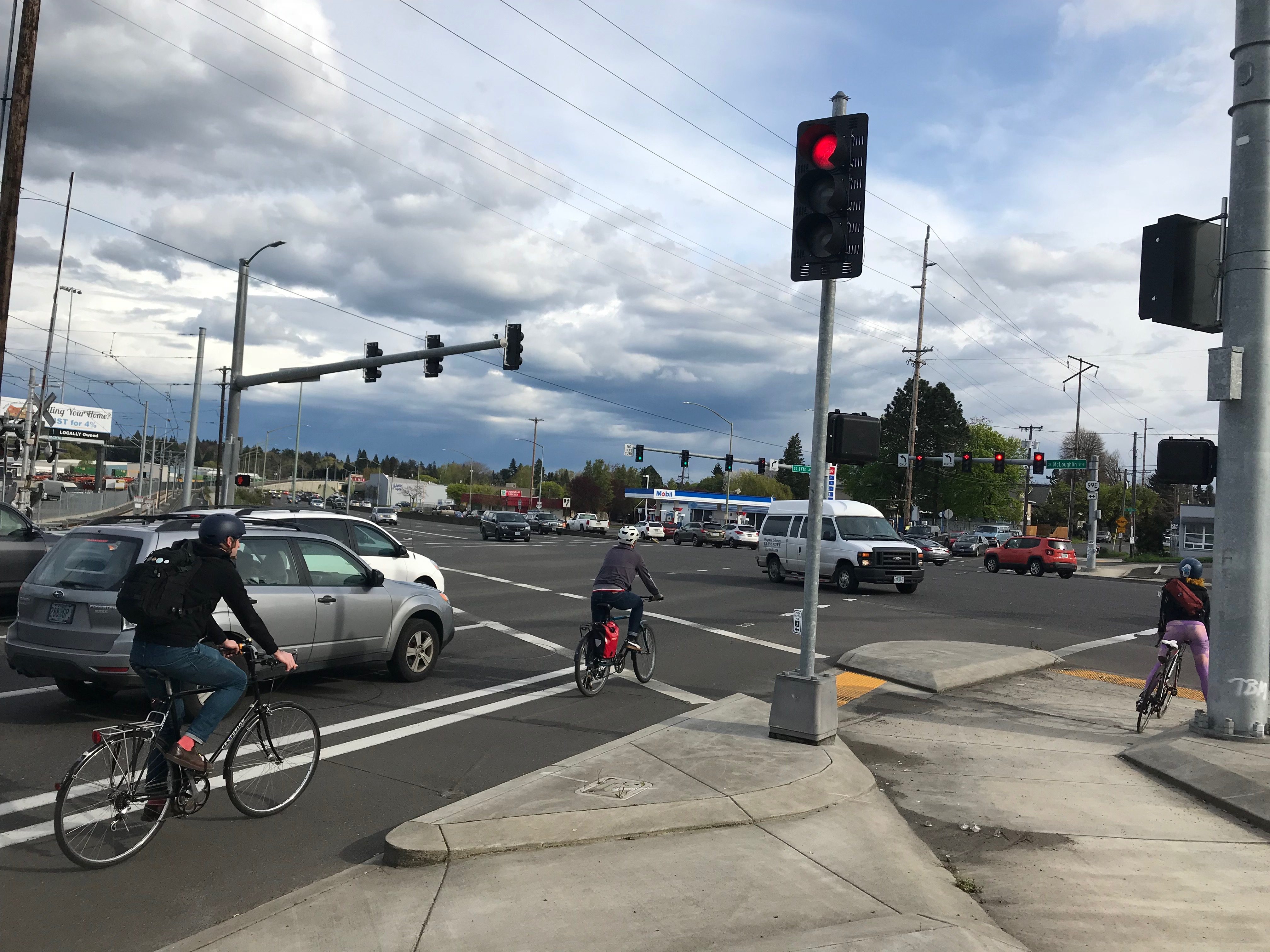
(Photo: J. Maus)
Portland’s bike planning is about to get smarter.
“The city has the right ideas but they don’t have the right tools.”
— William Henderson, Ride Report
The Portland Bureau of Transportation announced two major data-driven projects last week aimed at making biking safer. PBOT purchased data from Portland startup Ride Report, and plans to install smart safety sensors on three of the city’s most dangerous streets.
Together, these projects will flood planners with new data on bike travel patterns (and a whole lot more).
“Now you see more and more data becoming available from traffic sensors, smartphones, bike share,” says William Henderson, one of Ride Report’s co-founders (whom you might recall from our 2015 profile). “We want to help cities effectively use that data.”

This type of collaboration is part of the “smart city” approach to urban planning that’s gaining traction across the country. Cities are scrambling to partner with tech companies, and tech companies are grabbing for public dollars. The mobility services sector— think carsharing, mobile ticketing and any project coming out of company’s like Portland-headquartered moovel — is booming.
There’s been plenty of talk about smart city projects for transit and cars, but less for bikes. Portland will be the third city, behind San Diego and Atlanta, to pilot the traffic sensors. Ride Report has made it into 13 cities.
“The city has the right ideas but they don’t have the right tools,” says Henderson. “They don’t move like a tech company. On the other hand, you have tech companies that don’t understand how cities work. It’s important to have something in the middle.”
In the old days, when PBOT wanted to see how many people were biking at a specific location, planners collected surveys and sent out legions of employees and volunteers to manually count them. That process could take up to six months.
The smart sensors automate at least part of the process. Unlike humans, they can count several things at once — such as when and where people cross the street, and how fast they’re going. The sensors’ cameras can even pick out different shapes and sort them into cars, bikes and people, kind of like how Facebook recognizes your friends in photos.
PBOT plans to install 200 sensors on light poles in three high-crash corridors. The agency was restricted to light poles owned by Portland General Electric, one of the project partners. They settled on 122nd between Burnside and Duke, SE division between 11th and 22th, and Hawthorne between 11th and 46th.
Advertisement

The total price tag is just over $1 million. That includes the sensors, installation costs and the software to make sense of all the data.
The sensors will turn the tables on street design. Instead of painting a crosswalk and hoping people use it, planners can do the opposite. They can look at where people actually cross, according to the sensors, and fill in the missing crosswalks.
Capturing the quality of the bike trip
The sensors can tell how fast you’re driving, where you’re going and how you’re getting there. But they can’t tell another critical variable — how the trip makes you feel.
“What you’re not going to get from the sensors is reports on comfort level,” PBOT Communications Director John Brady shared with us in an interview this week. “Just sitting on the sidewalk doing a bike count you can’t get that qualitative data.”
That’s where Ride Report comes in. With the Ride Report app, people on bikes track themselves with their phones, and report the ride’s overall vibe: “stressful,” “chill,” or “mixed.” Users logged 1.2 million bike trips in the first year. That activity shows up on a user-generated map as a web of red, green and yellow lines.
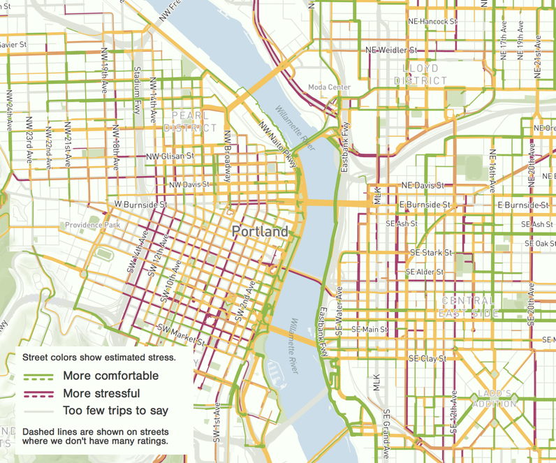
Then planners just have to find the fattest red lines and steer public dollars in that direction.
You’re probably wondering where the chill rides are, and which routes to avoid. The answers aren’t surprising to anyone who’s spent more than a few days in the saddle in Portland. The danger zones include North Interstate, the southern end of Mississippi Ave., Milwaukie, and Woodstock.
By entering into an official partnership with Ride Report, PBOT planners get added data visualization superpowers not available to the general public. They can see the difference between peak and off-peak hours, for example. Henderson says, “we’ve seen facilities that are really good during off peak hours, and degrade during rush hour.”
PBOT is paying $25,000 for the data, and spending another $5,000 on staff to figure it out. Henderson says the price tag is probably less than what the agency spends collecting data for a single project.
“They definitely shouldn’t spend money on us before they spend money on bike lanes,” Henderson says. “But you have to spend on data.”
Who gets counted – and how — matters
“This is just one new tool for us.. We are mindful of its limits and the opportunities.”
— Dylan Rivera, PBOT
We don’t know how this project will affect low-income and minority people who choose to bike and walk. At a recent event hosted by Forth, an electric vehicle advocacy nonprofit, OPAL’s deputy director Vivian Satterfield warned against tech-driven approaches to transportation issues. Many low-income people use smartphones, she said, but mostly for text and email. They’re probably not using Ride Report. Planners might need to find other ways to make sure they’re concerns are reflected in the data-driven designs.
And then there are the privacy concerns. At a time when people are re-assessing their relationship with Facebook over its rampant misuse of personal data, it’s likely the public will be skeptical of sensors of any kind.
And Sarah Iannarone, a PBOT Bicycle Advisory Committee member and local activist on many fronts whose daily critiques of Mayor Ted Wheeler seem to be a precursor to another run at his office, offered sharp rebukes to the smart city tact on Twitter yesterday. The “corporatist push toward ‘Smart City Portland’,” she warned, “never serve people over profits.” “Long-term prosperity hinges on climate adaptation and social cohesion, not tech,” Iannarone continued. “We need a ‘Resilient City’ era with a focus on stupid networks like sidewalks.”
PBOT isn’t blind to these concerns. “This is just one new tool for us, that will supplement our existing public involvement and data research,” spokesperson Dylan Rivera says. “We are mindful of its limits and the opportunities.”
Futuristic tools and future projects
Putting a number on subjective feelings like stress, Henderson says, will prove invaluable in the Central City 2035 plan. Staff working on Central City in Motion and projects in east Portland might also make decisions based on Ride Report, a spokesperson said. The agency could spend up to $254,000 over five years.
Right now, Henderson is enjoying sitting at the front of the peloton of bike-focused data startups. Henderson says he doesn’t have much competition. Moovel’s data, for one, is more general and transit-focused.
But Henderson is gearing up for a tight race. He hired two software engineers recently. He’s looking for two or three more. “Biking is really going to heat up,” he says. “We’ve been growing to meet that demand.”
With data pouring in from all sides, the challenge moving forward is figuring out what it means. Most of the money budgeted for the sensor project is going toward analytics. As smart cities grow, so will the need for data analysts and sophisticated statistics software.
“Everyone has so much data,” PBOT’s Brady says. “No one knows how to actually integrate the data to draw any conclusions. The next challenge is developing the analytics we can use.”
Smart City PDX Team Open House and Tech Expo
Where: Community Hall, Portland Community College – Southeast Campus, 2305 SE 82nd Avenue, Portland OR, 97216
When: Wednesday, April 25th, 2018 from 6:00 to 7:30 p.m.
Who: Representatives from the Office of Mayor Ted Wheeler, Smart City PDX Team, AT&T, Current by GE, Intel and Portland General Electric
Representatives from the Traffic Safety Sensor Project Team will be present to explain the project and answer questions. Representatives from Current by GE, AT&T, Portland General Electric and Intel will also be at the event with displays of the sensor technology.
Please RSVP with Anne Hill, Smart City Coordinator, at anne.hill@portlandoregon.gov
— Caleb Diehl, csdiehl16 [at] gmail.com
Never miss a story. Sign-up for the daily BP Headlines email.
BikePortland needs your support.