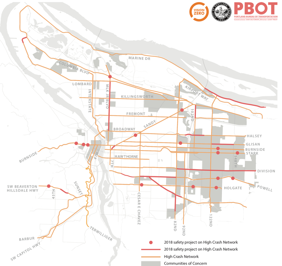
With money in their coffers for the first time in several decades (thanks in large part to the local gas tax and revenue from the state transportation package passed last year), the Portland Bureau of Transportation will be busy in 2018. They recently released a list of 17 projects they plan to construct this year. Nine of them are east of 82nd.
While this isn’t every single thing PBOT will build in 2018, these 17 projects have been singled out because they are on their ‘High Crash Network‘ — a list of streets with “the highest number of reported collisions overall and for people walking and biking in the five‐year period from January 2011 through December 2015.” The projects on this list are queued up for 2018 for a variety of reasons, including a new internal ranking system PBOT uses to flag the most urgent needs.
Keeping to their promise to put data and analysis at the core of their Vision Zero-focused decision-making and prioritization process, PBOT used three metrics to rank intersections on the High Crash Network: Number of fatal and injury crashes between 2011 and 2015; the collision rate (“the number of crashes at an intersection are normalized by considering the number of cars traveling through the intersection”); and the total value of crashes, which assigns a monetary value to the severity of injuries.
They even shared their work. Here’s the formula for collision rate:
Collision Rate = (Crashes/5 years) X (1 year/340 days) X (1/ADT) X 1,000,000
And here’s how they figure out the total value of crashes:
Total Value = # Deaths* Death $ + # Inj A* Inj A $ + # Inj B* Inj B $ + # In C* Inj C $*
(*Death value: $1,500,000; Injury A value: $74,900; Injury B value: $24,00; Injury C value: $13,600)
When those calculations are cross-referenced with other PBOT metrics like “communities of concern”, shovel-readiness and political support, here are the 17 projects that made the build list for 2018 (UPDATE/CORRECTION, 2/1: An Oregon Department of Transportation employee has informed us that projects #1 and #15 are ODOT projects, not PBOT projects. We’ve noted that below and apologize for any confusion.)
Advertisement
1. 82nd Avenue (*This is an ODOT project)
Signal repairs and ADA upgrades at Foster, Woodstock, and Flavel2. 102nd Avenue
Sidewalk infill (Sandy to Fremont)3. Beaverton-Hillsdale Highway
Protected/buffered multiuse path (30th to 39th), safer crossings at 30th and 35th, intersection safety at Shattuck4. Burnside Street, East
Safer crossing at 129th5. Burnside Street, West
Sidewalk on north side (Uptown Terrace-NW 24th Place), safer intersections at 18th/19th and 20th6. Columbia Boulevard
Intersection reconfiguration at Martin Luther King, Jr.7. Division Street
Raised center median for safer turns and crossings (82nd-92nd, 116th-146th), sidewalk in ll, and protected/buffered bike lanes8. Foster Road
Widened sidewalks, enhanced crossings, street trees, bike lanes9. Glisan Street
Safety fixes at 87th, 122nd, and 128th, buffered bike lanes (122nd-148th)10. Halsey Street
More lighting, enhanced crossings, protected bike lanes, and speed limit reduction. Two-way bike lanes on I-205 overpass11. Holgate Street
Crosswalks and ADA upgrades at 41st/42nd, signal reconstruction at 104th, safer crossing at 128th12. Lombard Street
Protected bike lanes (Terminal-Sever), multiuse path (Sever-Columbia), protected left turn signal at Time Oil Rd.13. Marine Drive
Bike lanes buffered with rumble strips (112th-122nd), multiuse path infill, rapid flashing beacons at 112th and 138th, new traffic signal at 122nd14. Martin Luther King, Jr. Boulevard
Safety fixes at multiple crossings (Broadway-Lombard)15. Powell Boulevard (*This is an ODOT project)
Lighting and crossing fixes (20th-34th), safer crossings and/or bus shelter enhancements at nine intersections (Chávez-82nd, 131st, 145th)16. Sandy Boulevard
Rapid flashing beacons (31st), bike lane safety fixes (Burnside-Stark), safer crossings at 85th and 91st, westbound bike lane (91st-I-205)17. Stark Street
Safer crossings at 130th and 155th
Learn more about PBOT’s High Crash Network and see the individual intersection rankings and project descriptions at PortlandOregon.gov/transportation.
— Jonathan Maus: (503) 706-8804, @jonathan_maus on Twitter and jonathan@bikeportland.org
Never miss a story. Sign-up for the daily BP Headlines email.
BikePortland needs your support.


I’m grateful for the BH Highway project at SW Shattuck Road because it will clean the stormwater and remove the right-turn lane.
The stretch of BH-Hwy from 30-39 was done last year (and rubber curbs shouldn’t take this long) as mostly a re-pave. Frustrating for them to take credit twice on that while they punt Vermont, ignore Multnomah (RIP Kurkowski), Taylors Ferry, Terwilliger, and the rest.
If it makes you feel any better at least most of the paint on the outside stripe is faded away (goodbye buffer) because the speed limit hasn’t been reduced and people have not adjusted to the narrower lanes. This has been a terribly managed project, especially for cyclists, and it’s unfortunate that there have been so many delays with such limited protection.
Thanks for posting this. Good to see what is being done!
Regarding Marine Drive:
I sincerely hope that the “Bike lanes buffered with rumble strips (112th-122nd)” does not end up with those rumble strips taking away from the existing space available for bikes. If PBOT wants to add rumble strips to Marine Drive (and they seem hell bent to do so), then they should add the rumble strips just to the immediate LEFT of the fog line. Any reduction in space for bikes would be a tremendous failure.
PBOT added rumble strips to Marine Drive in both directions leading away from the 122nd intersection in June of 2014. This was after promising in 2012 that they would NOT add rumble strips to Marine Drive..http://bikeportland.org/2012/06/28/you-spoke-pbot-listened-no-rumble-strips-on-marine-drive-74022 The rumble strips that they added in 2014, were on the right side of the fog line and significantly reduced the usable space for bikes. After many complaints and emails, PBOT had those rumble strips removed several months later.
My confidence in how PBOT will treat the biking facilities on Marine drive is very low. My confidence that they will mistreat the biking facilities on Marine drive is high.
If #6 is the project that I was on the board for several years ago, then I’ll be disappointed.
I was the “Neighborhood Liaison” on a board with a bunch of traffic wonks for the planning phase. They wanted to widen the intersection so that XXL trucks could take the corner easier, and I wanted to make it easier for pedestrians to be able to cross/ people on bikes to be able to navigate. I got nowhere and they got whatever they wanted, as we didn’t form our decisions by consensus. There was a open house/ comment period that I tried to bring a group of neighbors too, but they closed early due to bad weather, and we never got to voice our neighborhood’s concerns.
Anyways I would MUCH rather have money go towards bike/ ped projects rather than widening MLK and Columbia.
Do you have any more details?
Foster’s Road between 50th and 82nd already has the widest sidewalks in the city.
If you look deeper, you’ll see the Foster project extends nearly to 92nd ave.
That’s not true. The sidewalk on Foster Road between 70th and 71st Avenues has to be only 5 feet across at best.
https://www.google.com/maps/@45.4870912,-122.5907696,3a,75y,350.79h,81.67t/data=!3m7!1e1!3m5!1sTqnSWsZtL9dgZxkqIbjvyQ!2e0!6s%2F%2Fgeo3.ggpht.com%2Fcbk%3Fpanoid%3DTqnSWsZtL9dgZxkqIbjvyQ%26output%3Dthumbnail%26cb_client%3Dmaps_sv.tactile.gps%26thumb%3D2%26w%3D203%26h%3D100%26yaw%3D307.97693%26pitch%3D0%26thumbfov%3D100!7i13312!8i6656
just 2 squares wide in most places… you may be mistaking the paved over planting strip as part of the sidewalk…
and in the few places it’s actually wide then you have sidewalk furniture narrowing it down to 2 squares again…
but a lot fewer motorcycles parked on the sidewalks now that certain businesses are gone…
This is great work and I hope it will save lives! Speaking of, I was wondering where PBOT takes the $1.5M for live lost from. This is an iffy topic but estimates for life lost are typically higher, around $9-10M. This is probably not important for these projects but different numbers could make a differences regarding what PBOT prioritizes.
According to the PBOT web site, they used a 2013 National Safety Council report. I couldn’t find it, but I did find a similar 2017 report (pdf) from the same group: http://www.nsc.org/NSCDocuments_Corporate/estimating-costs.pdf
According to this report,
COSTS OF MOTOR-VEHICLE INJURIES
The calculable costs of motor-vehicle crashes are wage and productivity losses, medical expenses, administrative expenses, motor vehicle damage, and employers’ uninsured costs. (See the definitions on the reverse for a description of what is included in each component.) The costs of all these items for each death (not each fatal crash), injury (not each injury crash), and per-damaged-vehicle were:
Average Economic Cost by Injury Severity, or Crash, 2015
Death (K) $1,542,000
Disabling (A) $90,000
Evident (B) $26,000
Possible ( C) $21,400
No injury observed (O) $11,400
Property damage only (cost per vehicle) $4,200
Estimates are given here of the costs by severity of injuries, as defined in sections 2.3.4 through 2.3.6 of the Manual on Classification of Motor Vehicle Traffic Accidents (7th Edition) ANSI Standard D16.1-2007.
However, they go on to talk about overall costs:
Comprehensive costs of motor-vehicle crashes.
In addition to the economic cost components listed above, the following comprehensive costs also include a measure of the value of lost quality of life which was obtained through empirical studies of what people actually pay to reduce their safety and health risks. The average comprehensive costs on a per injured person basis were:
Average Comprehensive Cost by Injury Severity, 2015
Death $10,082,000
Disabling $1,103,000
Evident $304,000
Possible injury $141,000
No injury observed $46,600
Since the lost quality of life figures, which are included in the above comprehensive costs calculations, do not represent real income not received nor expenses incurred, they should not be used to determine the pure economic impact of past crashes.
Thanks for digging that out! So what they are saying is that they do not measure costs to society when calculating these costs. If the objective is to compare costs and benefits to society, as is typically done in cost-benefit calculations, then the higher numbers should be used. Which costs are the correct ones depends on the ultimate objective of these calculations, but I would find it to be useful to calculate costs to society.
Is it just me and my computer, or are there a lot of “ff” typos on this list, such as “in ll” for infill, “tra c” for traffic, etc?
“13. Marine Drive
Bike lanes bu ered with rumble strips (112th-122nd), multiuse path in ll, rapid ashing beacons at 112th and 138th, new tra c signal at 122nd”
looks like a problem with only this item… can’t find this item on the City of Portland web site linked above…
Do they use the same death formula used to calculate non-motor-vehicle occupant deaths, aka if you die due to injuries over 30 days after the event, it doesn’t count?
Are statistics collected and kept for such incidents?
–On the Marine Drive improvements, what’s proposed is good, but whatever happened to the promised flashing beacons at the two hazrdous places where the multi-use trail crosses Marine Drive between NE 33rd and I-205? This was originally promised on PBOT’s web page for this project. And what about a desperately-needed new traffic signal at NE 33rd & Marine?
–On the MLK Blvd. improvements: I am most concerned about flashing beacons being installed on the neighborhood greenway crossings at NE Going and NE Bryant. These are terrible, dangerous crossings, and the RRFB’s have been promised for at least 3 years, but now PBOT is being awfully cagey about which intersections will get flashing beacons.
Anyone know more details on either of these projects?
Do the bike lane safety fixes on Sandy between Burnside and Stark include the clusterf*ck at Ankeny & 11th? Please let this be on their radar – it is the worst/scariest part of my commute. It’s a ticking bomb for a serious car/bike incident.
Do you have a suggestion on how to fix it?
I’m no traffic safety engineer, but IMO striping and signage will not cut it. The bike boxes help mid-intersection, but there is still tremendous confusion on who gets to go when, not to mention a lot of agressive drivers who get frustrated with the backed-up traffic at peak rush hour. Flashing beacons at a minimum, or signalization seem like the best way to mitigate the confusion for everyone and establish the priority for bikes and peds.
Agreed, that intersection is the worst one on my commute too.
ohhh MLK is a great route but no bike lane and cars seems to feel the rule over anything outside the box.. I was riding it early Sunday morning as direct route but wow almost t-bone by guy pulling out on me.. 🙁
All of these are terrific but… many these projects are specific to an intersection or crossing or 2 even though the crashes are all along the corridor. A real fix means lower speeds, fewer MV lanes, more separation, and shorter, better crossings. For example, the Foster project, not the (now delayed) Division project.
This is what I am talking about. The project list “fixes” SE Stark… at 130th and 155th. Today another person was killed walking at Stark and 148th, which is a “high crash intersection” on a high crash corridor. PBOT has no plans to fix 148th or the too-wide, too-fast conditions that plague the whole corridor and the people who live and work and die there.
http://www.oregonlive.com/portland/index.ssf/2018/02/woman_struck_and_killed_early.html
Why oh why are they doing sidewalk infill on 102 when there’s a great MUP running parallel just blocks away? It’s the stretch of 102 between Fremont and Burnside that really needs help, since it’s the only way to cross the highway and access services and businesses in Gateway without a vehicle. 🙁
If I remember correctly, the sidewalks for pedestrians and mobility-device users and not bicyclists per say, and are needed for local bus users on 102nd and for children walking to schools in the area (all in the Parkrose School District). Technically the MUP in question (I-205) is within the City of Maywood Park and maintained by ODOT and Multnomah County. Most of the sidewalks from Fargo to Burnside, and even as far south as Stark, are long completed, if not always very nice and pedestrian-friendly and rarely up to city standards. IMO, the scariest section is from Fremont to Fargo, as the road crosses I-84, especially on the west side of the street where the on-ramp is.
UPDATE/CORRECTION, 2/1: An Oregon Department of Transportation employee has informed us that projects #1 and #15 are ODOT projects, not PBOT projects. We’ve noted that in the post and apologize for the error.