
This is the latest from our columnist and TriMet Senior Planner Jeffrey Owen. Last month he gave us the inside scoop on the Orenco Station Bike & Ride.
Secure bike parking plays a crucial role in having options on one or both ends of a longer transit trip and helps to extend the reach of the transit service.
Thanks to a recent grant from the State of Oregon, TriMet is able to upgrade bike parking at two key MAX stations — Goose Hollow/SW Jefferson Street and Beaverton Creek. Here’s what in store for both of these crucial links in our bike-transit network.
For east-west commuters who combine bike and transit trips, the Goose Hollow/SW Jefferson St MAX Station is a major link for riders who bike through downtown Portland and then board a MAX train to head farther west. This route eliminates biking over the west hills and saves time between Goose Hollow and other westbound destinations. It is common for MAX trains to carry a high number of riders with bikes on both Blue and Red MAX lines. This is especially true on MAX Blue Line, which connects farther west than the Red Line, towards Hillsboro and many large Washington County employers, including Nike and Intel.
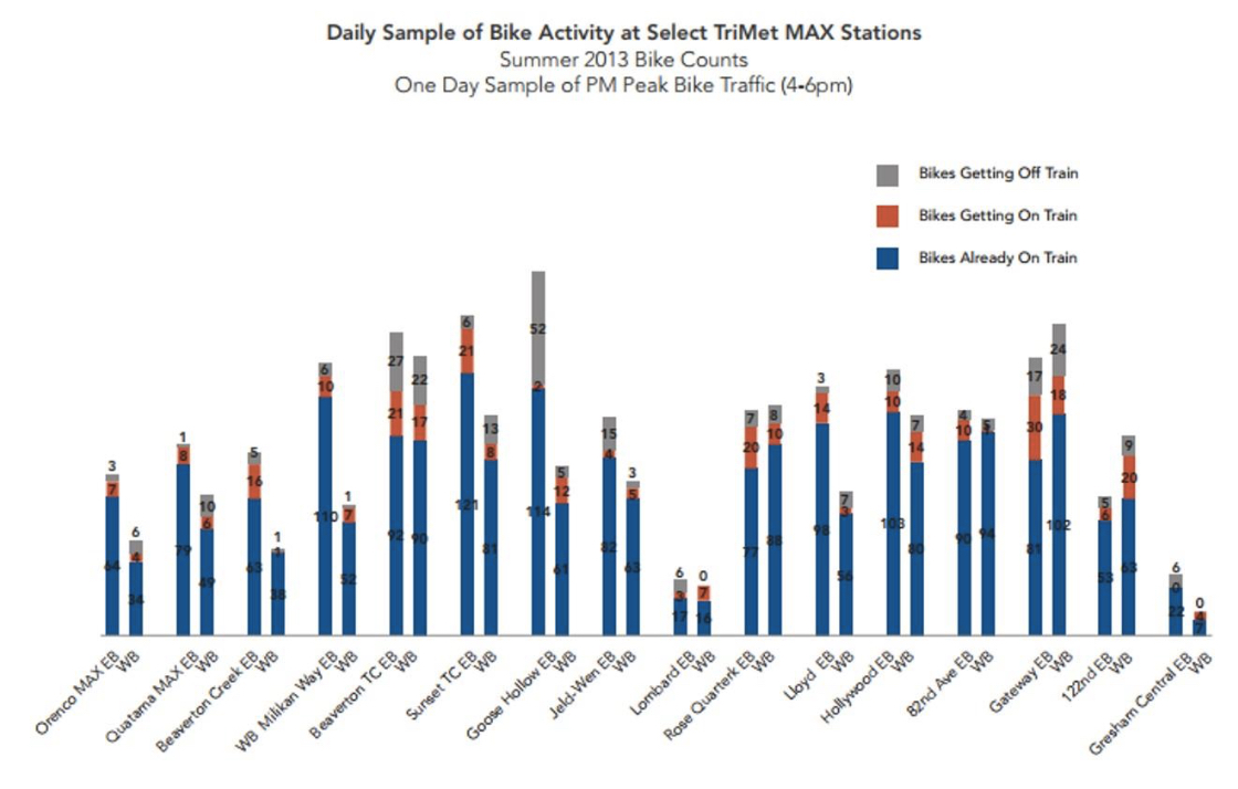
It’s no surprise that TriMet bike count data shows the Goose Hollow/SW Jefferson St MAX Station is among the busiest stations in the TriMet system for riders boarding with bikes. The graph below shows a limited snapshot of daily bike activity at select MAX stations around the region, with a large portion of bikes getting off the train in the eastbound direction at Goose Hollow/SW Jefferson St MAX Station (labeled as “EB” on chart shown in gray) in the afternoon:
There are numerous options for reaching transit service from home or work, what we often refer to as the “first and last mile” for transit access. When biking to transit, utilizing the full array of these options reduces the reliance on having to bring your personal bike with you throughout your entire trip. Bike & Rides offer a place for riders to store a personal bike on one end of their transit trip, and then use their choice of several options on the other end of the trip such as a TriMet bus, Community Connectors like the North Hillsboro Link, employer bus shuttles, employer provided bike share, or walking. Some people even leave a second, personal bike at another station.
Due to physical constraints of trains, and riders who need access to the priority seating areas, TriMet cannot accommodate every rider’s personal bike on the entire transit trip. Secure bike parking plays a crucial role in having options on one or both ends of a longer transit trip and helps to extend the reach of the transit service.
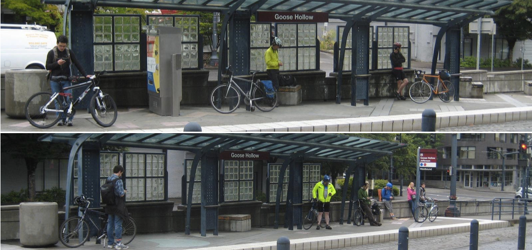
As seen in the photos below at the Goose Hollow/SW Jefferson St MAX Station, a typical weekday morning might easily find between five and ten riders with bikes waiting on the westbound MAX platform. It is also common for some riders to avoid this crowd boarding the train a few stops earlier to improve their chances for hanging their bike on the bike hooks.
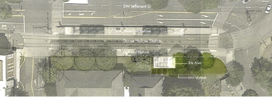
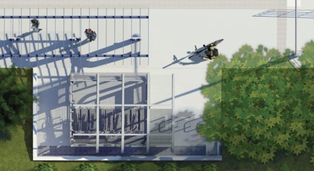
The Goose Hollow/SW Jefferson St MAX Station provides a particularly unique challenge to locate secure bike parking due to space constraints on all sides and a lack of available spaces upon which to build. The station area does not have a lot of extra space; secure bike parking was not originally part of the vision for this station.
We first began by considering various conceptual locations between SW 22nd and SW 17th Avenues, and from Providence Park to Goose Hollow. Quickly, it became obvious that the ideal site would need to be as close to the MAX platform area as possible. I reached out to the First United Methodist Church (whose property begins at the back edge of the eastbound MAX platform along SW Jefferson Street) to see if we could find a mutually beneficial solution to locate a new bike parking area for MAX riders. The church has been an incredible community partner who understood our constraints and was interested in helping to add bike parking to the Goose Hollow neighborhood. The Goose Hollow Neighborhood Association embraced the vision of the project and was supportive of our intentions to seek grant funding for its completion.
After working with the church for a few years, we reached an agreement for TriMet to purchase a small amount of property on the back edge of the eastbound platform from the church, and then dedicate it to the City of Portland right-of-way for the purposes of constructing secure bike parking.
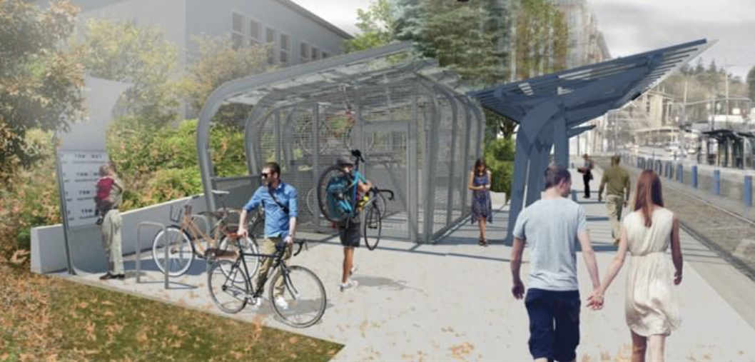
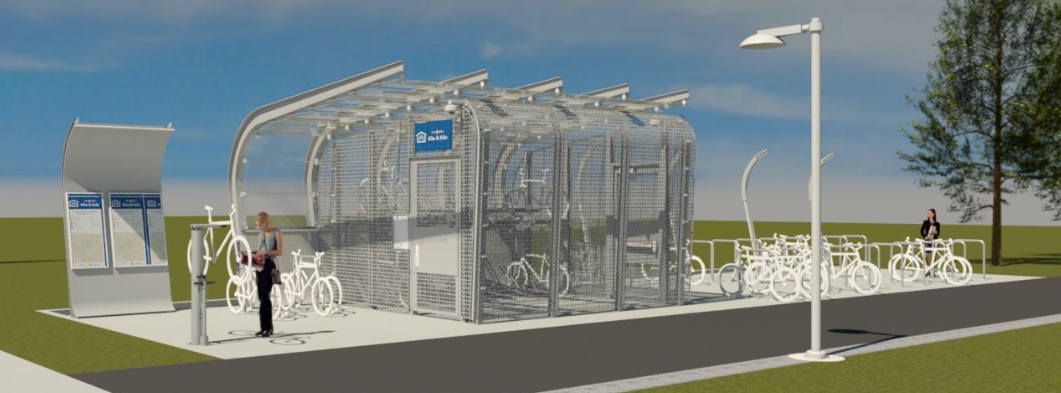
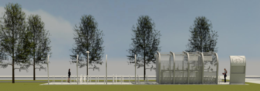
We’ve been progressing through the design of the secure bike parking facility, which will include about 30 bike parking spaces: 16 spaces inside an enclosed, secure area, and 14 spaces just outside, within coverage of security cameras. This has been an exciting and challenging project to work on over many years. It has pushed the envelope for creative solutions in tight spaces for TriMet delivering secure bike parking as an attractive alternative to taking your bike onboard already crowded MAX trains.
As part of the same project funded through the Connect Oregon grant, TriMet is also improving bike access to and across the Beaverton Creek MAX Station, with a recently completed, new path crossing. This path crossing increases access to transit for users getting to the MAX platform. With a new crossing in place, north-south and east-west routes across the MAX tracks are also improved. The Beaverton Creek Regional Trail, currently in design by Tualatin Hills Park and Recreation District (THPRD), will provide a new regional trail connection to this station and run east west in this area, between SW Murray Boulevard and SW 153rd Drive, and will utilize the recently completed crossing to connect over the MAX tracks. The trail will be designed, built and maintained by THPRD, and will increase connections for commuters and recreational riders. In addition, this location also provides a Park & Ride for transit riders arriving by car, secure keyed bike lockers and bike racks.

Reflecting increased demand at this station, a new Bike & Ride is on the way, designed at the same time as the Goose Hollow Bike & Ride. It will be similar in style, but with more open bike racks and a new direct connection to the trail. As a reminder, for safety, riding bikes on MAX platforms is not allowed.
We are excited to progress through final design, and happy to hear your thoughts about these two new Bike & Rides. Both facilities are slated to open in spring 2018.
Have ideas on improving access to transit by bike? Send them to bikes@trimet.org, contact TriMet Customer Service or add your thoughts to the comments below.
— Jeff Owen, TriMet.org and @jeffreysowen on Twitter
Never miss a story. Sign-up for the daily BP Headlines email.
BikePortland needs your support.


Let’s build an A-grade bike / walk path somewhere in the Washington Park / Jefferson Street on-ramp / Highway 26 corridor to Sylvan. The key connection.
Parallel to Kingston?
Thinking big, a tunnel through the west hills like the MAX has would be great.
The tunnel thing is what was originally proposed for the zoo tunnel. A good portion of the budget was allocated for it when construction was started. The money was spent and disappeared but no bike tunnel.
It might have been, but I don’t recall a tunnel for biking, paralleling the light rail tracks through the tunnel, ever having been seriously considered, let alone budgeted for. There was serious consideration to save money by not having a station at the zoo. Imagine the mistake that would have been, not to have built a zoo station.
I tend to think there are a lot of people that wouldn’t want to have to climb even the elevation that the zoo station rises to. Personally, I wouldn’t want to make a long climb through a tunnel. I don’t even like riding the train through the tunnel. If I had a commute every workday between Portland and the Westside, that I didn’t want to entirely subject my muscles to, I’d just start saving some money and get an e-bike.
A bike tunnel that long would have serious security/safety concerns. It would pretty quickly turn into a makeshift homeless shelter.
Yes. Somewhere between Kingston and Highway 26 with a removal of the rusting mini-rail road tracks by the zoo.
I wish TriMet would take a greater interest in these: http://ec-i21.geccdn.net/site/images/large/ABO_301-Tan-PadlockHandle.jpg
and in cleaning the bike lanes by the Sunset Transit Center. They are responsible for getting a contractor to clean them, and those bike lanes are largely neglected and in terrible shape. They ignored multiple requests from me this year.
Hi Dan, We do have a number of bike lockers available around the region, both electronic, on-demand (https://trimet.org/bikes/electroniclockers.htm) or keyed/reserved (https://trimet.org/bikes/lockersavailable.htm). Are you interested in more lockers in general, or a specific style, or location? Thanks for your mention of Sunset TC bike lanes – I’ll look into that to see if I can help improve their maintenance and cleaning.
I’m a big fan of solo lockers like you have pictured, and would use them if they were installed at the Sunset TC. I don’t have any interest in parking my bike in a shared cage where anyone else sharing the cage can take stuff off my bike, or take the whole bike for that matter. I’m using a shared locker at work, but only because it’s the only option and at least I have a smaller locker to store my lights in. I definitely preferred the solo lockers when they were available.
I typically send in multiple requests regarding that Sunset TC bike lane every year. I’d say it probably needs to be swept on a regular schedule every other month, as it quickly gets filled up with gravel, glass & sticks, in addition to the blackberry vines creeping out and the paint being worn away.
Thanks for hearing my grievances! 🙂
Absolutely Dan, thanks for sharing. We do have bike lockers at Sunset TC currently, 12 spaces total (6 spaces in silver lockers at the west end, and 6 in blue lockers at the east end). Generally speaking, bike lockers are not a very efficient use of space for us, so the group facilities tend to be more space efficient. But I definitely hear you.
“bike lockers are not a very efficient use of space for us, so the group facilities tend to be more space efficient”
Compared to a group locker, sure, but you can typically fit 10 solo lockers in a single car spot. Of course, if people aren’t using them then they aren’t very efficient. Maybe I’m the only one interested…
“Generally speaking, bike lockers are not a very efficient use of space for us”
This comment struck me as out of place. Saying that 12 bike lockers are a poor use of space at Sunset TC (or anywhere else) made me chuckle and groan simultaneously (metaphorically, I’m not sure how that would be expressed). Given that there are 630 auto parking spaces at this same facility it’s clear where TriMet’s priorities lie. Further this model of charging people for a shared space to park their bike more securely but providing is disincentiving the most efficient use of space for people using a vehicle to get to/from TriMet facilities. It would be great to see the “open” parking be covered as it allegedly rains in this part of the country for 8-9 months/year and no one likes to sit on a wet seat after getting off the bus/Max.
This is a more general critique as I like the overall concept and design of the bike and ride facilities. The absolute worst use of space at a Park and Ride should be considered the SOV that ends up in the lot. Adding more carpool spaces would be better but ultimately converting auto spots to bike parking is going to provide the greatest density.
TriMet should be focused on helping get people out of their cars in any way possible. Encouraging people to use the generally worst form of transportation from a space and efficiency standpoint also has a deleterious impact on TriMet as buses get stuck in the traffic caused by this misallocation of resources. I’m not saying people shouldn’t drive, however there are ways to adjust people’s decision-making in the aggregate. These bike facilities really do need to anticipate more bike usage, especially outside of downtown where space is abundant.
There are 417 parking spots at the Beaverton Creek Park & Ride and it apperently isn’t even full based on this note: “There are usually spaces available in this lot at all times.” Could some of those spots be reallocated if/when demand grows due to the improved connection and facilities? In Goose Hollow there are obvious space constraints but elsewhere TriMet should be planning these projects based on increased usage due to better facilities, not using current data and thinking that utilization will remain static. We have seen with countless infrastructure improvements that if a route is no longer terrible people will use it.
This is a great series, thank you for providing a glimpse into the work you are doing to improve bike facilities in the TriMet service area!
Thank you David – I was meaning specific to bike parking spaces, not thinking about car parking spaces in that particular thought. It’s possible we can perhaps change the current structure of charging for secure bike parking in the future, to avoid the disincentive you mention. There are some pros and cons and some nuance to that. I definitely appreciate your thoughts and taking the time to share them!
Tri-met has a delicate balancing act to perform here. They have to at least appear to be supportive of people getting out of their cars, which means not being overtly hostile to cycling. However, at any point in time there is a limited percentage of the population who is willing to get out of their car, and transit competes with cycling for those butts.
So, just supportive enough (provide a wee bit of not really secure uncovered parking) but not too supportive (provide bike lockers and remove parking for SOVs) is what they will sell us. We’re supposed to be overjoyed because it’s bikey.
Washington County didn’t bother to make wider bike lanes when they repaved SW Barnes Road by St. Vincent hospital in 2016. Plus, PGE crews blocked a sidewalk and a bike lane on the opening day of school this week by Catlin Gabel.
A ped/bike path between Washington Park and downtown Portland would make sense, especially in situations where the trains aren’t running. Should’ve built it while the west side tunnel was being built. This could connect further West out to Banks and North to Forest Park. This would be a popular connection if it becomes reality.
The Washington County / Multnomah County commissioners need to work on this. I think Greg Malinowski would support it.
The Goose Hollow bike park and ride is a great idea as many eastside bike commuters know the MAX is extremely slow through downtown. It would be nice to see the City prioritize a high speed bike route through downtown to this station to encourage Washington County bike/train commuting. I used to work on the other side of the hill and would often take the train two stops from Goose Hollow to Orenco Station (where it averages 40+ mph) then ride across the bike/ped bridge over Hwy 26. From there it is a straight shot down SW Park Way (a relatively quiet neighborhood street) to Nike. Getting off at Orenco allows you to avoid the relatively slow section through Beaverton. I think it would be smart for Nike to run shuttles up to the top of SW Park Way in addition to Beaverton Creek as it would cut 10+ minutes off employee commute times. Maybe they could even install a Biketown station at that location so employees could ride down the hill to work (with e assist bikes for the evening uphill ride).
*I meant to say Sunset TC, not Orenco.
At the Beaverton Creek Station is the Nike Wood Connector Trail open to the public or is it for Nike employees only like the Hollister Trail? Anyone know?
“…the Nike Wood Connector…” bikeninja
Sounds like you’re referring to the paved north-south path through the woods from the station over to Jenkins.at a point very near the main Nike campus entrance. Dawn to dusk, that path is open to the public, based on a call I made directly to Nike Security about a year ago.
It’s a very nice though short path to ride too. I hope people riding it, concentrate on riding it at little more than a walking pace, out of consideration for the natural beauty of the surroundings, and for the opportunity for peace and serenity of other people out for the brief respite from work pressure this wooded trail has to offer. Thank you Nike for considerately opening this trail to the public!
I didn’t ask about it, but I presume the Hollister trail, which I’m somewhat certain is the trail around and just inside the perimeter of Nike Woods, is not open to the public.
Awesome! How about a nice protected lane on the five-lane highway that is SW Jefferson?
If you like Jefferson, you’ll love Barnes: https://goo.gl/maps/FHnRS4PdpzC2
There will be a new trail connection on SW Mayway Drive at SW Miller Road to connect to SW Leahy Road because of a luxury retirement center being built behind the QFC grocery store right now. It will allow people to avoid the part of SW Barnes Road where a legit bike lane / shoulder does not currently exist. It will involve some possible steep hills, though.
Any idea how many bike+train users can get by without the bike on one end of their journey? I don’t commute to Beaverton but whenever I go I use a bike to complete the last 2-10 miles of my trip.
I use the train for a mixed-mode commute from North Portland out to the Aloha area in the winter months. I have the same experience: parking at one end of MAX or the other isn’t an option unless I want to walk a mile or ten, depending on which west-side stop I select for leaving the train.
What ever happened to the idea of a cycle path up Jefferson and along 26? That would cut out a couple hundred feet of climbing compared to the alternates. If it shortened my travel time enough over the alternates, I could probably manage it without the train even in the cold of winter.
Hi Stephen, just curious – have you tried any other options on the Aloha side? Such as bus line 52, or 88?
Hi Jeff,
No I haven’t. For my commute, the 52 and 88 bus lines don’t make sense. They just add MAX stops at Beaverton TC to wait for a bus. The closest those two lines put me to my destination is Willow Creek/SW 185th TC, about a 3 miles away. With the bike, I generally get off at Sunset TC, Beaverton TC or Orenco Station and ride from there to my office. Which MAX stop I choose depends on the how wet and cold it happens to be outside. If I’m on foot (infrequently), I take the 44 from St. Johns to downtown and then ride MAX out to Orenco and either walk the last mile or grab the Link Shuttle. Using just feet and transit, it’s about a two-hour trip one-way. Taking the bike downtown and catching MAX pares it down to 90 minutes, one way. Using a car cuts the time to 45 minutes, one-way. Ideally, I’d like to see is a commuter rail along Hwy 30 and Cornelius Pass Road into Hillsboro. There is actually a little used rail line (Portland & Western Railroad, I think) for much of the way that could facilitate a WES style train. I imagine something like that could make taking the train from St. Johns to Hillsboro competitive with driving times.
Stph
Have you rode a bike from the Beaverton transit center to SW Center Street and then across 217 via SW Cabot Street and using the dirt / gravel path on SW Sunnyhill Lane to cross SW Walker Road at SW 106th Ave? The side streets on the north side of SW Walker Road lead to the Highway 26 multi-use path from 107th.
I haven’t tried that route. I usually take Park Way from Walker when I’m heading over the hill via the 26 MUP. How easy is it to get across Walker to 107th from the 106th stop sign?
Not sure why, but I never cared for going up the last bit of Park, from Parkwood to Butner. I’d rather turn right at Parkwood and go up Winthrop/Roxbury to Wilshire.
Easy. Clear line of sight both directions. I do it all the time.
“…What ever happened to the idea of a cycle path up Jefferson and along 26? …” keller
Was there ever a design drawn up for such a cycle path? If so, what form did it take, different from the emergency lane shoulder already there?
It’s a surprise to me that anyone thinking about riding a bike alongside Hwy 26 up the hill to Sylvan would feel it’s worthwhile to be inhaling all the full throttle exhaust from motor vehicles, to save a couple hundred feet of climbing through beautiful, quiet park roads and neighborhood streets.
Purely personal reasons that can summed up in two words: old knees.
I’m sorry about your knees. At least you’re determined to continue riding! Seriously, if it’s the extreme hills you’re distressed about having to climb…consider an e-bike.
They cost a fair bit of money, good ones do. I don’t have one, have barely ridden one, but seeing others riding, e-bikes look like a super great idea for many people. The potential is great, not just for climbing hills, but for hauling stuff too.
I don’t know, but things are moving very slowly on the eastside of Washington County. More bus service started this week for bus 52 on Farmington Road / 185th. A sidewalk has replaced an unofficial bike lane on SW 90th behind St. Vincent right where a small grocery store is being built with new housing. Beaverton Public Works just built a new 10 foot concrete path at the eastern end of SW Milikan Way that connects the Beaverton Transit Center to the local Bike Gallery.
Kudos to Jeff for making these projects a reality. They are much needed infrastructure that will make biking and transit better for the whole region.
The lack of secure bike parking at Goose Hollow was *THE* missing link for me when I lived in Portland and commuted over the West Hills daily. I could easily have done without a bike on the westside and would have been glad to ride MAX without one, but no good place to park it.
As it was, I usually dragged my bike on the MAX in the morning (not typically too crowded at my usual commute time), then biked all the way home in the evening (when getting a bike on MAX was usually hopeless).
This would have been a game-changer for me, and I hope that it is for many others.
Tri-met’s gesture of encouraging greater use of bikes for at least some part of people’s daily commute and other trips, is commendable.The potential though for this kind of planning and design to be able to significantly address issues of road use congestion, or even demands upon the tri-met system, seem infinitesimally small.
The ‘bike and ride’ concept sounds like a nice amenity for people that bike and would prefer not to be stuck on light rail, the bus, or lug themselves over the big hills like the West Hills for their entire commute. Other than that, this type of project seems very expensive for the return in increased use of bikes in conjunction with mass transit. And for the potential it has to help reduce motor vehicle use. Still…might as well keep at it. The thought, and receptivity to new ideas does count as something good.
30 bike parking spaces in Goose Hollow? That will fill up by 7am.
This will fill up quickly, for sure. Are there any options for expansion?
Space and funding would be the biggest challenges to expanding the Goose Hollow Bike & Ride in the future. I hope it does fill up, and that forces us to keep at it, working on an even better solution.
At Beaverton Creek Nikeites routinely ride their orange steeds across the MAX platform.
Moderately annoying.
On the other hand, Beaverton Creek is the only MAX station located by a well used cricket pitch.
Hi Jim, with the new small path connection on the way, we hope this behavior will be eliminated. Riding on the newer path should be a more comfortable and direct connection for people on bikes using the trail crossing, leaving the MAX rail platform for those specifically getting on and off the MAX train (as our rules imply, and hopefully common courtesy by most).
Goose Hollow needs a moratorium on the new construction of car dealers if there isn’t one there already. That car dealer on Jefferson would be a great spot for a grocery store.
THPRD is planning and designing the connector trail ? The THPRD trail that I use, when it is not blocked by Portland Water Bureau’s ongoing sewer project that has shut down the trail three times in the last year, is narrow, with sharp drop offs, and has a parking lot transistion that has taken me down on a rainy day. May I suggest that planning transit projects, which us what this is, is not their area of expertise ? And while I think that transit projects that keep people out of their cars should be better funded, it bothers me a bit to see taxes that I pay to a parks district being diverted to a commuter project without a greater level of transparency.
“…The THPRD trail that I use, when it is not blocked by Portland Water Bureau’s ongoing sewer project that has shut down the trail three times in the last year, is narrow, with sharp drop offs, and has a parking lot transistion that has taken me down on a rainy day. …” vince
Where is this section of trail, which you say has been obstructed at times by the Portland Water Bureau? Sounds like part of the Fanno Creek Trail east of 92nd Ave. Is that part of the trail actually a THPRD job? I’m not sure.
So far, the philosophical approach to trails for road biking in our area, Beaverton, Portland, and other cities, tends to be almost exclusively weighted in favor of recreational use, slow riding, rather than utilitarian trail for fast, efficient, safe travel by bike. Almost all the trail I know of in the Beaverton area are kind of narrow, twisty and asphalt paved. They’re often bumpy, not smooth like asphalt paved roads. Though it has some abrupt seams, Tigard has a decent concrete paved path out near Cook Park.
Yes, east of 92nd. Yes, it is a THPRD trail. The project, while a Portland sewer project, is actually located in Washington County. That has been an issue for residents along the trail. When the line leaks or ruptures, as it has done a number of times, complaints go on deaf ears as it us Washington County people complaining to Portland officials. Not surprised by your confusion on jurisdiction. In the Garden Home area, people who live here are often unclear which city or county holds sway on a given location.
As to the bumpy, slow trails, most those in the Beaverton area are THPRD owned and maintained. As you say, they tend towards recreational with turns and poor surfaces. An exception? The one along 26, built by a transportation agency, not a parks department.
I’m curious to know the history of the Hwy 26 trail. Would be great to have more like that one.
Currently THPRD doesn’t have much of a relationship with Washington County’s road crew. The north-south Westside Trail is missing curb cuts in numerous locations because the county won’t pay for them, and THPRD has no leverage to get it done.
“tend toward recreational”
As nice as it is to have any alternative to some of the high-speed roads in washco, these trails were designed specifically for recreational use. Transportational use is tolerated, but hardly encouraged with sunset closure policies in place, although I have heard from another commenter with better information that the park closure rule is not strictly enforced. The narrow, twisting layouts of many sections of these trails, combined with the bollards in the center of many trail entrances, the “WALK YOUR BIKE” signs at some of the bridges in my immediate area, the lack of curb cuts at key road crossings, and the lengthy closures (i.e., months of a 2.5 to 3.5-mile detours along busy, 5-lane roads) such as you mention and is currently going on in my area with the hwy 26 widening efforts that have closed the Rock Creek trail, all make these trails seem very, very recreational—if they’re unavailable for months on end, big whoop; go play somewhere else.
If Tri Met’s Hop Pass were integrated into a bike share system, some people might no longer need to carry their bike on the Max or bus. Use the bike share for the end bits.
So… how will this help get more bikes on the Max? That was the presented issue right? Not enough room on the Max for all the bikes getting on at that stop.
I can’t imagine there are that many Westbound riders that have a destination close enough to an existing stop or transit to be able to not bring their bike with them. Is there some evidence on this? I know I would gladly leave a bike when heading into town but seems it would be needed for folks heading out to Beaverton.
?
https://www.washingtonpost.com/local/trafficandcommuting/maryland-plans-to-add-more-bike-cars-to-marc-commuter-trains/2016/12/27/3a7c94e0-c855-11e6-8bee-54e800ef2a63_story.html?utm_term=.787681adecd5
The goal is not to get more *bikes* on MAX, it’s to get more bike *riders* on MAX – without their bikes. The idea is to leave your bike Goose Hollow and not take a precious bike spot on the train.
Yes, the audience for this is limited, but not tiny. In fact, I wouldn’t be surprised if it represents the majority of people currently bringing bikes onto the MAX from Portland to the westside in the morning. A lot of people can do without bikes when they get off the train on the west side. Nike, Intel and others provide shuttles between their facilities and the nearest MAX stops. Nike and Kaiser both have fleets of company-owned sharebikes that people can use to go that last mile or two to and from the MAX station.
In the Max system, there are places that have a third track. Perhaps these could be used as terminals for a shuttle system, say from the west to the stadium, or from the east to the Rose Quarter, with cars that have a big clear area to carry bikes in place of seats. That would be a way to increase system capacity without adding to the Steel Bridge congestion