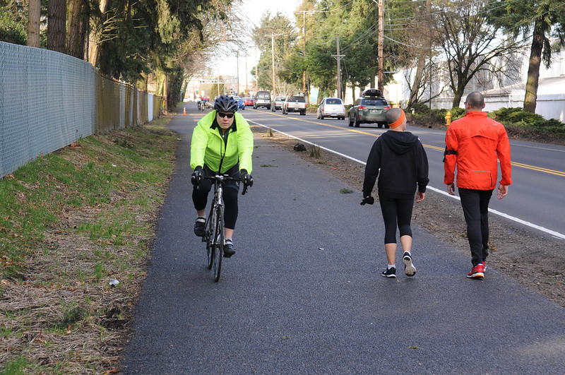
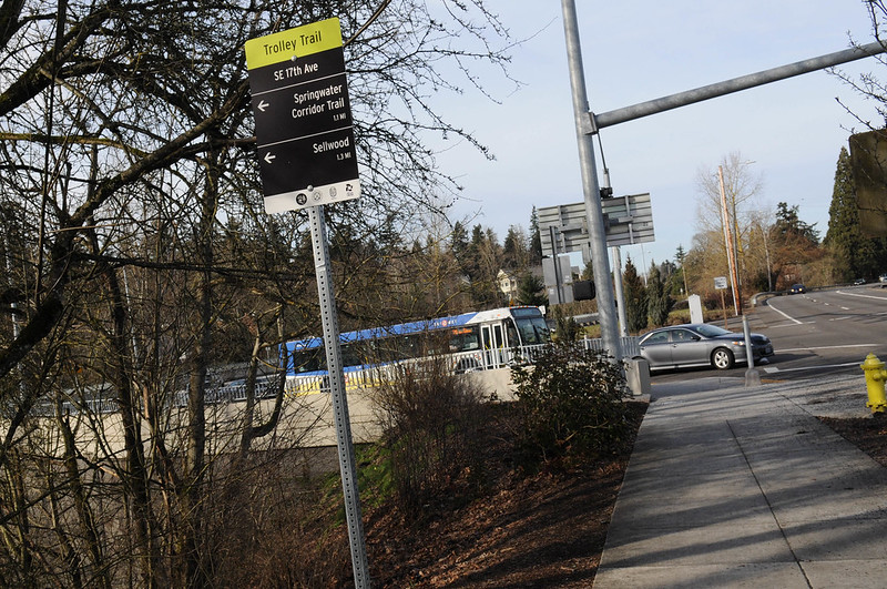
(Photo: J. Maus/BikePortland)
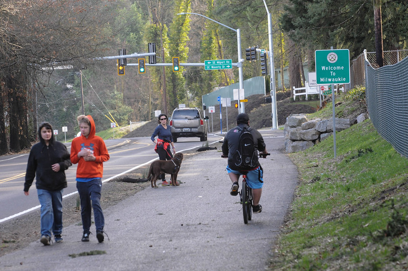
A new path now connects Sellwood to Milwaukie, making the one-mile distance between them feel much shorter.
“I’d give it a B-.”
— Matt Menely, Milwaukie bike advocate
The path opened around the start of the year but the big snowstorm put a damper on its coming-out party (unless you know how to cross-country ski). With warmer and drier temps I finally made a point to get over and check it out myself.
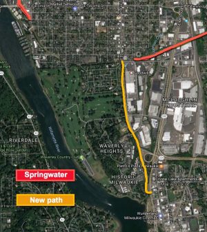
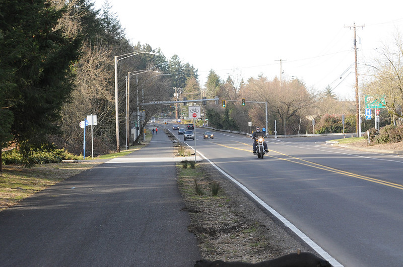
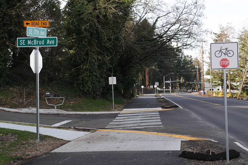
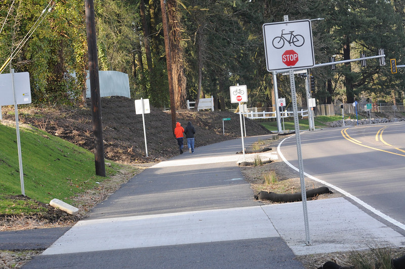
Just to refresh your memory, the $3.3 million project added a 12-foot multi-use path on the west side of SE 17th between SE Ochoco (in Portland) to the intersection with Highway 99E (in Milwaukie). As we reported in 2014 the project was funded through Metro’s Regional Flexible Funds program in 2011.
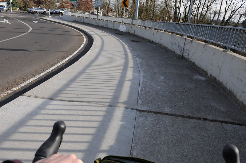
It was a good investment. The path is a vast improvement over what used to be a narrow bike lane that was often littered with debris and/or partially blocked by vegetation. This stretch of road between two cities is very sparsely populated with only a few homes and businesses. As such it always felt like sort of like a no-mans-land — one of those places where, as a bicycle user, your heart rate would jump a bit and you could never quite relax (or stop looking over your shoulder) until you go through it. Now you have a place to ride in comfort. The path also makes the paths at each end exponentially more value. I believe when it comes to significant new bicycle infrastructure, the sum is much greater than the individual parts. This path makes the existing Springwater Corridor (in the north) and Trolley Trail (in the south) much more valuable. The path also connects Milwaukie to Sellwood in both a physical and mental sense in an exciting new way. Much like a new transit line can effectively shorten the distance between two places, this path makes it possible for someone in Sellwood to hop on their bike and visit destinations in Milwaukie — and vice versa.
While the path is a huge step forward, it also misses a few key notes. Like far too many of our regional paths, it’s good — but not great.
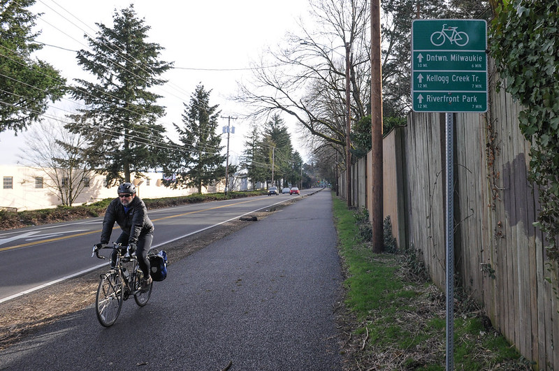
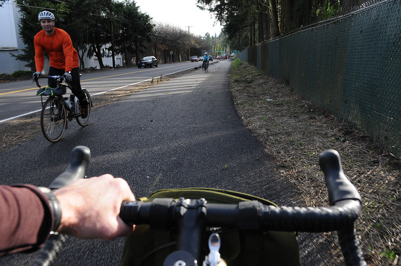
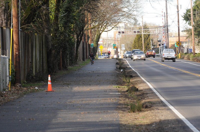
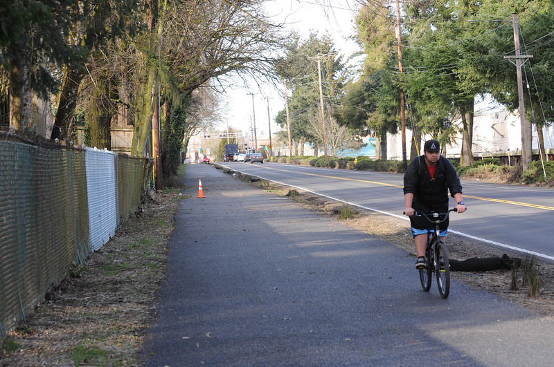
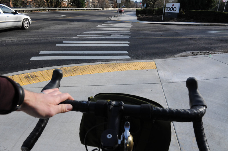
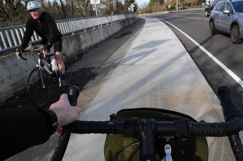
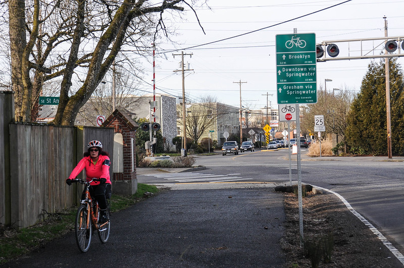
In addition to what I’ve mentioned above, the path is nice and wide. I saw people walking two abreast while a bicycle rider passed in the opposite direction and there was plenty of room for everyone. It was also nice to see new, bike-specific navigational signage to encourage people find their way to more places and explore a bit further.
Advertisement
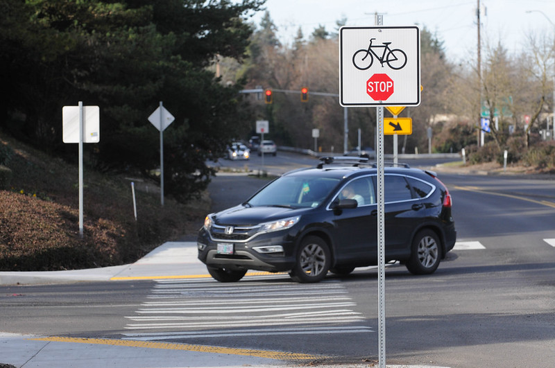
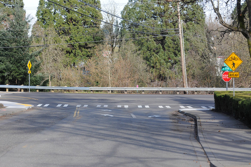
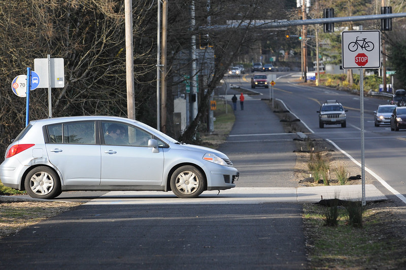
But here’s why the path doesn’t reach its full potential: it has stop signs for path users at small, private driveways; it lacks physical separation from auto traffic and it lacks safe and intuitive connections to the Springwater Corridor path and downtown Milwaukie.
Milwaukie bike advocate Matt Menely said he’d give it a grade of “B-“. I asked Menely and other members of the Bike Milwaukie group (via Facebook) what they thought of the new path. Menely said his biggest concern is the lack of separation from people driving cars 35-40 mph on SE 17th — especially at the T-intersection with Highway 224. I was surprised too. $3.3 million for a one-mile path and the only separation that exists is an unplanted dirt strip that’s just three-to-four feet wide. Menely said residents suggested jersey barriers at the 224 intersection. He’s hoping the scant vegetation fills in and/or that bollards get installed at key locations.
Other Bike Milwaukie members were excited for the path, but also laments. Cris Waller said, “The lack of a direct connection to Springwater is bad – and there’s no sign when/if that will happen. Crossing at Ochoco is dangerous.” (The City of Portland is aware of the lack of connection between this path and the Springwater. They requested funding to close the gap last fall but it was not granted.)
Ben Rousseau said, “This is a major improvement” and “Overall, I’m really glad it’s there.” But he shared similar concerns about a lack of separation from auto users and poor connections to downtown Milwaukie.
Another big issue with this path is that it comes with 4-5 new stop signs for path users that are placed on private driveways. Instead of requiring private homeowners to stop for a public path — or simply allowing all users to yield to the presence of others — these signs put the onus of stopping on path users. This is unfortunately a common practice on regional paths.
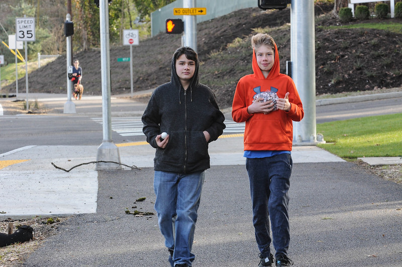
While I was out there on Sunday I ran into two young boys walking from Milwaukie to Sellwood. 13-year-old Noah said he lives a few blocks away from the path and he’s thrilled that it’s finally open. “My sister goes to Portland Waldorf School and it’s encouraged her and our family to bike more,” he said. “We used to not bike this way at all because there wasn’t a path here and the bike lane didn’t feel safe.”
Have you ridden this? What do you think so far?
— Jonathan Maus: (503) 706-8804, @jonathan_maus on Twitter and jonathan@bikeportland.org
BikePortland is supported by the community (that means you!). Please become a subscriber or make a donation today.


 Linwood Avenue path in Milwaukie")
I completely agree with the Bike Milwaukie folks: the path is a vast improvement over what was there, but it could have been designed better. It’s almost as if a rookie designed it. With all of the experience in MUP design in this area, one would expect better.
That said, my 12 year-old son rides this path to school and I feel much, much better about his safety now.
Absolutely. I’ve got two young kids (6&7) who bike, and live in Oak Grove. First time we biked home from the city, I held onto them the entire way down 17th street, as there were cars cooking past us at 50mph and virtually no shoulder to use.
Now, I’m able to let them ride it on their own, which is a massive improvement. Yes, I would prefer to not have the thing littered with stop signs the entire way, but it at least makes it so one can get all the way from my place on the Trolly Trail onto the Springwater without having to contend with major traffic.
My partner and I discovered that path while riding through Milwaukee a few weeks ago. I didn’t expect it to be there. Near the end of the Trolley Trail I was apologetically warning her about the narrow, scary bike lane that I expected us to ride in. Instead we arrived at that path, which wasn’t yet marked on Google Maps, and were pleasantly surprised.
It’s a much, much more comfortable connection to Milwaukee than the super-sketchy Springwater trail.
It looks like the Common Rush plant looks to be growing there. However, are there plans to add giant rocks for safety? Oregon grape plants?
I agree on the stop-sign thing. One of my biggest pet peeves. Stop signs on the path might be appropriate where it meets significant streets, but should never be used for driveway crossings (or even minor-street crossings).
Even if one were to accept the premise that motor vehicles should be given priority at these crossings, that can be accomplished by YIELD signs, with absolutely no effect on who gets the right of way or liability in case of a collision. In other words, no effect on the motorists whatsoever. But the difference to cyclists is huge: 1) demanding that we stop all the time for driveways with next-to-nonexistent traffic is tedious, reduces the effectiveness of the path and is just plain insulting. It sends a message that even if the bike path carries 10 times the traffic of the driveway it crosses, those few cars are still more important than we are. 2) If there’s no one coming we’re just going to ignore the stop signs anyway, further perpetuating the cyclists-as-scofflaws viewpoint.
Putting stop signs at all these locations just goes against the reality of how these paths are used. Transportation departments follow a standard 85th-percentile rule for determining speed limits: i.e., they set it at the speed that they expect 85% of car traffic to comply with. Imagine if we applied a similar rule to stop signs on bike paths, and only burdened cyclists with them at locations where 85% of us would comply with them! (e.g., at major-street crossings). BOOM! Problem solved. I’m done here. Time for lunch.
a MUP is not transportation infrastructure, it’s recreational…
That’s incorrect Spiffy. First, there’s no solid legal delineation between “recreation” and “transportation” …And that’s a great thing. IMO it’s a big mistake for anyone to create this false choice. Also you have to look at the funding. It’s from federal transportation dollars, so the facility is definitely more legally aligned with transportation than recreation. At least that’s my read of it. Same with Springwater, Waterfront Path, Esplanade, and so on. Whether city agencies or haters like it or not, these aren’t just “bike paths” — these are transportation corridors and they should be designed/built/maintained as such.
a long history of conflict on shared paths in the portland area indicates that putting Bikes on Sidewalks (BS) is a mistake. i feel very strongly that a bike facility that is not physically separated or, at a minimum, demarcated by paint is BS.
Actually, it’s not even a bike path. It’s a sidewalk. Worse yet, it’s a sidewalk on which people using bikes have several needless stop signs.
I think whoever gave it a B- grade was overly generous. I’d give it a D- at best. It’s width and adjacent obstacles mean that it doesn’t even pass California’s bike path standards; clearly it is designed with failure in mind (if significant numbers of people actually got out of their cars and used bikes, it wouldn’t function well at all). Perhaps the stop signs are to ensure that failure.
Actually, it’s a future roadway. By building the path, the city has secured the right-of-way for a future 7-lane arterial (2 travel lanes in each direction plus parking plus a turn lane), all with gas tax funding, no-questions-asked.
Oh Please, if you want to fear monger at least present a plausible scenario. The new right of way is now around 50 feet. Now I’m not transportation designer, but I feel that I have a pretty good grasp of geometry. Please illustrate to the rest of us how your imagined “7 lane arterial” is supposed to fit? Don’t worry, I’ll wait.
Sorry, I would have replied sooner, but there’s a 3-hour time difference between us and I went to bed early.
South of McBrad Ave in Milwaukie, just south of the city line, the existing ROW expands to 80 feet, and south of that it becomes virtually unlimited when it merges with McLaughlan. 7 lanes within 80 feet is very easy with 5×10 foot lanes, plus 2 7-foot parking lanes (unused), 2 6-foot bike lanes, and one side of sidewalks. Mind you, this is outside of Portland, so no vision zero and a much lower standard of design.
I’d dispute the 50 foot ROW within Portland; it looks more like 60 feet on the Portland Maps I see. However, given an unlikely scenario of them actually finding money to expand the roadway, I dare say extra ROW can be acquired if needed for most if not all of this portion of the roadway. For the 3 blocks, 780 feet, in Sellwood, certainly not on the west side where the pioneer cemetery is, but perhaps on the east side, which is part of Milwaukie, with the industrial/warehouse use, they can get another 20 feet. It’s perfectly feasible.
As a follow up, the Google maps show the portion between Waverly/Millport (Portland city line) and McBrad with heavy equipment on the west side of the roadway, having already torn up the ground presumably to put in the new pathway. The torn up area is well within property that listed as being non-ROW on Portland Maps, so Milwaukie has already started to expand the ROW to a full 80 feet or so south of Waverly/Millport.
According to Metro, the 17th Ave path was constructed with “regional flexible funds.” It was NOT gas tax. Your claim about funding is WRONG.
I’m also waiting for you to reveal the plans for making 17th Avenue seven lanes wide.
…And where does Region Flex Funds funding come from? Metro. And how do they fund it? They get it from the Feds via ODOT. Yes, it is gas tax funding. Trust me.
Umm this says:
“The minimum paved
width of travel way for a two-way bike
path shall be 8 feet, 10-foot preferred.”
http://www.dot.ca.gov/hq/oppd/hdm/pdf/english/chp1000.pdf
So, how does 12 feet width not meet these standards?
let me clarify… it’s not cycling transportation infrastructure…
sure, you could use it for that, just like I can use a parking lot as cycling transportation infrastructure, but it’s not designed for it or good for it… I’d say the same goes for auto lanes, they’re not designed nor good for cycling due to their deadly conflicts, although many cyclists make great use of them…
parks don’t get federal funding? come on now…
and you’re right, it’s not just a bike path, it’s a MUP… it’s not a bike path at all… it’s a footpath that allows bikes… just like most roads are motor vehicle maths that allow bikes…
it’s not designed to facilitate bicycle travel… it was designed to satisfy the interested-but-afraid crowd that wouldn’t use a bike lane on a road with motor vehicles…
it would be a great piece of additional infrastructure if a bike lane also existing…
many people use a MUP for their cycling transportation, but many would rather not have to use a facility designed for pedestrians…
if I had to pick between this or a bike lane then I’d have terrible choices to pick from… but I’d pick this for those that need it and then I’d just take the lane in the road because that’s closer to what I need…
“it’s not a bike path at all… it’s a footpath that allows bikes… just like most roads are motor vehicle paths that allow bikes…”
this.
I assume Spiffy is being sarcastic.
Those of us who commute daily on MUPs would beg to differ.
some people bike commute on sidewalks. are they also cycling transportation infrastructure?
Yes.
so roads with sidewalks no longer need separated bike lanes or any kind of bike facility?
removing the southbound bike lane (a crappy facility but still a bike facility) and requiring people going south to use a pedestrian facility is a step backwards when it comes to the transportation rights of people cycling. and, yes, i fully appreciate and applaud the fact that this facility is more comfortable and safer than the previous facility for the most vulnerable members of the 8/80 cohort but that does not discount the negative message it sends about cycling as a valid transportation mode. the fact that the crappy bike lane going north was restriped reinforces the idea that this is not a bike facility in any meaningful sense. essentially, one crappy bike facility was removed and replaced with a “shared” pedestrian facility (that accommodates people cycling solely by indicating that they stop at multiple intersections where pedestrians are not required to stop).
I’m not saying that. There are levels of infrastructure quality. Sometime a sidewalk is welcome where there would otherwise be nowhere else to cycle, however, I would not buy the argument that a sidewalk is an adequate replacement for dedicated cycling infrastructure. As for MUP’s, I welcome their installation because I consider them to be primarily cycling facilities that sometime have people walking in them. Many of the MUP’s I used in Beaverton when I was working out that way so rarely had people walking in them that they were de facto dedicated cycling facilities. Even many of the intercity cycleways in the Netherlands are technically shared use. Separated facilities for walking and cycling are obviously the gold standard, but the city is so unwilling to build those kind of facilities, that I’m willing to sometimes have to ride around a person rather than have to share any space with motor traffic.
i seem to recall that you were critical of the tilikum shared path even though it has bike symbols, bike-specific green crossings, and bike signals.
Yes but my complaints were not because it is a MUP, but because it was a poorly-designed MUP. It was simply not designed for cycling speeds, and all the crossings are confusing and create unnecessary conflict.
i find it ironic, that you are fine with a recreational that essentially does nothing to cater to transportation cycling because you are willing to blow 10 stop signs. imo, this is not particularly different from a fast cyclist preferring an in-road bike lane because it allows them to “take the lane”. i think most people do not want to blow stop signs and/or take the lane. we should build facilities that encourage the majority to cycle rather than building them for slow recreational riders, “scofflaws”, or “scorchers”. another critical point is that anyone running these stop signs would be fully liable if they are hit by someone exiting the driveway. the bike lane that was removed put the liability solely on the person exiting the driveway.
typo: i find it ironic, that you are fine with a recreational facility (e.g. trail) that does…
” the bike lane that was removed put the liability solely on the person exiting the driveway.”
And how, legally, does this handing off of responsibility work exactly?
Soren, I am only fine with it because I have lost faith that our local agencies are capable of building a quality cycling infrastructure network in a timely manner. Under our current political climate, I find it more useful to use what we get in a way that makes sense for us rather than have the state dictate how infrastructure should be used.
9watts,
someone cycling in a contiguous striped bike lane has legal right of way according to OR law. the current “cycling facility” unfairly puts the onus on the people cycling. for example, if someone cycling on this “bike infrastructure” were to hit a car exiting a driveway and suffer a life-changing injury the driver could sue them for damaging their bmw. and to add insult to injury pedestrians still have right of way.
to clarify further for 9watts: this facility has a bike-specific stop sign at every driveway (pedestrians have no stop sign {e.g. full right of way}).
Yes, yes, I get that. My question was how is it possible to go from the one (legal arrangement+physical circumstance) to the other (legal arrangement+physical circumstance)? How is it possible to saddle cyclists with this new duty? Are there other examples of changed traffic patterns where, suddenly those in cars have a legal responsibility to stop all the time that they didn’t have before? Or is this just more Car Head?
the desire of engineers and planners to slow people cycling (instead of automobiles) is the epitome of car head. bike commuting from milwaukie to portland is perfectly viable but to gain traction it has to be competitive with other modes. imo, this facility is a step in the wrong direction (i am not defending the previous facility in the least).
Soren, I agree with you 100% that the stop signs are BS and a paternalistic way to treat cyclists. I’m also saying that I plan on ignoring them.
I think it would be a mistake to interpret the stop signs as an attempt to slow cyclists. I think it is a misguided attempt to prevent crashes where driveways cross what engineers think drivers will think is a sidewalk, but where there will be cyclists traveling at much greater than sidewalk speeds.
This not an entirely irrational fear, but I think the solution is completely wrong. It should be fixed. But if your analysis leads you to the conclusion that the problem is “car heads”, it will be that much harder to fix than if you understand the actual motivation and can therefore propose alternate solutions.
” But if your analysis leads you to the conclusion that the problem is “car heads”, it will be that much harder to fix than if you understand the actual motivation and can therefore propose alternate solutions.”
There is motivation and there is a mindset that governs how we (experts) think about problems. You say we need to understand the actual motivation, but I’m more concerned with the fog of automobility that seems invariably to cloud the judgments and conceptual framings of those charged with designing these kinds of facilities. What you describe as a (perhaps innocent if also misguided) fix isn’t independent of the thing some of us call Car Head. I think we can all appreciate that the goal of preventing crashes can be approached from a variety of angles. The stop signs could in principle have been flipped 90 degrees at these locations. The fact that they weren’t points to something deeper, more pernicious than what I’d call motivation.
If you don’t know why they were pointed in the direction they were, how can you say the reason was pernicious?
I think I know why the stop signs weren’t flipped. It is the same reason this give the nonmotorized a new responsibility while minimizing inconveniences to those inside cars occurs all over the place. The reason is that those in charge reflexively assume those not in cars aren’t full transportation participants, will some day grow up and drive, and can therefore handle a minor inconvenience like this. How (un)conscious this may be isn’t I don’t think as important as the fact that it underlies this kind of physical fact.
I agree the design sucks. I just don’t know why it the engineer decided to point the signs in the direction they did. And if we’re going to get it fixed, we need to know what they were thinking, at a conscious level, when they made their decision.
My approach would be to interrogate them, their thinking, demand they explain how assigning the responsibility to stop in this unintuitive way (who is crossing who’s path?) came to be? Ask them to provide examples where this sort of potential conflict was solved in the manner they did, and in the opposite way and ask them to speak to the thinking in both/all cases they know of.
most of the driveways have stop signs for the drivers which is why pedestrians do not have to stop. the stop signs for people cycling superfluous and discriminatory full stop.
Sidewalks are not cycling infrastructure.
They are not ideal, but on some streets they do function as cycling infrastructure. I am certainly grateful for sidewalks any time I am cycling in a suburban environment that otherwise has no dedicated space for cycling.
In much of the South here, sidewalks function as cycling infrastructure and are identified by local governments as such, even for 5-foot wide sidewalks. No joke.
“not cycling infrastructure.”
Huh. That’s funny. I often use them for cycling. In many places they’re the best option. I will almost always use a bike lane when one is available, but many roads don’t have them, and many roads are dangerous for biking (see “stroads”, “death roads,” etc.). Sidewalks aren’t great, but if (as in many suburban areas) there aren’t a lot of driveways or side streets to traverse, they’re not bad either.
I recall this analogy from my SAT days:
Driving : Bike Lanes –> Biking : ______
Goldfish?
The stop sign thing. A big pet peeve of mine too. But it is much more widespread than this path. I’ve long lamented the pair of stop signs on the sidewalk that passes in front of the downtown Powell’s Books upstairs parking garage at 11th Ave. The ramp that takes those in cars into and out of the parking garage features stop signs FOR PEDESTRIANS who are walking down the sidewalk there. I’ve never understood the logic, what to me looks like blatant Car Head. Can anyone explain this?
Those stop signs are not MUTCD-compliant. Feel free to ignore them.
As for the facility, it looks like a high-quality cycleway. I’m not convinced that concrete barriers are needed – the dirt strip should offer enough separation. The path could use centerline striping though, to make it clear that it is a cycleway and not a lane for cars. And I like that it’s asphalt, rather than concrete! More like this one, please!
Thanks Adam. There it is, in Chapter 9B.03:
07 When priority is assigned, the least restrictive control that is appropriate should be placed on the lower priority approaches. STOP signs should not be used where YIELD signs would be acceptable.
Yeah, that and the MUTCD says to use a regular octagonal stop sign, not that “bike over stop” one that was used on this path.
Those stop signs remind me of the stop-bike signs that once dotted SW Garden Home Road just west of SW Oleson Road. Gone now.
Oh, those stop signs on Garden Home drove me crazy for YEARS. They’re finally gone?! Good riddance!
You are correct that they are not in the federal MUTCD. They are present in the Oregon Supplement to the MUTCD (sign OBR1-1), which states:
STOP (R1-1) signs (see Figure 9B-2) shall be installed on shared-use paths at points where bicyclists are required to stop.
YIELD (R1-2) signs (see Figure 9B-2) shall be installed on shared-use paths at points where bicyclists have an adequate view of conflicting traffic as they approach the sign, and where bicyclists are required to yield the right-of-way to that conflicting traffic.
Option:
A 30 x 30-inch STOP sign or a 36 x 36 x 36-inch YIELD sign may be used on shared-use paths for added emphasis.
Guidance:
Where conditions require path users, but not roadway users, to stop or yield, the STOP or YIELD signshould be placed or shielded so that it is not readily visible to road users or BICYCLE STOP (OBR1-1) or BICYCLE YIELD (OBR1-2) signs should be used.
Not saying that they’re great, but they are compliant with our state’s iteration of the guide. (Source: https://www.oregon.gov/ODOT/HWY/TRAFFICROADWAY/docs/pdf/oregon_supplement_mutcd_2009_edition.pdf)
I was not aware of this, thanks.
But neither are bike boxes and other green paint thrown around in Portland. Should drivers be free to ignore them?
https://mutcd.fhwa.dot.gov/htm/2009/part9/part9c.htm#section9C04
https://mutcd.fhwa.dot.gov/htm/2009/part9/part9c.htm#section9C05
There is an FHWA Interim Approval for Bicycle Boxes.
No center line should be put down because it is a path for pedestrians as well. Installing a center line would give the impression that it is only for cyclists.
Here in the Twin Cities, we have literally hundreds of miles of 10-15′ wide MUPs with dashed centerlines. Rode on 3 different such trails yesterday. Doesn’t create any confusion that I’m aware of.
Do pedestrians use this Twin Cities infrastructure a lot or do they have parallel routes (sidewalks) that they can use. On 17th this is the only option for pedestrians and there are frequently large groups of fast cyclists rolling through here which will be competing for limited space.
It’s a mix. On the Grand Rounds paths around the major lakes, creeks and rivers in the two core citiies, there’s usually a physically separate path for pedestrians.
However, most of the point-to-point paths (which are more often in suburban areas), including newer ones built in the last couple years, simply have a dashed line down the middle. Pedestrians use them at least as much as cyclists: on nice weekends you’ll see a lot of bikes, but on ordinary days you’ll probably see more pedestrians (mostly runners and dogwalkers) than anyone else.
Since when? Most shared paths I have used in Chicago had centerlines and it did not confuse people walking at all. Even some in Oregon have centerlines (usually ODOT ones).
A center line is fine as long as walkers aren’t signed/marked to stay on a narrow strip on one edge.
http://i.imgur.com/kkmRLrF.jpg
Just an FYI. All signs installed as part of a project that has Federal funding involved must be MUTCD compliant at the Federal level or in a State supplement.
They comply with Oregon signing policy and are legal: http://www.oregon.gov/ODOT/HWY/TRAFFIC-ROADWAY/docs/pdf/english_chapter_8.pdf, but I agree are not the right choice here.
“stop signs for path users at small, private driveways”
Stop signs for bike paths adjacent to roadways where thru auto traffic is also not required to stop are absolute horse hockey. The path on the south side of Marine Drive suffers from this.
Take the road.
That’s a pretty unpleasant road to take. No more so than Marine Drive, I guess, but… Drivers are used to speeding on that stretch between Sellwood & Milwaukie and they’re super impatient w/ cyclists. Agree with you about the stop signs, though.
I’ve ridden that stretch before the path, and must agree with both the praise and criticism.
If we replaced the words “path” and “driveway” with “street” and looked at traffic volume, I have a guess at which way the stop signs would face. Their orientation looks like a wink-and-nod trade of easement for liability.
Long ago, when ODOT called shared use paths “bike trails”, they were classified as streets. I’m not sure when the change was made to convert them to off-road sidewalks, but it has been to the detriment of cycling.
I think this has been talked about here, but…
is a MUP considered a “bicycle lane or bicycle path”?
to me it’s not a bicycle lane/path and it’s not a pedestrian lane/path because it’s a multi-use path…
so are bicycles obligated to use it per ORS 814.420?
oh I think it’s clearly a path spiffy. And since there’s no adjacent bike lane in the southbound direction you would technically be breaking the law if you took the standard vehicle lane — instead of the new path — in the southbound direction.
that’s why we need to abolish/edit 814.420
Jonathan: While I agree that 814.420 should be edited, I think you are wrong in your assertion that a cyclist using the roadway would be in violation.
There is also an exception in 814.420 as follows: “(2) A person is not required to comply with this section unless the state or local authority with jurisdiction over the roadway finds, after public hearing, that the bicycle lane or bicycle path is suitable for safe bicycle use at reasonable rates of speed.”
Unless there has been a public hearing and a finding that the path is suitable, I think the cyclist is free to use the road. I’m not aware of a public hearing having been conducted. Are you?
That public hearing language has been debunked in the past…. What I mean is that the project public outreach that occurred is considered to be the “public hearing” that satisfies the law. At least that’s been my understanding thus far. If someone knows differently, please share.
For further reading, check out this court case we covered back in 2006 where the City of Portland testified in court that the Bicycle Master Plan was sufficient as a “public hearing” so that any bike lanes created because of it were considered to have blanket immunity from claims of not having an individual hearing.
a reasonable rate of speed in a bike lane is different than the reasonable rate of speed on a MUP… I don’t think any MUP is designed to allow bicycles at a reasonable rate of speed due to the pedestrian conflicts. and with this path the unneeded stop signs…
as for the public hearing, there can’t be one BEFORE the path exists… you can’t tell on paper if it’s going to be safe… sure, a proposed lane might be safe, but the actual lane might not be… all the bike lanes in the city have gone through design and review and yet cyclists continue to be killed in them… they’re not safe…
I’m bummed they took that bike lane away. It would have been nice to have the path AND the bike lane for options.
Do you know if they aren’t planning to plant some trees in that planting strip between the road and the path? That might provide the separation you’re looking for. Or are they just using it as drainage/bioswale? That makes me a little worried about water management here and if the new path will ever be flooded.
yes, it’s clearly a path…
it’s not clearly a “bike path” though…
so is it legally a bike path/trail? if so then it’s also a pedestrian path/trail…
Google found this, but doesn’t really clear things up completely… https://www.stc-law.com/bikemulti/
it states that “ORS 801.160 defines “bicycle path” as “a public way, not part of a highway, that is designated by official signs or markings for use by persons riding bicycles except as otherwise specifically provided by law.”
but then it seems to complicate that with “Consequently, the rules that apply to a bicycle path are the same rules that apply to sidewalks.”…
so it’s both a bike path AND a sidewalk? that’s not helpful…
if it’s a bike path it’s not also a ped path… it’s a street restricted to non-motorized traffic…
I think I’ll just stay in the road and then challenge any ticket as an equity issue because the law forces one class of user onto inadequate facilities…
Glad to know I’m not the only one to have noticed the absurdity of those stop signs. Was that demanded by the property owners or just a laughable outcome of the public process? Nonetheless with the new Sellwood, Trolley Trail and this in just a short time the riding experience from SW Portland via Riverview Cemetery is vastly improved. Now if only MTB was possible in Riverview it could be the Gateway Green of SW w/ great access from many directions. How do we make that possible?
Just rode it today and one of those signs is for a driveway for an empty lot! Fairly silly. I don’t get how this is that different from the more eastern springwater, where stop signs are only for roads, not private driveways (Even for the big driveway for Dean innovations out by Foster.
If I had to guess, I’d say that stop signs for the drivers coming out of the driveways wouldn’t work because drivers would regularly roll into the path before coming to a stop, so they thought it would be safer to put the onus on cyclists instead.
I think you’re right, but this harks to the logic behind requiring or exhorting those of us not in cars to don retroreflective garb, not because it is our legal responsibility, but because it is hard to see out of autos under a variety of easily imagined circumstances.
= Car Head
You should probably add “Bus Head” since Trimet’s campaign is for the benefit of their drivers. But I agree that the whole concept of visual communication between road users is totally lame. Bats don’t need it, so why should we?
That reminds me, I need to get my sonar checked!
Beep beep click beep.
Yes, that’s my point.
actually the driveways still have stop signs for drivers. the stop signs for people cycling are superfluous and discriminatory.
There are no driveway-oriented stop signs apparent in the photos — do you know about them from your knowledge of the area? Also, how are the (ill-advised) bike-oriented stops discriminatory?
see image 8 and 11. the rest are not visible due to the angle.
this is major bikeway and people cycling for transportation should not have to stop because someone is exiting a business or residential area.
Is Image 8 this one?
https://www.flickr.com/photos/bikeportland/32880899315/in/dateposted-public/
If so, that’s a street crossing; if not, I’m not sure which ones you’re referring to.
semantics. a dead-end road leading to businesses that previously did not have a stop sign for bike traffic.
After the winter we have had, giant rocks are needed for safety.
I fail to see why people are complaining about stop signs across private driveways since I doubt people will obey them. I usually walk my bike across crosswalks if the sightlines are poor and/or the traffic is thick.
SE Foster and 111th near Pick N’ Pull is one such example of where stop signs on a bike trail are good to have. There is terrible visibility and I have almost killed a few Springwater Corridor users who nonchalantly pop out of the bushes and peddle across 111th without warning.
Agreed. Stop signs can be easily ignored.
Placing stop signs where the MUP crosses private driveways where there are only a handful of conflicts for an entire day teaches people to ignore them in places where stop signs are appropriate.
One of the “driveways” leads to a locked gate at a maintenance yard. I’ll bet it’s not used more than a few times per week. Placing a stop sign for bicyclists at this location is absolutely ridiculous.
requiring people biking at moderate speeds (~12-16 mph) to stop at every one of these driveways sends a clear message: cycling is not a serious transportation mode.
if people are constantly ignoring a traffic control device then there’s a lot to complain about…
Except 111th is an actual street, these driveways are not. That’s a big difference.
I think the problem is that people have been given the choice between breaking the law and making decent time. It might be totally unconscious on the part of the designers but it can feel like being framed.
This isn’t unique to this path and not unique to cycling signs. There are many places with stop signs that are unnecessary because traffic volumes are low. The locals learn that they don’t need to come to a full stop and they end up treating it like a yield sign not to mention creating contempt for the law. I say if that’s the case then why not just have it be a yield sign and then people aren’t breaking the law.
It’s human nature to ignore stupid laws. Not a failing on their part. It’s wrong to expect unreasonable things out of people.
The zone separating the roadway and new bike path also functions as a drainage facility. However, the lack of many plantings is very surprising. Maybe they will be completing additional landscape work? Adding street trees tolerant of moisture would provide a measure of psychological separation from vehicles as would an intermittent curb (to allow drainage) along the vehicular travel lane. See illustration on Bike Portland ‘Related Post’ above from January 22, 2015. I wonder why these techniques weren’t used on this project?
This is thrilling. It’s irritating too, but thrilling to have something besides what was there before (nothing)! The driveway stop signs are ridiculous. I’d like to see the connection to the Oaks Bottom/Springwater West one of these days, but I enjoy riding through Garthwick and Sellwood, too.
Noah and his friend are my favorite part of this story.
“(I didn’t ask why they were carrying an egg and a huge bag of Tootsie Rolls)”
🙂 🙂 🙂
“to have something besides what was there before (nothing)!”
the south-bound bike lane was removed.
It was not a bike lane; it was a substandard, narrow shoulder. In some locations, there was actually a curb with sidewalk that caused the shoulder to disappear.
What J_R said.
give me a break.
https://www.google.com/maps/@45.4496615,-122.6444382,3a,75y,172.48h,63.68t/data=!3m7!1e1!3m5!1sgrxbJO30YRLtq5Jx3oAHBw!2e0!5s20110901T000000!7i13312!8i6656!6m1!1e1
for the most part it was a 5 foot wide bike lane with no door zone and bike stencils. does it suck…sure. is it a better bike facility than many bike lanes in portland…definitely.
OK. How about this?
https://www.google.com/maps/@45.4585223,-122.6469414,3a,75y,189.96h,88.58t/data=!3m7!1e1!3m5!1shI8nFaUbZWvxp81NqDHIkg!2e0!5s20110901T000000!7i13312!8i6656
there are very few bike lanes in this area without these kind of gaps. this was a typical crappy in road bike lane but its still sad that transportation cycling infrastructure was removed without a replacement.
Noah is a good buddy of my son’s, and a great kid. For the greater good of the cycling community, I will investigate the back story of the egg and report back.
The guide signs are nice, but it’s a little embarrassing that Milwaukie is signing the Springwater along the northbound 17 Av. path better than Portland does. Northbound should be signed “Portland via Sellwood,” westbound Springwater as “Portland via Tillikum Crossing – Oaks Park,” eastbound as “Gresham – Boring.” And by the way, there’s no signage for the Multnomah / Clackamas county line on 17th. Maybe some community fundraising is needed for proper signs from the north end of the 17 Av. path to the Springwater and points beyond. And I agree about those stop signs. Likely there to prevent lawsuits in case of accidents.
“And I agree about those stop signs. Likely there to prevent lawsuits in case of accidents.”
Wait… what?
If the goal is to undermine the prospect of a lawsuit in case of a crash where a driveway crosses the path, how does this influence whether the signs face N/S as now, or W as some here are arguing?
The stop signs irritate me too, and they continue down the Milwaukie waterfront and all the way south to Gladstone. At the same time, it’s fairly clear that the tradeoff is safety (off-road path) for travel time and convenience (stop signs). It’s what was asked of drivers on Holgate and is at the heart of the planned Foster road diet. I can live with the tradeoff (albeit not happily) if it’s applied equally to all transportation modes.
What remains to be seen is how the path, esp. the part north of McBrod, survives next autumn. That stretch of 17th used to become a slip-and-slide every fall as leaves, water, and mud coated the shoulder. I’m hoping it’s separated enough from the automotive lanes that it won’t become a catch basin for car-blown debris, but I’ll admit to being slightly less than optimistic.
yes, the stop signs are for safety, but they’re also victim-blaming by putting the safety onus on the most vulnerable users… that’s why they fail…
So what do you propose? Encourage cyclists to blow through driveways? Put stop signs on the driveways, then make them stop again on the path?
There is a reason cycling on sidewalks is illegal and dangerous, and part of that is because crossing driveways is unsafe due to visibility and reaction time issues. And since we’re so worried about “victim blaming,” cycling fast on paths that are crossed from the side by peds or motorists is irresponsible and dangerous to peds and cyclists alike.
No one will stop for the stop signs, but I doubt that was ever any intent that anyone would. Rather, I expect the idea is to just slow people down and remind them to look and be ready to respond.
Despite the fact that the stop signs make it look like vehicles have right of way when crossing, I fully expect the vast majority will look for and yield to cyclists in motion. I already have all kinds of problems with motorists yielding to me when they shouldn’t, and it actually makes sense for them to do so on a path like this despite what signs say.
Yet again, The Netherlands has solved the problem of cycleways crossing driveways — the cycleway stays level and has priority — the driver gives way.
https://youtu.be/p_3Kad_JOLg
A few observations about the video.
First off, all the areas in the video are super wide, paved and virtually free of visual distractions so it is actually possible to check the bike path and the road at the same time — especially since all the fast threats only come from one direction. Also, both bike and vehicle traffic is light enough and speeds are appropriate for cars to wait behind the bike path until everything is clear. None of these apply in most areas here.
I can understand why most cyclists would prefer the facilities shown in the video, but I think fast cycling on such paths is inappropriate. Aside from the fact that driveways are inherently dangerous and must be crossed with caution, there is no way that path is safe for anything over MUP speeds.
Even if it were significantly wider, the cyclists should hold their speeds down. MUP riders should be expected to abruptly turn without warning so blowing by them is never a good idea. Fast riders need to be on the road, and adjust accordingly when on paths. One thing that drives me nuts is pretty much every time I’m on one of the bridges I ride regularly (Broadway, Steel, Hawthorne, Tilikum), I see cyclists blowing by peds and slower cyclists at unsafe speeds.
Protected cycleways are never meant for fast cycling, they are meant for leisurely to medium speed, which is how the majority of people would be riding if we had the cycling mode share that The Netherlands does. Most people who would be willing to cycle for transportation if we had adequate infrastructure to convince them to are not going to be cycling at high speed. Designing cycling infra for fast riding is a recipe for failure.
Agreed. Cycling infrastructure needs to be designed for who will use it the most and how they ride.
The reason I keep harping on this is I see too many people going too fast on paths and that’s not good for anyone. It’s unsafe and contributes to negative attitudes towards cyclists. People who like speed need to make sure they don’t put others at risk.
The only thing I worry about is that drivers (and even many cyclists) associate the idea of cycling infrastructure with the idea that cyclists don’t belong on the roads. I totally get why many people aren’t willing to ride regular roads. But the more of us that do, the more it encourages others to come out. This improves transport and safety for everyone and can be helpful for attracting support for cycling infrastructure.
I agree with you save for one caveat: cycling infrastructure needs to be designed for who we want to use it the most and how they will ride.
You’re designing the carrot by focus group; let’s not forget the stick.
“Most people who would be willing to cycle for transportation if we had adequate infrastructure to convince them to are not going to be cycling at high speed.”
Ah the classic “interested but concerned” trap…..
To say nothing of the path’s priority due to higher throughput, the risks of people driving on Holgate versus walking and biking along 17th are slightly asymmetrical.
” it’s fairly clear that the tradeoff is safety (off-road path) for travel time and convenience (stop signs).”
this facility is a recipe for single digit bike mode share for ever. and i say this as someone who is unabashedly opposed to both automobility and crappy in-road bike lanes.
if the city had removed the crappy 5 foot north-bound bike lane and shifted the roadway there would have been ample room for a 7 foot pedestrian path and a 10 foot bidirectional bike way. instead we have a facility that seems to have been specifically designed to maximally discourage transportation cycling.
I agree that the continued presence of the NB bike lane is puzzling. I’d be interested to know if there are legal requirements for some sort of shoulder (striped for bike lane or otherwise) that contributed to the decision.
I think it makes a lot of sense, as many faster cyclists are unlikely to cross the street to get over to the new path if they’re going North. Plus the had the space to leave the bike lane there. I’m glad to have more options.
That’s debatable.
My suspicion is that most fast northbound riders will be coming up River Rd (the best route for speedy north-south cycling in that area) and therefore meeting 17th on the west side of McLaughlin via the Milwaukie waterfront path.
Those riders *could* cross 17th before heading northbound in the bike lane, but they’d run the risk of hitting a red light. (I do that ride daily; chances of hitting the light red are roughly 50%.) It’s easier to stay on the same side of the road and take the MUP, unless the path is clearly clogged with pedestrians or slow riders.
I do that ride a ton myself, and it just depends where they’re going if they’re looking to go east on the Springwater at the North end then it makes sense to take the bike lane.
Yes it definitely won’t be used by all (or probably even most riders), but like I said options are nice.
I stumbled upon this last week on a out and back road ride to Oregon City. I love it! It makes this route so much easier and safer.
One of these days I will get out there and check out all the new stuff from OMSI south; a lot of new connections. But one that seems to be still missing is between Milwaukie and the Trolley Trail; I noticed from the Orange Line MAX the link between downtown M. across Kellog Creek under the MAX line, but what is the way across McLaughlin from there to the TT? MAX?
Re the Springwater, doesn’t this new route connect with the “missing link” along the old rail alignment, which I believe is funded?
The Trolley Trail is now connected all the way from Gladstone north into Milwaukie and directly into the 17th Ave MUP that this article is about. You should come down for a ride and check it out!
The “Missing Link” is indeed funded, and it looks like ground has broken on the railside path between SE Linn/SE 9th and SE Ochoco/SE 17th – which is the only section left that still requires riding on roads. Though honestly, it’s the lowest-stress portion of the connection, and I don’t have a problem even with my 6 & 7 year olds riding on it.
My house is on the Trolly Trail in Oak Grove, though, and at this point I can lance all the way into Portland, with that section in Sellwood being my only segments shared with cars. It’s pretty luxurious.
Jonathan- Thanks for the story on this project!
A few things worth pointing out after reading many of the comments on this story:
– There was very little public process as part of this project which is not normal in Milwaukie.
– Milwaukie had 3 different City engineers over the course of design and build out of this project, so what many of us residents hoped for early on may have gotten lost in transitions as the staff turn over happened.
– Around $900K of the original grant for this project got eaten up before the project ever broke ground due to a lot of studies that ODOT required. The Mayor stepped up big time and worked hard to find money to fill the funding gap.
– Some residents encouraged the consultants to make all the intersections of the path elevated crossings (think speed tables) to help slow auto traffic and potentially avoid collisions. Didn’t happen.
– Where 224 ends, it would have been nice to have a bit more of a barrier between the path and the auto traffic. Jersey barriers were suggested by residents.
– 17th sees a lot of fast group rides heading south and they are likely not going to take the auto lane now that the path is in place. My concern is that those large groups will not slow down or show caution for pedestrians using the path. It was suggested that signage be installed asking cyclists to yield to pedestrians because the space is limited on this path.
– A few comments on this story asked if there will be more vegetation added in the strip between the path and the road. As of now, I’m pretty sure that what you see is what you get. If the City of Milwaukie can come up with some more $, then perhaps more plants could get added, but it is likely not a high priority.
Does anyone have a link to a decent map of where this is? THe map in the story is too tiny and unlabeled for me.
Here it is on Google Maps: https://goo.gl/cr4AmZ
Bike stencil markings would be helpful.
It is not obvious it is an MUP without them.
There is no vehicular blocking pole (sorry not sure what they are officially called) at the north end coming from Portland. *Picture of women in fluorescent pink heading south with a Ford ranger pickup on the roadway behind her. I imagine it is merely a matter of time before a motor vehicle misses that slight curve and ends up using the path as a southbound vehicular lane. My hope is that a vehicle impediment device is planned at that portion. They are all over the Trolley Trail and other areas of Springwater, but are not used in this Portion of 17th.
Everyone should complain not here about the stop signs, but to the jurisdiction that installed them. They can be changed.
geeze so much whining. It’s great. It’s way better than what was there and who on a bike actually stops for stop signs anyway. All stop signs are yields unless there is a car to yield to. Then you stop.