(PBOT)
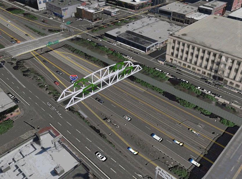
At long last the City of Portland has a clear and solid plan for building a biking and walking bridge over I-405 at Northwest Flander St. Now all they need is $3 million from the Oregon Department of Transportation to build it.
As we shared last month, the transportation bureau has submitted applications to Connect Oregon, a state lottery-backed funding program that aims to fund transportation projects that are not on highway right-of-way (and therefore can’t be paid for with gas tax revenues).
Currently pedestrians and bicyclists crossing I-405 must negotiate high-stress roadway overcrossings that include freeway interchange on and off ramps, high traffic volumes and speeds, and poor pedestrian and bicycle connectivity.
— from PBOT grant application
According to the grant application which we obtained through a public records request PBOT estimates the total cost of the Flanders Crossing Active Transportation Bridge to be $6 million. If they receive half of that from ODOT, they’ll pay for the other half with System Development Charges.
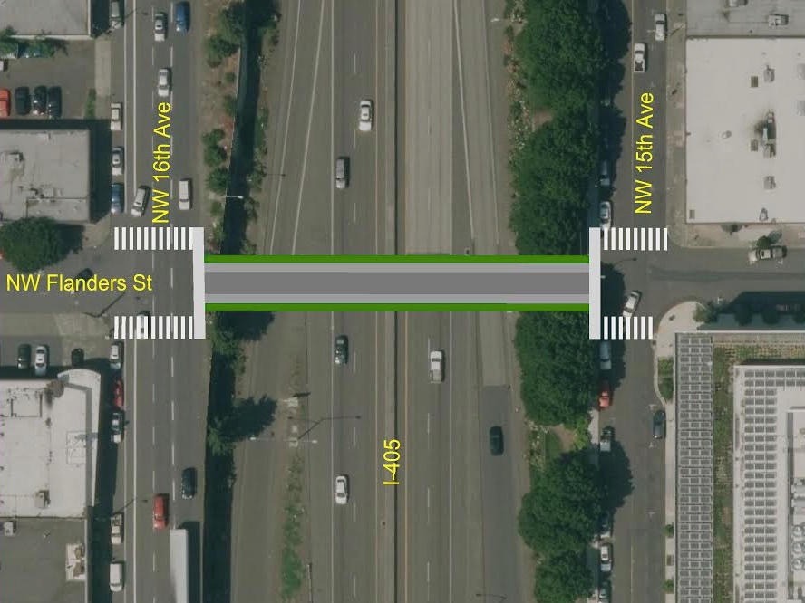
Along with the bridge, PBOT will finally build the Flanders Street Neighborhood Greenway which will create a low-stress bicycling route from NW 24th Avenue at the base of the West Hills all the way to the lower path of the Steel Bridge and the Willamette River (PBOT has also applied for grant funding for a new bikeway crossing of NW Naito at Flanders, we’ll share more details on that next week). The new bridge would also come with new signalized crossings on NW 16th and 14th.
I-405 has long been known as a barrier to this key east-west route because of a lack of safe crossings for people on bikes and on foot. The two nearby streets — Everett and Glisan — both lack sidewalks on one side and require people to cross freeway on and off-ramps. “These high-stress crossings are enough to dissuade large segments of the population,” the city’s application states, “from choosing to walk or bike to work or other destinations in the Central City despite such close proximity.”
Advertisement
A biking and walking-only bridge over I-405 has been in the city’s plan for nearly a decade. It was mentioned in Portland’s Transportation System Plan in 2007. The Flanders Bikeway is classified in the Portland Bicyle Plan for 2030 as a Major City Bikeway.
The bridge design itself isn’t finalized, but PBOT spokesman Dylan Rivera says the leading candidate right now is a steel structure that would offer 24-feet of right-of-way.

The current cross-section under consideration would split that space up between two six-foot sidewalks and two six-foot bike lanes. Rivera said PBOT feels 12 feet in each direction will be adequate for the expected daily capacity of the bridge. According to traffic demand models, PBOT expects over 9,000 bike and walk trips over the bridge by 2035. (By way of comparison, the Hawthorne Bridge has 10-foot wide shared bike/walkways and handles about 8,200 trips per day.)
The model projects 9,135 users in 2035. That is a figure for total users: bike and pedestrian. An educated guess would suggest 2/3 of those trips would be by bike, so roughly 6,000 bike trips in 2035. For comparison purposes, you might think of the peak summer counts on the Hawthorne at about 8,000, and the peak summer counts for the Steel and Broadway, which are currently about 4,500.
One thing that will impact usage of this bridge are the 17 large employers in the immediate area and the 21,292 people they employ.
There’s one key aspect of this new Flanders Bridge that PBOT hopes makes it even more competitive in the grant process: They’ve designed it to be an emergency lifeline route in the event of a major earthquake or other emergency. PBOT engineers say it would be designed in such a way to be, “operational following the most probabale earthquake to occur within 500 years.”
Bolstering the city’s case for this project is resounding support from advocates, nearby residents and businesses. Letters of support have been written from: PBOT’s Bicycle and Pedestrian Advisory Committees, Bicyle Transportation Alliance, NW District Association, Pearl District Neighborhood Association, Old Town Chinatown Community Association, Legacy Good Samaritan Medical Center, Nob Hill Business Association, Pearl District Business Association, Pacific NW College of Art, and Vestas.
If this all sounds a bit familiar, it’s because a bridge at Flanders was first proposed by PBOT back in 2006. Former Mayor Sam Adams wanted to recycle the old Sauvie Island Bridge and place it over I-405. The project had broad support, but also detractors who claimed it wasn’t equitable to invest in the central city while east Portland still lacked basic infrastructure. The idea was ultimately shelved in 2008.
While the politics are likely to be easier this time around, the grant award is by no means a done deal. Competition is fierce as this project will compete against port, rail, marine, and other biking and walking projects around the state. ODOT received over $91 million in requests and they have only $45 million to hand out. The winners will be chosen by the Oregon Transportation Commission and announced in August 2016. Rivera said PBOT estimates if funding comes through the new bridge could open in 2019.
“It would be transformative for Northwest Portland,” he added.
This is one of five bikeway projects PBOT has applied for. We’ll take a closer look at the others next week.
— Jonathan Maus, (503) 706-8804 – jonathan@bikeportland.org


Is $3,000,000 the true price or the liar’s budget?
it doesn’t count all the money the citizens will pay in subsidies for the gas the contractors will use while building it…
The estimated price is $6 million.
PBOT says they’ll put up $3 million and they want ODOT to put up the other half.
While I do think this is a great use of funds, I question the logic of PBOT fronting $3M for this when they claim they are too broke to build protected bike lanes or other bicycle projects. Why are they suddenly finding money now? How can we get them to suddently find money for protected bike lanes?
System development charges.
Oh right, that makes sense. Can PBOT use SDC funds to build protected bike lanes, or are those funds restricted to certain uses?
Restricted to projects on the adopted SDC project list.
Agreed. This seems like another vanity project. There are two existing briges right there and all we’d need to do is build legit sidewalks and protected lanes on them – which would be less than $6M I bet. There are kids walking to school through mud next to freeway-speed traffic, but the Pearl District is going to suck down millions more in resources. Fantastic.
Developers in the pearl have paid millions in SDCs, and the developments they built have significantly increased demand on the system. What’s wrong with using money generated in the pearl to fund infrastructure in the pearl that serves people traveling to, from, and through the pearl? Isn’t that exactly how it’s supposed to work? Were you upset when the water bureau used SDCs to increase water capacity to serve the thousands of new apartments that have been built? Why is this different?
Since you seem the arbiter on what passes for wise investment in our fair city, tell me how much it would cost to retrofit those bridges so they don’t collapse in the event of the earthquake? And let me know when you convince ODOT to spend that money to retrofit the bridges with wider sidewalks and protected bike lanes.
For the uninitiated, Everett and Glisan are freight routes east of I-405. Unless you remove metered parking spots to put in bike lanes, the chances of any bike facilities on those streets is near zero.
Of course, if the highway didn’t exist, every street between 15th and 16th would be contiguous. This project is attempting to repair some of the damage that was done when this horrible highway was built.
Amen to that.
The number of Delis, Bars, Shops, Houses, and related establishments that were destroyed is horrifying. The history of that cut through interstate is almost as horrible as the north I-5 segment through north Portland to Vancouver. 🙁
unless they put a stop light at each end it’s still going to be a horrible crossing… those are a couple of the worst streets to walk on in that area…
Yes, and also, NW Flanders eastbound has an apartment buiding that obstructs the view of northbound traffic on 18th. There are near misses of bikers and pedestrians all day long there.
Well we know that at least one side will have a stoplight: “The new bridge would also come with new signalized crossings on NW 16th and 14th.”
That is both sides.
That should be joyous for involved. 405 exits onto NW 16th at Glisan and then feeds the 405 on ramp/tunnel at Everett. That stretch is gridlocked constantly. Adding signals at Flanders for this bridge will just cause more congestion and driver rage.
Great! Maybe then they’ll quit driving – or better yet, leave Portland forever, and bring their cars with them!!!!
Which is ultimately the root of the problem here – cars.
Be realistic, Eddie. USPS runs a ton of heavy vehicles along that stretch every day as does C-Tran and Greyhound and it is the only freeway feeder into The Pearl District. I fully expect ODOT to quash any consideration of funding or additional signals when the federal government and the trucking lobby gets wind of this.
I think this is great.
Absent a buffered lane on Glisan, Flanders is the next best option going west, and it really is dreadful right now: fairly high volume of traffic, lots of speeding, which is made worse by the hill as you approach 24th, and crossing 21st/23rd is never too fun. And likewise, the worst part of heading east is once you get to the I-405 overpass on Everett, so if this project comes together like they say I think it’s gonna be pretty neat. If nothing else, a vast improvement to the current situation. Please add some diverters to Flanders though 🙂
Glad PBOT applied for a grant here. Hope it all works out.
+1 on the Flanders diverters. They should be included as part of this project to create a true Neighborhood Greenway in NW.
Waste of money! You get two whole blocks of semi-calm riding/pedestrian space in an already relatively bike and ped friendly neighborhood with heavy traffic, especially during rush hours at both NW 16th and NW 13th. Honestly, if “interested but concerned” is afraid of the bridges at Everett and Glisan, crossing NW 16th will scare the bejeezus out of them. In addition, I can see lots of riders getting creamed at NW 13th and Davis since the existing stop signs are now largely ignored by riders and peds alike.
A better use of funds would be to put the aforementioned crossings on a road diet and improve the bike lanes/sidewalks. New signals were just added on both roads at NW 13th which should help calm the east/west auto traffic significantly.
Sorry. Flanders between Everett and Glisan-not Davis.
Why mess around with half measures? Let’s cap the freeway from Clay to Glisan and build a park on top!
Years ago I saw a photo of a capped freeway with a park atop it. I think it was from Germany. I think this should be the standard treatment for all freeways and “parkways”. Keep the Morlocks underground where they belong.
This image is a capped freeway in Freiburg, Germany
https://www.google.com/maps/place/Freiburg,+Germany/@47.9876467,7.8659083,3a,75y,95.57h,88.03t/data=!3m8!1e1!3m6!1s-nkpRR6cSsJI%2FU-Kqu08Xc5I%2FAAAAAAAAMzc%2F4m3RqkbsW_Y!2e4!3e11!6s%2F%2Flh4.googleusercontent.com%2F-nkpRR6cSsJI%2FU-Kqu08Xc5I%2FAAAAAAAAMzc%2F4m3RqkbsW_Y%2Fw203-h101-n-k-no%2F!7i2508!8i1254!4m2!3m1!1s0x47911b26560bd665:0x41f6bb7a5df57b0!6m1!1e1
I suspect that there are lots of them. Germans and Swill put lots of freeways underground.
Ted Buehler
Germans and **Swiss** (note to self — proofread posts before hitting the “post” button)
This looks fantastic. Will this also include bike-specific traffic signals? There’s currently no signal at that intersection and painted zebra crossings isn’t adequate enough to protect people riding and walking from motor traffic.
This is excellent news. I hope they put a stop sign on the west end for cars
Two awesome guys talked at length about this project on the Ned Flanders Pedalpalooza Ride this summer, but I can’t remember their names.
A new bike bridge built from the front steps of ODOT’s Portland headquarters. Isn’t that convenient!?!
As one of the 8-80 interested but concerned set who would get good use out of this crossing, I agree with everyone who hopes that there will be signals at both ends. That 16th Avenue crossing will be untenable without.
People like to walk next to each other. If you split the pedestrian space in half like this people will walk in the bike road. Better to have a wider sidewalk on only one side of the bike road.
People seem to manage walking fine on the Hawthorne.
People do walk on the Hawthorne – but it is stressful, especially when walking with someone(s) else. People walking get a worse level of service on the Hawthorne than people driving… well, pretty much anywhere. If we’re building shiny new infrastructure, I think we can and should do better than the Hawthorne.
If the bridge has a pedestrian sidewalk on one side only, how should it connect to the sidewalks on the abutting streets?. Will pedestrians on the other side of the street have to cross through bike traffic to get to the side of the bridge that has the sidewalk?. I agree it would be better to have a single wide pedestrian walk, but I’m not sure how it would work in practice.
Look at the second picture in the post. The bridge will be aligned with the street. The bridge is narrower than the building to building ROW, so the bridge sidewalks won’t be aligned with the sidewalks on either side. So there looks to be a pedestrian walkway or refuge or something on either side of the bridge to take pedestrians the ten feet or so north and south of the bridge to be aligned with the sidewalk. If that refuge is big enough for a few people to wait without falling into either the street or the bike lane then after crossing towards 405 pedestrians could wait a few seconds if needed before walking to the bridge sidewalk. The lights will likely be timed for a pedestrian to have a crossing time of just a few seconds more than needed to cross 15/16. So if they start crossing at the beginning of the cycle there will be just a few seconds before cars on 15/16 get a green so bikes, if there are any, will have to stop leaving the pedestrians a chance to get to the walkway side.
I wouldn’t expect the one sided walkway to produce much conflict or introduce much delay for pedestrians or cyclists. Think about how many posts there are here criticizing pedestrians for walking three or four abreast on shared paths. 6 feet isn’t wide enough for that. 12 feet is.
Maybe consider aligning the bridge not with the road, but have the 12 foot sidewalk aligned with the north (or south) sidewalk on either side. Then someone crossing towards the bridge from the south (or north) sidewalk will take an extra couple seconds to get to the bridge, further reducing the chance that cyclists will still have a green when they get there.
One problem with this idea is that depending on what the bridge railing is like it might create a shy zone that effectively narrows the bike lane a foot.
6ft is not enough? How wide are you?
When crossing Hawthorne on my bike, there are many times I need to get off the bike to pass walkers walking 3-5 abreast while they are texting or playing games on their smartphones with ear plugs/phones. I usually need to walk up behind them and tap on their shoulders. They then stop and turn glaring at me (all 3 or 4) and then I rush by, pushing the bike before hopping back on. Go figure!
The sidewalk would be grade separated on this bridge.
Great news, I hope ODOT ponies up and this bridge actuallky gets built in 2019.
It was a real bummer when this plan fell apart in 2008.
All these prices are just rounding error on the overall budgets. Send your letters of support to Novick and ODOT, and if they like what they hear additional funding will come in for similar projects elsewhere in the city.
Ted Buehler
I would like to see these same groups go on record in favor of bring the current greenway system up to modern safety standards. Johnson, Marshal and Overton need diversion every few blocks. That would bumb up the bike commuting counts a lot for much less investment.
Looking back at the City Council testimony, it seems like the only neighborhood association that came out in support of the greenway assessment was the Pearl District Neighborhood Association.
The Pearl District neighborhood presented written testimony to the City Council supporting the Neighborhood Greenways reporting, as did one of the members of the NW District Association transportation committee. The formal letter from the NWDA in support of Flanders noted our support for improving the greenway network throughout the area. When Roger Gellar spoke to the NWDA about improving our greenways about the only question asked was “how soon can you make improvements?”
That said, improving other east-west streets in the area isn’t a substitute for Flanders. Johnson dead ends at the USPS site and doesn’t connect to the waterfront. One of the main benefits of Flanders is that will provide a way for people crossing the Steel Bridge from the Eastbank Esplanade to reach the Pearl and NW (which are not only residential areas, but major employment centers). NW Marshall has the same issue, with the added complication that it dead ends at Legacy Good Sam. NW Overton is a major emergency response route, so can’t have any diverters placed on it, and as such may wind up being replaced by NW Pettygrove as a greenway. While Pettygrove would make a lovely greenway (especially with the green street improvements in the Pearl recently built by private developers), it is roughly 2,600′ north of Flanders. That’s almost as far apart as SE Ankeny and Salmon. When the city comes forward with its plans for improving the Ankeny greenway I doubt you’ll be calling for the Buckman Community Association to take a position that improvements can just as easily be made to Salmon instead.
Agreed. But for a much cheaper price (and better connectivity), we could have separated cycle tracks on the Everett and Glisan bridges, both of which can easily connect to Flanders.
Your solution does nothing to help pedestrian crossing conditions.
Once again, add the cost of retrofitting the Everett and Glisan bridges to withstand a major earthquake, and THEN tell me how much money we would save.
Truth be told, if there was a choice between protected bike lanes from Naito to 23rd along Everett and Glisan, or the Flanders Greenway I would probably choose the former. However it’s not on the table, so I’m all in on supporting Flanders. PBOT has shown zero appetite for removing parking or a travel lane on those streets east of 405. They are even requiring developers to build curb extensions that preclude a bike lane in the area currently used as parking.
Wider…
Passing on the Hawthorne really only works when there are no pedestrians, so so someone can move a bit more to the right. The raised sidewalk prevents that.
Yes, it short, but people will want to pass.
12 feet isn’t wide enough for cyclists to pass each other?
On the other hand when a homeless guy is meandering along with a big shopping cart and a couple dogs anyone going the other way or trying to walk past them will have to enter the bike lane to do so. 6-12-6 will lead to plenty of complaints on this forum a few years from now about pedestrians walking in the bike lane, and an overall more stressful experience for everyone, especially pedestrians. 12-12 with a curb between the two will prevent that.
6 feet if they put a centerline on it, or if it has high enough traffic.
Even if they paint a centerline you can bike over it. 12 feet is wide enough for 3 bikes. You think it’s important to be able to pass though. ~250 feet, if you’re stuck going 8 mph instead of 18 that’s 12 seconds of delay. When someone is pushing a big shopping cart and takes up the 6 feet path at 2 mph someone walking at 4.5 mph sees a delay of 30 seconds. 12 seconds of delay is too much for a cyclist, 30 seconds is fine for a pedestrian? No. People will walk in the bike lane to go around because this design doesn’t give them enough room to do it on the sidewalk.
Design the bridge deck a bit wider. Thirty-Two feet across would give eight feet each for all four lanes. That’s almost enough for people riding in the same direction, to pass each other safely and comfortably. Ten foot wide bike lanes would be better.
Except for the fact that currently, the view to the north and south down along the I-405, isn’t much more than that, some push outs for benches would be a thought. Eventually though, if the city did proceed with covering the highway with a park and other things, the view would be much improved.
Why do they need sidewalks at all? Sidewalks are a literal pain for everyone. While they are useful when something deadly is adjacent such as horses and cars, neither of those are present. So, is this a nod to the concrete lobby? Put the bridge down, asphalt the whole thing, put in some stripping and go to town.
Why? What is someone to do with a jogging stroller? Use the middle? Then the bikers bitch about that. What about a jogger? They don’t want to dodge walkers…
Why in the world do we need to setup segregation on the outset? Put some lanes/bollards in if it’s a big issue and move on. The Sidewalks make it heavier and thus thus the design needs to compensate for that.
Let’s keep it simple.
Shared paths are a mistake. There should always be a dedicated place to walk and stop on high volume facilities. The waterfront and hawthorne bridges are miserable on foot because this doesn’t exist.
I agree with Mark, simpler, no curbs but much more space. Why build to the minimum expected use? There are more apartments, condos and jobs coming to thi area, plan for that AND build a bit of comfort into this thing! What is up with engineers imagining everyone filing single file over bridges and along sidewalks?
Comfort for cyclists, or for pedestrians too? Getting buzzed by cyclists going 15 mph a foot away walking on the existing shared paths doesn’t count as comfortable. The sidewalk should be cobblestones to minimize cyclist intrusion. 12 feet is wide enough to pass any wheelchairs or shopping carts that use the smoother bike road.
I like the idea of cobblestone….but again…its complicates everything and tries to predict the future. Bollards are easy and paint is cheap and easy to adjust as needed. Cobblestone sucks for wheelchairs.
>Cobblestone sucks for wheelchairs.
They would be in the bike lane. Make it 10 feet cobblestones, 14 feet smooth for bike/other wheeled conveyances.
Sorry. Not a fan. We have much more pressing needs than this. Everyone knows that.
More pressing needs than a dedicated foot and bike bridge? What could be better?
I84 foot and bike bridge?
All of I-405 needs a cap.
The price tag is steep, but the best things about this project aren’t quantifiable:
*Connecting communities
*Eliminate thousands of potential right- and left-hooks
*Inspire new cyclists and reduce car trips
I would be less steep without the addition of dumb sidewalk.
This is a great opportunity for ODOT to up their Active Transpo credibility without constructing anything…just by supporting and promoting this project to the fullest.
I would be cheaper to shut down 405 and convert it to ped/biking/bus use.
Hey, one can dream.
hahaaaa. close it and open it up for development to rebuild the neighborhoods and other things the city actually needs instead of a cut through interstate!