[This post was submitted by BikePortland subscriber Colin Reis. See more BikePortlander Posts here.]
If you live in North Portland anywhere west of Denver Avenue, then you’re probably familiar with Greeley Avenue. It cuts diagonally from Arbor Lodge neighborhood through Overlook and towards the Fremont Bridge, where it meets up with Interstate Avenue. This means that if you biked south on Greeley from St. Johns or The University of Portland, the 12 blocks that you’d have to travel to get from Greeley to Interstate @ Killingsworth Avenue would be avoided entirely because of Greeley’s diagonal tilt. If you prefer direct and efficient routes, hopefully you’ve signed on by now, especially if you’re a North Portland resident. A nice bonus is that Greeley goes right through the Adidas Factory with all of its flair.

Being Overlook residents, my wife or I take Greeley on pretty much a daily basis. Yet, I have noticed that there’s rarely much bike traffic along Greeley, which is part of why I chose to profile this bike route. One thing I forgot to mention is that Greeley is located on a pretty massive hill that goes down when headed south and uphill when headed North (the Overlook neighborhood got its name for a reason). Here’s a look at downward slope heading south towards downtown.
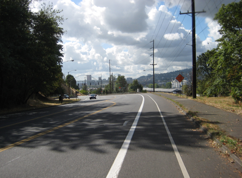
When I bike down the hill I am peddling the entire time and reach a velocity of close to 30mph. The only issue is that close to the bottom of the hill, there’s an awkward transition where bikers must cross over an entry lane where cars may be entering Greeley from Swan Island.
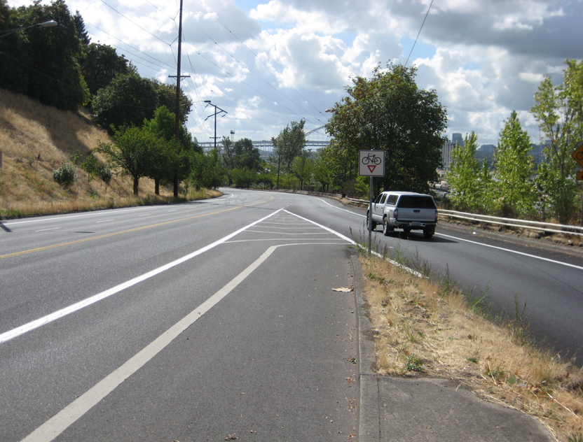
I’ve biked down this hill more than a hundred times at all hours of the day. Only a handful of times have there been a car merging onto Greeley from this lane where you see the truck merging above. Among those occasions I never had to stop, as I could simply move over into the left lane and bike in the street until the car passed me, then shift over, back into the bike lane. Some people get uncomfortable crossing this lane, but for my wife and I, it’s a non-issue. After reaching the bottom of the hill, there’s a flat straightaway with one more snafu before reaching Interstate. The two car lanes separate with the right going onto the highway and the left heading to Interstate. Biker’s are then left to their own devices to make their way onto Interstate.

Again, I rarely have to stop when crossing this part of Greeley, but the speed limit is 45mph, so some may find this intimidating. Then again, you can see a very long distance, and rarely do you have to wait long for all traffic do clear up. This Greeley route, starting from Killingsworth and ending where Greeley is swallowed up by Interstate is only 1.6 miles, but goes by in a flash. That is, so long as you’re headed downhill!


I must have the opposite normal use pattern than you. I commute to Swan Island by going up the hill in the mornings and then down in the afternoon. I find I must wait at both crossings over half the time, and when I do, I have to wait a while. The sight lines at the first crossing are pretty terrible. I feel comfortable crossing from a stop, but I hurry in case a car comes speeding up the ramp.
On the second lower crossing, I prefer to do the cross while still biking full speed when both lanes are open. I always worry someone will quickly change from the left lane to the right hand exit lane and hit me if I am starting from a stop. I see people switching lanes there all the time from my car. So I always try to wait until both lanes are clear even though I am only crossing one.
That said, Greeley is the most direct and the quickest time and effort wise from Swan Island to Downtown. The North Portland Greenway Trail can’t come soon enough. People riding bikes should have to ride in unprotected bike lanes next to 55 mph traffic (yes I know the speed limit is 45 mph there, but lets not kid ourselves that most people follow it).
I agree with this comment much more than the post author. I usually have to stop at the top crossing and at the bottom crossing it’s more like 50-50 especially before 9am. This is definitely a direct route, but as it is now, requires you to be comfortable with semis passing you at 45mph. One thing that makes it more passable is knowing that at some date in the future, it will be replaced for people on bikes with an equally direct route on the North Portland Greenway.
After nearly being hit by a motorcyclist switching from the left lane to the right lane/I-5 entrance ramp, I now wait until both lanes are clear. Sometimes I have to wait a while, but you know what, it’s worth it.
I had someone run right up from behind me (intentionally) like they were going to ram me and then slamming on their brakes to make their tires skid. I think I am only just over it now (6 months+ later).
On the plus side, a little pestering of ODOT through Twitter has kept them (mostly) from plopping their orange cones in the bike lane before weekends when I-5 has been closed for construction work.
What genius designed that bike lane crossover in the last photo? There no possible way anyone could make a 90° turn like that.
I assume someone who thought if you paint a line that offers cyclists a smooth transition across the highway ramp they might take it without realizing that where they’re initially positioned in the bike lane all the way to the right they will be invisible to any driver following a taller vehicle too close or in the lane over (eg. sedan following/behind and next to a van or truck), many drivers won’t be expecting a cyclist here (can only fix that – and even then incompletely – with far more bikes than currently use the road), and given the speed differential (posted at 45, design speed seems higher), and aggressive merging to be expected in a highway like environment at a ramp that this would be very dangerous for the cyclist. This is a place where you need to bike defensively. Sometimes that means coming to the end of the bike lane and stopping for a bit. I think the paint encourages that. When traffic allows (no vehicle in either lane) you can always make a smoother transition than is painted, there’s no curb here.
Greeley is the most terrifying stretch of road I’ve ever biked on. (and one time I accidentally biked on what appeared to be the offramp of the Fremont bridge, if that helps put it in perspective.
I’ve only ridden it once, and I was nearly forced into a grate by a semi who was more than 6 inches into the bike lane at about 45 MPH. Could have been fatal if I hit the grate.
I’m sorry to hear that so many other folks have had such terrible experiences on Greeley. Maybe I should have precluded my profile by saying that I biked all over NYC for 2 years and I’m a pretty fearless biker… Is there anybody else out there that uses Greeley happily?
Definitely not me. I go all the way over to Vancouver Street. Greeley would usually be more direct. I look forward to the day when the safest, most direct routes are the routes available for all people.
I do appreciate that you appreciate Greeley, however. As someone who spends a lot of time thinking about how infrastructure in Portland can be life-threatening and how it could be made more safe for all people, I really appreciate your perspective. Portland may have a long way to go — just this Thursday, Blumenhauer pointed out that Portland has something like 7% of all trips made by bike, which is twice the national average excluding college towns, and it was done with the same amount of money that would be budgeted to add one mile of highway — but there are so many people working as hard as they can to make Portland as safe for people on foot, on bike, etc., and do many people have done so much already to make the streets more safe.
I rarely ride on Greeley because I don’t feel safe on Greeley, (if someone drives their car into me, I’m not statistically likely to live through the crash to tell the tale) but I hadn’t ever thought about riding on that street would be like without a bike lane. I do occasionally ride on Greeley, and I want to thank you for helping me to remember to appreciate all the work that must have gone into getting that bike lane there in the first place.
I’ve been using Greeley for my commute in the exact same manner you do for about seven years with no major issues. I would say I do it more begrudgingly than happily though. The bike lane needs to be at least a foot wider on that street, and that merge with the ramp from Swan Island is ripe for a fatal collision — I witnessed a close call there just last week. I’ll still take it over N Interstate and the nightmare that N Vancouver has become though, because I’m human and prefer direct routes.
It would be cool if you could film your entire route down Greely. That would give a nice perspective.
The bike lanes on Greeley between Going and Interstate scare the hell out of me…no margin of error at all!
npGreenway (aka Friends of North Portland Willamette Greenway Trail) agreed to forego advocacy for the Ash Grove Cement Road in exchange for a realistic option thru the UPRR Albina Yard. PBOT is currently doing a cost analysis of several options, including one that would replace the existing RR bypass track just west of Greeley between N. Going and N. Russell with the Trail.
In our letter to PBOT, npGreenway insisted that this section of the Trail link to N. Greeley, so that those traveling to and from points north of Going on Greeley can use it, crossing to the nbound bike line via the existing signal.
This link would still have to cross the sbound onramp to Greeley from Swan Island, but would basically allow folks to avoid the nasty high speed section of Greeley.
Check out the latest at npGreenway.org (we have updated our website).
and stay tuned for PBOT’s report.
It will take the whole community to elevate this segment of the WGT on the regional funding priorities in order to get it built. But its a key segment for all N. Portland bike commuters as well as Swan Islanders.
Would have been great to avoid crossing the first on-ramp but the topography makes it hard and costly if it is possible. What is in the works sounds great! Thanks for all the work to get this where it is today. What help do you need to get it pushed up and built?
Reading this again after back-to-back mornings of near tragic collisions. As the peninsular neighborhoods “change” more cyclist are using Greeley. Mornings between 7ish-9ish almost always require stopping. Afternoons too.
Caution is a serious must at both yield signs. Others note above: this write-up kinda makes Greeley feel more comfortable than it is during the rush hours. The photos are not at all indicative of weekday commutes.
Utmost care is required for all Greeley riders, new and experienced. If you’re new to North Portland, ride Greeley with a friend on your first morning or afternoon. AND USE THE YIELD BOXES.