
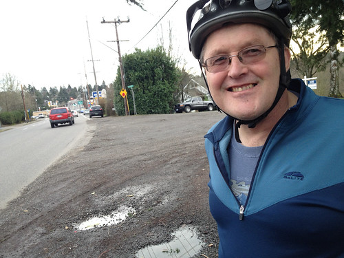
(Photo J. Maus/BikePortland)
This post is part of our Southwest Portland Week.
For a quarter-century now, neighborhood activists have been pushing to make SW Capitol Highway a nicer place to live, walk, and bike. Yesterday I joined up with local resident and Southwest Neighborhoods Inc Transportation Committee Chair Roger Averbeck for a closer look.
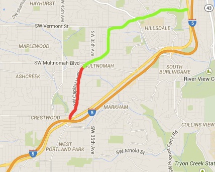
Capitol Highway is only about four miles long, but it’s a key link in the southwest Portland road network. It starts as an east-west arterial in its northern section between Burlingame and Hillsdale, then becomes a smaller, north-south thoroughfare between Garden Home/Multnomah Village and the Barbur Transit Center/I-5 in the south. In doing so it connects thousands of people to a historical business district, schools, a Metro designated Town Center, Portland Community College’s Sylvania campus, and much more.
Southwest Neighborhoods, Inc. President Marianne Fitzgerald has been working on improving Capitol Highway since 1990. She calls it, “the highest priority project for us.” The City of Portland has been chipping away at making improvements to the street since 1996 when City Council adopted the Capitol Highway Plan. That plan was updated in 2011 with the SW Capitol Highway Plan Refinement Report (PDF).
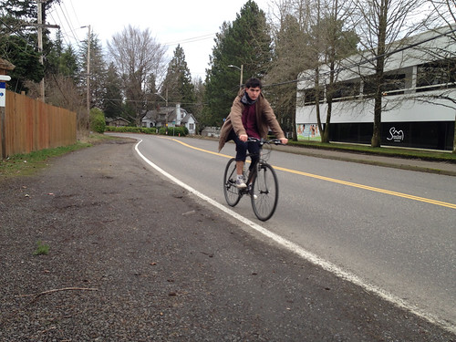
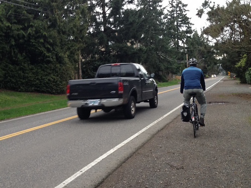
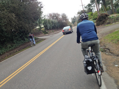
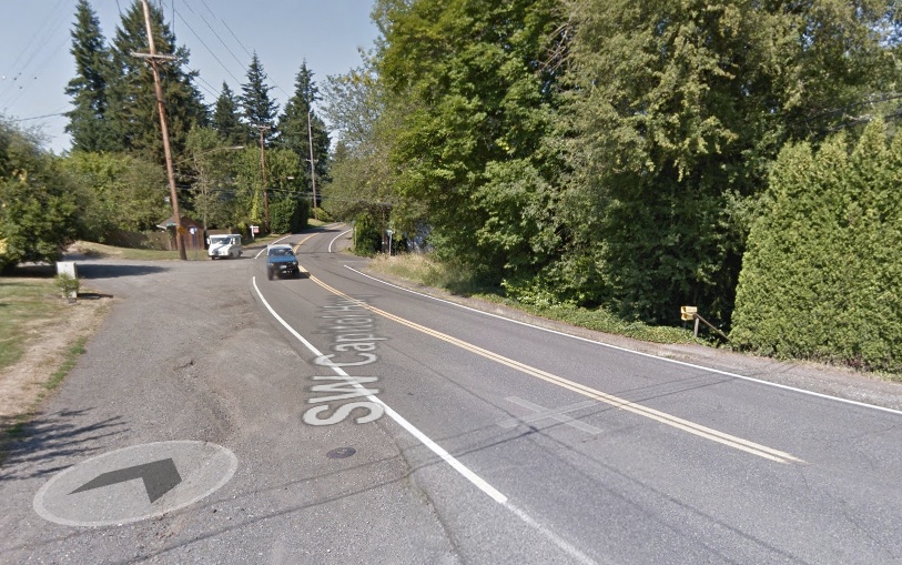
Yesterday, Averbeck and I rode a one-mile section — Garden Home/Multnomah to Taylors Ferry Rd — that still hasn’t seen any improvements. This is a particularly important section because it’s the only feasible north-south biking route in the area. Up until last year it wasn’t even marked as a bike route on the official City of Portland bike map. Now it’s listed in red, the color reserved for the most dangerous routes and which stands for, “shared roadway, very high traffic – over 5,000 vehicles per day.”
During our ride yesterday Averbeck, who lives in Garden Home, said his daughter went to school at Portland Community College just two miles away. Capitol Highway would have been a perfect route. But she didn’t ride. “She was scared to death to bike on this,” Averbeck said over his shoulder as we hugged the fog line and had drivers whizzing past us. “She would never do it.”
Averbeck is about as dedicated as volunteer activists get. He sits on numerous transportation-related committees around town, and has a particular focus on closing gaps on major arterials in southwest Portland. To him, it’s all about getting people to destinations without having to drive. When I mentioned to him how impressed I was with all the parks and greenspaces in these neighborhoods, he had an instant reply. “Yes, they’re nice, but everyone drives to them. Even from close by.”
“Here in southwest,” he continued, “you can walk your dog around the block, but people aren’t able to actually get to any destinations. So we’re trying to fix that.”
Advertisement
And the fix on this section of Capitol Hwy is obvious and straightforward. I was amazed at the existing conditions. Just a two-lane, 24-foot wide “ribbon of asphalt” (to use the City’s term from the report) with no (paved) shoulder, no sidewalks, no bike lanes, and no stormwater treatment facilities.
And here’s the zinger: The actual public right-of-way is 60-feet. That’s enough space to maintain the two standard lanes and add a bike lane and sidewalk on both sides of the street. (For reference, NE Cully Blvd, which has a protected bike lane and on-street parking, is also 60-feet in its newly rebuilt form.)
Currently on Capitol Highway, that 36 feet of unused right-of-way is full of dirt, gravel, trees, shrubs, illegal fences, and parked cars.
Check out where the telephone pole and fenceline are in the photo below. That’s how much excess right-of-way this street has…

Here’s how the intersection with SW Lobelia looks today…
And here’s a drawing of how it could look (image from PBOT’s 2011 Capitol Hwy Plan Refinement Report)…

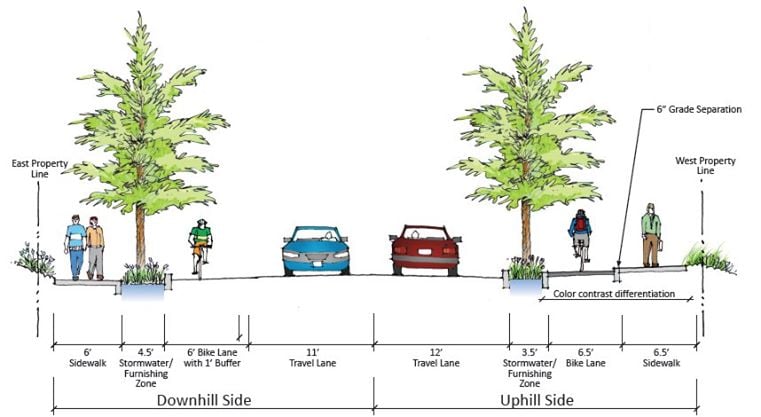
Averbeck says that at a minimum they’d like to see a bike lane in the southbound (climbing) direction and a sidewalk on both sides. But the City’s own plan drawings call for much more: bike lanes, sidewalks, and street trees on both sides.
Here’s a cross-section drawing created by PBOT:
The barrier to progress on SW Capitol Highway, as with many other major projects, is political will and funding (both of which are closely intertwined of course). The funding part is made even more challenging because of tricky stormwater treatments that are mandated by the Bureau of Environmental Services (this is a huge issue that inflates the cost of all southwest Portland projects).
According to the 2011 Plan Refinement Report, the “full build” cost for a project that would install new sidewalks and bike lanes on both sides, would cost $19.1 million — $9 million of which the City says would need to be spent on stormwater management features.
And of course there could be some pushback from neighbors who don’t want the street to change. Averbeck said he’s heard some opposing voices say they want to “preserve the rural character” of the street. “I reply to them by saying, ‘That’s nice, but you no longer have rural traffic volumes,'” he says.
This project is currently on the City of Portland’s Transportation System Plan list (to be built in “1-10 years”); but it lacks a funding commitment or a high-profile champion. Averbeck says it’s hard to create urgency for projects in southwest Portland. At a meeting this week of the City’s Bicycle Advisory Committee, its 20 members were asked to rank their top projects in the TSP. The only people that had ever heard of this project were Averbeck and Fitzgerald.
We’ll be here in Southwest all week. And join us Friday afternoon for a BikePortland Get Together and social hour at the Lucky Labrador Public House in Multnomah Village (7675 SW Capitol Hwy) from 4:00 – 6:30pm.


I’ve been wanting this project to happen for so many years now. Build it!!!
I use to live on Capitol Highway on this stretch of road. It sucked. I was nearly hit over a dozen times, not to mention the drunk driver that ran into our yard. I finally gave up and moved to SE. Thank-god-no-more-barbur
I did too. I walked that exact mile to preschool, by myself 🙂
Hard to imagine now.
I love the 3D sketch of Capitol Hwy & Lobelia. These go a long way to facilitate informed discussions, combat the fear of change, and gauge support for various options. How did Averbeck create that drawing?
“At a meeting this week of the City’s Bicycle Advisory Committee, its 20 members were asked to rank their top projects in the TSP. The only people that had ever heard of this project were Averbeck and Fitzgerald.”
That’s patently not true – I know about this project and I’m sure there are others as well. I don’t remember this question ever getting asked to the full committee; it might have been mentioned when we separated into two smaller groups, since I wasn’t sitting at Roger’s table.
In the renderings, why is the downhill bike lane not also separated by a curb like the uphill one is? Seems easy enough to swap the tree-lined “stormwater furnishing zone” and the bike lane.
Unfortunately I think someone will have to die on this stretch of Capitol before there will be enough “political will.” I don’t understand why the storm water management costs have trumped the very real public safety concerns! It’s wrong. Why can’t the city just raise our sewer and water rates some more as they have done everywhere else? How many milliions have been put into storm water management at the expense of this project. e.g. sw Multnomah blvd, and the bunkers at sw 26th and barbur. Whoever is in charge at the city has their head up their a**!
very sad
I think it is worth talking a little bit about why stormwater management has been a big priority for the city for so long: thanks to the Clean Water Act, the EPA can levy significant fines on the city when there are combined sewer overflows. The Eastside and Westside Big Pipes make a big difference in handling all but the most intense rainstorms (and they cost a lot!) but in order to make them big enough to handle every rainstorm would have probably doubled the cost. Investing in various projects to slow runoff is really the only reasonably cost effective way to address those big storms (which are likely to happen more frequently in the future).
So, how can we apply our understanding of the stormwater issue to the issue at hand?
1. Repeal the Clean Water Act to remove the threat of fines and reduce the priority of preventing combined sewer overflows. This would reduce the cost of infrastructure projects in SW. If you don’t mind sewage in the rivers, vote Republican, they’re generally in favor of this solution. (Although you might be disappointed with their stance on bike lanes…)
2. Raise sewer/water rates further and use the extra funding to increase the pot of money available for stormwater management additions to infrastructure projects. The city is reluctant to do this because there has already been a lot of backlash over the high rates we pay for sewer/water and the BES money spent on stormwater management projects was one of the poster children for “waste” in the recent campaign to form a corporate-sponsored independent water district. If you are in favor of this one, be prepared to spend a lot of time/energy/money campaigning in the dinner party/neighborhood association/Facebook/OregonLive comment section trenches to ensure that the next ballot measure to form an independent water district fails.
3. Pass a Safe Travel Act that allows some government agency or another to fine the agency responsible for a piece of infrastructure when someone gets injured or killed due to transportation infrastructure flaws. I cannot imagine such a bill even making it out of committee in any legislative body in this country.
4. Convince someone that the carbon emission reductions from providing improved non-auto transportation options will significantly reduce future heavy rainfall events and pay off over a reasonably short horizon. While I’m very much in favor of a “do all of the above immediately” approach to climate change, even I am doubtful that the math on this makes a ton of sense.
5. Wait (im)patiently for the current process to grind along and get it done eventually and/or someone to get killed in order to generate the political will to prioritize things.
I’m assuming that you’ve already disconnected your downspouts and are managing all of your stormwater on site, of course.
Jonathan – thanks for the great article! I appreciate your time to ride this important SW connection with me.
Reza is correct – it was a misquote. What I said on the ride was that only 2 Bike Advisory Comittee members that heard of Capitol Hwy are myself and Keith Liden, also a SW resident and a long time BAC member. This assumption is based on the fact that in TSP project survey that BAC members filled out in advance of Tuesdays’ meeting, the Cap Hwy project got 2 votes. Reza, if you were the 2nd vote – thanks!
After our small group discussions and my passionate plea for support for Capitol Hwy, the project ended up with 6 votes. So I appreciate that the Portland Bike Advisory Committee is increasing their awareness of cycling issues and need in SW Portland, a community with serious gaps and deficiencies in the active transportation network.
Gary – the 3 D drawing (and the cross section) are both from the 2011 Capitol Highway Refinement Plan:
http://www.portlandoregon.gov/transportation/article/353046
If they build it, people on bikes will come!
PBOT, stop the lane widening! Nobody will want to bike there with 50mph traffic lanes, no matter what bike facility you build.
Eric- the speed limit on this segment of Capitol Highway is 35 mph, not 50 mph. Other segments of Capitol Highway are 25mph (between Multnomah and Hillsdale) and 20 mph (in Multnomah Village). I hope the City will advocate for lowering the speed on this segment as well. It would make a reasonably comfortable bike street.
I hope they post it at 20 as well, but a 12ft lane is a 50mph design and drivers will be very comfortable and confident driving it at that speed (they probably drive 45 on 10-11ft lanes now.) Try 8ft or 7. We don’t need to design for fire trucks responding to 2 fires in opposite directions.
PBOT says speeding is an enforcement problem while PPB says they don’t have enough officers to do enforcement (and won’t make a stop for 10mph over anyway.) We need streets that look like streets, not neighborhood highways.
Speeding is not “an enforcement problem”, it’s a design problem. Our streets are designed, function, and appear like high-volume, high-speed streets. I live on a street that PBOT considers a “local traffic” street, yet it is striped like a high-volume street with a double-yellow centerline and a lack of crosswalks (save for a solitary zebra crossing by the high school). PBOT needs to design streets to encourage low speeds and to function as neighborhood streets, not regional highways. We can not and should not rely on the police to enforce speed limits.
My hats off to Roger Averbeck (Keith Liden too). Those guys are like energizer bunnies. They never give up. I’m an east side guy but I’m so glad they are getting some attention to their cause that they work relentlessly for.
Small businesses and the disabled would greatly benefit from this overhaul of SW Capitol Highway.
Sufficient numbers of ordinary citizens stepping up and saying to their elected officials that they want the 36′ foot, as of yet unused right of way to provide spacious bike lanes and sidewalks, can give their elected officials the political will to get the work done.
Otherwise, I expect government, eventually, will possibly consider using the currently unused right of way to add to the road, two additional main lanes to the road, and a center turn lane. If it’s really essential to meet area needs, to create such a road, I suppose it could be argued the compromise to area livability and functionality of the road for other than travel by motor vehicle, is justified. The overall consequences though, as have been demonstrated time and again when two lane country roads become transformed into five lane major motor vehicle use thoroughfares, are unpleasant to say the least.
Going downhill on Capitol highway, you get to cruise a nice little dirt single-track trail carved into the shoulder. Wee, fun!
There are TONS of roads like this in SW, ribbons of asphalt with NO shoulder at all…nothing! The white stripe is the end of the pavement. Taylors Ferry is the one that stands out in my mind. The whole area is like that.
Great story! I noticed your map of the Capitol Highway corridor ended at Barbur Boulevard. The 1996 Capitol Highway Plan actually called for improvements from Barbur Blvd (Terwilliger section) south along Capitol through Hillsdale, Vermont, Multnomah, Garden Home, and Markham segments. The Markam segment south of Barbur Blvd extended along Capitol Highway / 49th Avenue all the way to the entrance to Portland Community College’s Mt. Sylvania campus. (This is missing from your map) So…sections still to be built include Garden Home, Vermont (partially complete) and Terwilliger–probably the most difficult. And I’m not sure that bike lanes were ever built in the Markham section.