(Maps: Metro)
This post is part of our SW Portland Week.
Interstate Avenue owes its bike lanes to the Yellow Line MAX. The new Tilikum Crossing wouldn’t be standing without the Orange Line.
If the region agrees to build a high-capacity transit line through Southwest Portland to Tigard and Tualatin, major biking improvements — protected bike lanes on Barbur, a full Red Electric Trail between Hillsdale and Alpenrose Dairy, bike lanes and sidewalks on Multnomah Blvd — could be half-funded by federal grants, making them far easier to complete.
“A lot of people think this is just an HCT project, but it’s not,” Metro spokeswoman Noelle Dobson said Monday. Among other modes, she said, “it’s very much about improving bike transportation.”
But which biking improvements will get built will depend on which route a new TriMet bus or rail line would take.
For example, if the transit line runs along, Barbur then the commercial stretch of that street between Terwilliger and the Portland city limits would be largely rebuilt to include complete sidewalks, bike lanes, street trees and crosswalks.
If the line runs along Interstate 5, another option up for discussion, Barbur would only get those improvements within half a mile of the station.
And if the new line were to include a billion-dollar rail tunnel beneath Marquam Hill to OHSU and Hillsdale, a third option, Barbur might not see those major changes at all. But the Red Electric trail to Hillsdale would become much more important instead.
Here are three maps of the leading proposals for where to put a future high-capacity rail or bus line through Southwest Portland, from north to south. First, the south end of downtown Portland’s Transit Mall:
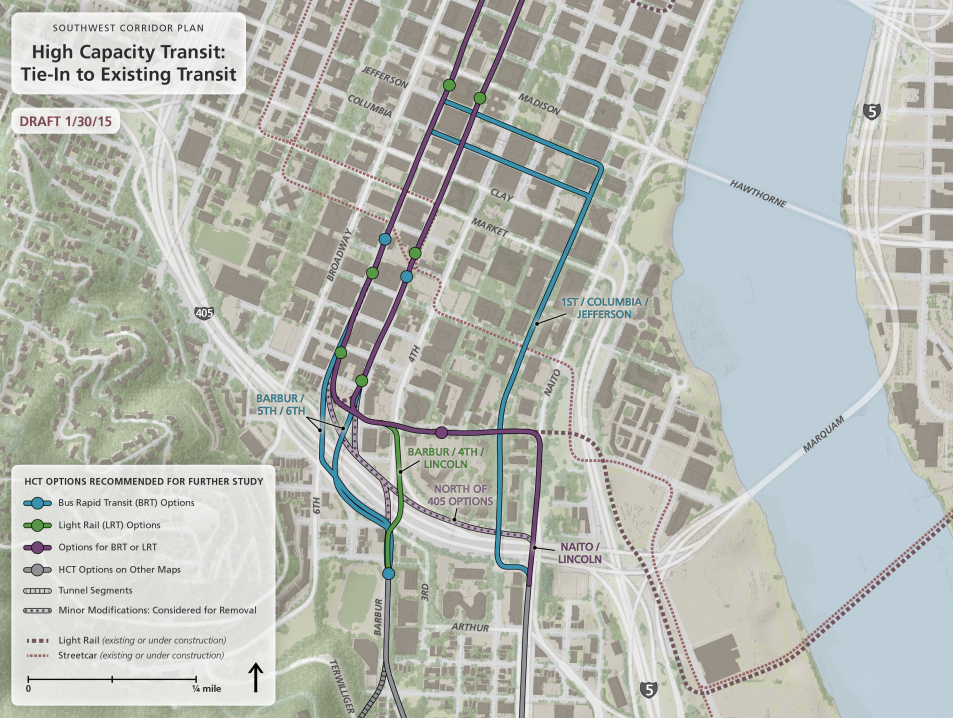
You can see, the circles represent likely transit stop locations and the colors represent different possible routes. Here’s the next step south, between downtown and Hillsdale, with two possible rail tunnel options and a choice between Barbur and Naito through Lair Hill:
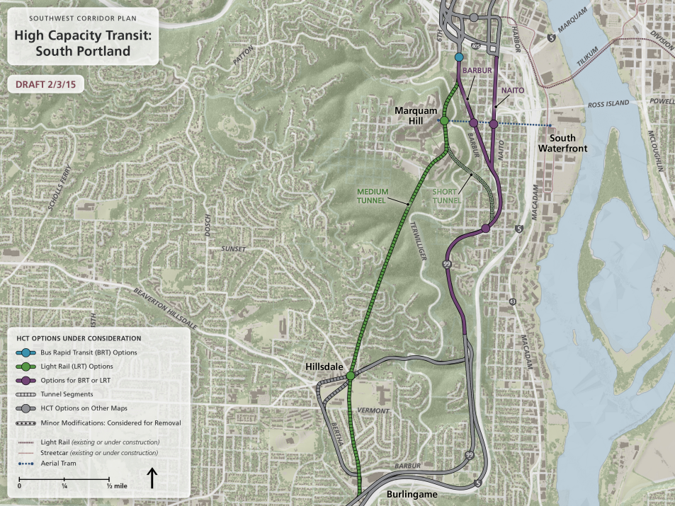
And here are the options through Hillsdale and Burlingame:
There you can see the possibilities branch out further. Notice the two different ways to reach Hillsdale, and the possible shift to run along Interstate 5, bypassing much of Barbur. (Here’s a close-up of the Hillsdale area in PDF.)
Advertisement
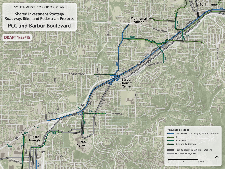
Finally, let’s look at two maps of Southwest Portland biking and walking improvements that might be associated with these projects. Here’s a set further north:
If you click through to the larger image, you can see numbers associated with each line. They correspond to the items on this list, which includes very rough cost comparisons and notes about which projects would be likely to be associated with different possible routes.
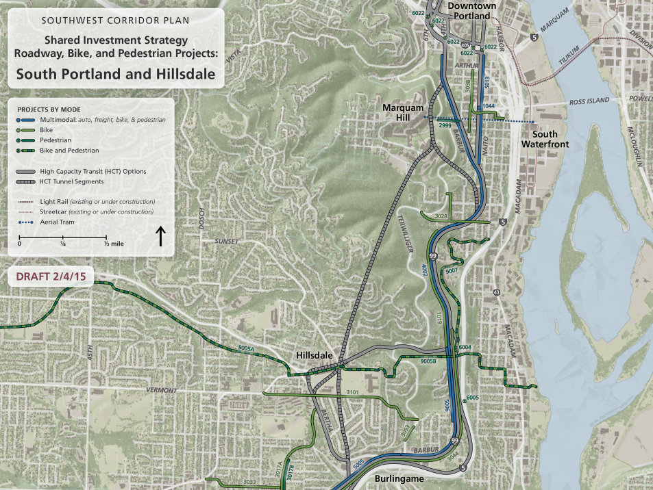
Continuing southwest along the possible project routes, here are some more biking, walking and roadway projects that could be part of a new transit line:
And here’s the list with more detail on the projects pictured.
Metro, the regional agency that is leading the planning of the Southwest Corridor project, is just beginning the process of deciding which of these routes are worth studying in detail. Dobson said Monday that the agency hopes to have a “narrowed set of alignment options and one preferred mode” by April or May of 2016.
Essentially, that means that Metro and its steering committee of mayors and other public executives will decide by next year whether to seriously pursue a Marquam Hill tunnel and/or light rail.
From there, the shortened list of routes would be studied and planned in detail to create a draft environmental impact statement of the project by late 2017. That would lead to a push for local matching funds, followed by a grant application to the Federal Transit Administration if enough local money can be found.
Actual construction wouldn’t take place for another 10 to 20 years, Dobson said. But she noted that based on public response, some projects could be put on a shorter timeline, such as five years.
Even if the new high-capacity transit line is never funded, Dobson said, the projects identified by this process have been identified as important to the area, raising their profile for other grants.
Interested in the Southwest Corridor Plan? We’ll be covering some of the possible work in more detail on Thursday or Friday. In the meantime, you can sign up for updates about the project here or email Dobson directly to share your thoughts: Noelle.Dobson@oregonmetro.gov.
We’ll be here in Southwest all week! And join us Friday afternoon for a BikePortland Get Together and social hour at the Lucky Labrador Public House in Multnomah Village (7675 SW Capitol Hwy) from 4:00 – 6:30pm.


electric self driving ubers are going to be going around picking people up and dropping them off in 20 years.
I hope this plan is looking at what to do with rail tracks and abandoned parking garages when that happens.
A rail tunnel in 10-20 years?!
Putting Barbur Blvd on a progressive* road diet would be much quicker, cheaper, and more resilient, ODOT be damned.
*as automobility dries up and blows away we keep taking more lanes for human powered modes.
I’d like an escalator from Barbur to Terwilliger. Many disabled need to visit OHSU.
SW Trails has been a leading advocate to maintain the trails from Barbur to Terwilliger, even Macadam to Terwilliger.
can’t wait to be stuck in traffic in an electric self driving uber vehicle…
The tunnel route would by far improve access and connectivity to the largest employer in the city and hard-to-access SW Portland neighborhoods, for a larger cross-section of the population, over a surface Barbur line with bikeway improvements or even worse, an elevated I-5 alignment.
Of course, this is Portland, where we seem content to settle for mediocre transit mobility outcomes.
Did you miss the Billion-with-a-B pricetag/estimate? There are lots of groovy things we might like, toys we’d like to play with, but with cost estimates like those I think it is worth considering some cheaper, quicker options as well.
Go by trebuchet!
My initial reaction to the tunnel was very positive. But studying it a bit more closely now I’m not too hot on the idea. The billion-dollar price tag is obviously a major consideration. But mostly I just feel there’s a huge opportunity lost in bypassing Barbur altogether. The tunnel is rather single purpose, but improving Barbur would have huge benefits for a wide swath of people. Furthermore, the new Orange line to South Waterfront and the Tram connects OHSO to the Max system, albeit coming from outer SW would not be straightforward, which I gather is the point of the tunnel. I suppose then the short tunnel option is actually a reasonable compromise, but at the expense of (or preservation of, depending on your POV) Lair Hill improvements.
Agreed, the short tunnel seems to be the best option.
why would the tunnel have to be single purpose? We built a ped/bike/train only bridge, why not such a tunnel? The grades would be ideal and the same elevators would provide access to the surface. Train tunnels need access tunnels for maintenance and evacuation. Just make them bike friendly.
Boy, talk about a dilemma: LRT to Pill Hill or South Waterfront?
The SW Corridor plan kind of feels like always-jam-tomorrow. There are a bazillion small improvements to be made in SW, but the SW Corridor plan is this perennial stumbling block/moving target/distant dangling carrot that scotches the little fixes. “Sure, we need a sidewalk to Capitol Elementary but let’s just table that until this until we get that SW Corridor Plan settled.”
That’s pretty much how the City of Portland has been dealing with anything land use related throughout the city: “We’ll wrap that into the comp plan.” 7 years later we realize the comp plan doesn’t do a whole lot…
Unlike downtown or the near east side of Portland, most of SW Portland is really deficient in street infrastructure. Streets are discontinuous due to topography, with a few arterials carrying the load. Sidewalks are absent. Steep grades make riding a bike on local streets really challenging.
All this makes collateral improvements for pedestrians and cyclists essential for successful mass transit development in this part of town. As TriMet is fond of saying, “every transit rider starts as a pedestrian.” Let’s also include the bike rider in our planning.
A bike and pedestrian bridge is needed over I-5 and Barbur to connect Markham School to SW 52nd Ave. All of SW Taylors Ferry needs an overhaul.
What good is the SW Corridor plan if people cannot safely walk from SW Garden Home Road to SW Barbur? I don’t want light rail.
The SW corridor should be light rail, not bus, and should not follow I-5. Nobody likes standing along a busy highway waiting for a train and less transit-oriented development will happen if the line is along a highway.
The soil is SW doesn’t lend itself well to construction. Just ask Carter & Company building a Fanno Creek bridge, a creek bridge at that.
Given the hostility shown by Tigard & Tualatin; it will be interesting to see how long it takes to make *any* progress along the SW Corridor. Federal funds are also drying up; so a tunnel (much less a long tunnel) seems pretty unlikely to me.
My best guess is that this is going to be some form of BRT along Barbur; just like Powell/Division; though the notable difference is that the folks along Powell/Division actually support transit — which is why Powell/Division has now leap-frogged SW corridor.
None of city council in Portland is required to represent certain districts; follow the money.
Lol about the bike lanes on Interstate. Yeah, they exist (some places) but it should definitely not be used as a template for other light rail related projects. Put in good infra when it’s built, otherwise it won’t get improved later (10 years & counting so far on Interstate)