Today the Portland Bureau of Transportation announced that a project first identified as a priority in their 1996 Bicycle Master Plan has finally broken ground. Yes, at long last, the 50s Bikeway is officially under construction.
PBOT accepted the $1.5 million federal grant for the project in January of 2010 and has spent the last four years completing the public process, design, and development of the project. In 2013 PBOT was forced to delay the project an entire year due to construction costs that came in higher than expected.
Here’s more about the project from PBOT’s announcement:
Advertisement
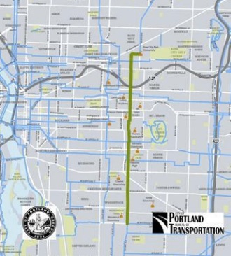
Construction is underway on the 50s Bikeway Project, a 4.3 mile safety corridor along 52nd and 53rd avenues that improves connections to eight neighborhoods, including 12 schools and seven parks, on Portland’s east side.
When complete this summer, the route will fill in a major missing link within the City’s bicycle network and better connect eight neighborhoods from Woodstock, through Mt. Tabor to Rose City Park.
As part of the project, six major street crossings along the route will be upgraded to improve safety for people walking and bicycling. Crossing improvement techniques will vary by location but will include a combination of curb extensions and medians in addition to a pedestrian flashing beacon at SE Woodstock Boulevard and a hybrid beacon at E Burnside Street.
To further improve neighborhood livability and address residents’ concerns at two key intersections, cut-through traffic will be diverted at SE 52nd Avenue and Division Street and NE 53rd Avenue and Burnside Street.
The northern portion of the route will take the shape of a neighborhood greenway on 52nd and 53rd avenues, with signage and bicycle symbols called sharrows painted on residential streets from NE Sacramento Street to SE Division Street.
On the southern portion, from SE Division Street to SE Woodstock Boulevard, the City will install six-foot-wide painted bicycle lanes on either side of 52nd Avenue. To provide the necessary space, parking will be removed from the east side of the street.
Construction is expected to take about 4 months.
Learn more about this project by browsing our coverage archives and checking out PBOT’s website.


Very exciting! I use this route about 1/2 of the time on my way home from work, and often when riding from NE to SE Portland on the weekends. It is already the nicest route to cross I-84 east of the waterfront, and with these improvement will be one of the best North-South routes in the city. I hope if will eventually continue further north. Right now it will connect to a route with bike lanes but moderately heavy traffic on NE 57th and NE Cully.
57th is pretty ugly, particularly during commuting hours. Narrow door-zone bike lane, and a lot of higher speed traffic. I have started using the adjacent neighborhood streets where I can.
About time! I am amazed that the city has left 52nd torn up between Powell and Division for 6-7 weeks (even called the pothole hotline about it)! They have started digging up the sidewalk and curbs at 52nd and Lincoln, so I assumed this project was underway. Not sure why they were telling us April/May earlier this spring. Though they said 2013, so I guess the deadline is fluid.
I’m curious about the rapid flash beacon at Woodstock, is that actually right? There is already a light there.
According to the City’s engineering plans, I think that should say rapid flash beacon at WoodWARD (not Woodstock.) At Franklin H.S. crossing, very much needed there.
Correct, that is a typo. This will be a bike focused beacon at the crossing of the Clinton-Woodward Greenway and 52nd.
Yes, that make so much more sense. Granted when I’m going by I’ve rarely seen cars not stop for pedestrians there, but it doesn’t hurt.
Selfishly, this will make going to the Portland Nursery much easier!
1996! Good thing Grunge is making a comeback.
Hey Bike Portland editors: It’d be interesting to see a time-line type article on a project like this some time in the future. Who did what/ why/how and why it takes the amount of time it does, breakdown of gains and setbacks.
I Think it’d be cool to see the breakdown of the progress of something like the North Portland Greenway (a 50-year project?), Sullivan’s Gulch corridor (never?), Multnomah Cycle track ( fast?), etc, etc.
In the first designs for the greenway portion of the 50s bikeway, PBOT showed the possible use of a green cross-bike with skipped green paint across the entire intersection. This would’ve been similar to the new green cross-bikes for bike lanes (such as eastbound off the Hawthorne Bridge and for the intersections on the Lloyd Center protected bike lane), but across the entire intersection.
Does anyone know why this design wasn’t included in the final design? I was hoping PBOT would try it out so I could push SDOT to do it up here in Seattle.
The Feds won’t pay for non-standard items. The usual MO is to retrofit, like with directional sharrows.
Is there a better map? I can’t see details on the tiny little thumbnail.
there are maps in the linked PBOT article: https://www.portlandoregon.gov/transportation/53345
this effectively makes the pavement 6′ wider in each direction… wider streets mean increased speeds…
so unless this route gets a lot of bike traffic I suspect people will start driving faster… imagine how fast and wide open this will look when it first opens…
I live a couple of blocks from Woodward and 52nd and I notice quite a bit of bike traffic, especially during commuting hours. This is a great addition to the network, I’m really enthusiastic about it. Wondering about what 52nd will look like just north of Division. There’s some paint there that looks like a precursor for an island that would restrict north bound traffic to bike, a-la Lincoln and Caesar Chavez.
Yes, I think it will just be a concrete island in the middle(allowing buses to go through) but not the edges (so not exactly like 39th and Lincoln). I can’t imagine 100% auto compliance with this design. Still think (as do many) that this is a stupid place for a bus route. (I know that it is supposedly because bus turns are limited at other intersections, but buses still struggle to make the turns around this area as is).
Spiffy, we heard similar concerns about the potential for increased speeds back in the 1990s when we first began to remove on-street parking to install bicycle lanes. We studied the issue by looking at before and after speeds on SE Bybee, SE Woodstock, SE Duke, SE 41st, NE Glisan, N Smith and NE Multnomah. In no case did we see any increase in speed. In general we saw a slight shifting toward lower speeds (though not enough to lower the 85th % speeds). We used this study as justification for petitioning the state to (successfully) lower the speed limit on NE 47th between Halsey and Glisan when we removed on-street parking and striped bicycle lanes there.
The theory behind why speeds do not increase is because of the striping added to the roadway. Without bicycle lanes these streets typically have only yellow center line striping and parked cars. With bike lanes the travel lanes are then defined with the striping–typically at 10-feet. This creates a visual narrowing of the travel lane and people driving respond by slowing ever so slightly. At the least, we can confidently state that we have never seen traffic speeds increase when we remove parking from one side of the street in favor of bicycle lanes.
That will be especially true on the 50s bikeway where the parking was only very lightly used on the west side of the street.
“That will be especially true on the 50s bikeway where the parking was only very lightly used on the west side of the street.”
Yep, if the parking area isn’t used, then the lanes feel like they are 20 feet wide!
Yes I had this realization tonight riding down 52nd with very little parking on the street. I think the bike lanes might actually make the car lane seem smaller.
It would be nice to do something about aggressive drivers on the section of 47th between Burnside and Stark. Many cyclists use it. There is no shoulder and no bike lane. Last month a car flipped over from going to fast during the morning commute. It’s amazing no one was killed. My wife was also clipped by a driver who didn’t stop right after dropping off our daughter at school. Fortunately she was not hurt. I and the other neighbors would like to see some kind of traffic calming measures so far all of the neighbors would be willing to get rid of our sickly street trees to put in a cycle track or bike lane in the easement.
I am working on lowering traffic volumes on 47th through a few long range routes via the Providence GNA Transportation working group, but I have not heard of any reports of problems south of Burnside on 47th. That stretch is in North Tabor, and considering the traffic volumes on 47th I am surprised there are not more problems. Realistically, with the budgets we have at PBOT, moving the curb and cycle-tracking 47th from Glisan to Stark to retrofit with bikelanes would cost upwards of $2 million and is not in the cards. We could however, as part of the long range safety improvements to the area, for a much lower cost either: remove parking the entire length and stripe bike lanes (about $50K but I am sure your neighbors would not like it) or, more politically palatable, add some fire engine friendly speed bumps. I have not priced it since these are new, but 47th would be a good candidate for them. PBOT has been testing them out on Cornell. The goal would be to move much of the traffic over to Casar Chavez and not cause any more cut through spill over to 45th or 44th while calming 47th.
If you would like to work on safety in the area I am the transportation chair for North Tabor. Fee free to e-mail me or come to our Transportation and Land use committee meetings (first Tuesday of the month) terry.dublinski at gmail.com
But would you be willing to get rid of your parking lane? I know I’m an n=1, but I ride that section everyday and haven’t had many issues in the last 3 years (granted I’m in the “strong and fearless” category I guess).
How did that car flip? I rode by it that morning, and it was right after the light? I couldn’t imagine that could happen on that street (being a bit narrow and not usually having people blasting through at 50mph).
…make that “on the east side of the street.”
What is going to happen to the bike corral at my favorite restaurant, TOAST, 52nd and Steele?
Still needs diversio at Glisan too. Everyone uses NE 53rd to drive to Providence Hospital. It’s gnarly.
I know. If you look at the traffic volumes, that intersection at Glisan southbound will be a mess the day this opens. There is not much we can do about diversion north of the Gulch since this is the only crossing between 47th and 60th, both of which are seeing higher than they should traffic volumes. We can however work towards a southbound diverter just south of Glisan past the medical center. I have been assured by the project manager that “PBOT is committed that the bikeway qualify for the 20 MPH standard.” This means, after this bikeway opens and they do traffic counts, when they numbers are significantly higher than the 1000 per day between Glisan and Burnside we will need to add diversion south of Glisan. A Planter and some paint would work nicely….we do not need anything fancy.
This would be fantastic. Thank you for your work on this.
“20 mph standar” is not the same as “under 1000 cars per day”.
No, but one of the criteria to get to the 20 MPH standard is that there is less than 1000 vehicles per day according to state law I believe. The route needs to be sharrowed and the vehicular speeds at the 85% tile have to be within a certain range (I forget the specifics). If these criteria are not met then physical changes needs to be made to the route to get it into compliance. Hence why some of our established greenways are 20 MPH then drop to 25 then return to 20…traffic counts and speeds.
The state law requires less than 2,000 vpd. It is the PBOT standard for neighborhood greenways that is 1,000 vpd or less.
Sorry…you are correct I just checked….it is 2000 cars per day. Which, 53rd north of Glisan is significantly over. Since there will be no diversion north of Burnside, this stretch will not qualify even when the 50’s bikeway is finished. Personally I find 1000 cars a day to be MUCH better. All relaxing greenways are at that level, without complete calming 2000 is just too busy for children or the inexperienced to feel comfortable.
are we then getting into semantics of a “greenway” versus a “bikeway”?
The two most crucial parts of this greenway that distinguish it from other greenway designs:
1) At division and 52nd northbound traffic is limited to buses and bikes.
2) At 53rd and Burnside, North and Southbound turning is restricted.
I’m not sure why PBOT was liberal (2) with divertors here, and has been reticent to use them elsewhere, but I welcome this decision.
Greenways such as Michigan (rendered useless by traffic in parts), Clinton and Ankeny would be vastly safer should PBOT decide to add divertors in strategic locations.
Clinton and Ankeny have not yet been constructed to Greenway standards.
Are there any plans to improve the intersection where Clinton St. crosses 50th St.? The Clinton Street Bike Boulevard Project called for curb extensions and crosswalk markings here, but when the project was complete the city said those improvements would be delayed and implemented as part of the 50s Bikeway. A picture of the improvements at Clinton & 50th can be seen on the Clinton Street project page:
https://www.portlandoregon.gov/transportation/article/313680
Yes, I’d love to hear about this! That crossing is quite uncomfortable, especially given how fast people start racing down the hill driving northbound on 50th.
Awesome, now if only PBOT would do some work in SW Portland outside of downtown….
Like, maybe, SW Multnomah, or Vermont, or Maplewood?