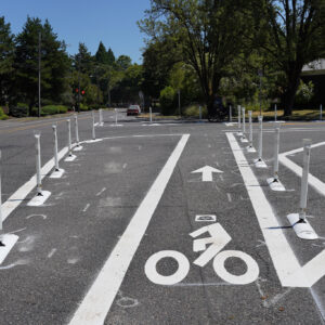
A new pair of buffered bike lanes across Lombard Street in Northeast Portland will improve both work and fun trips to the Columbia River area this summer.
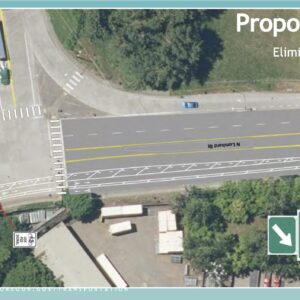
The crossing will uses the bridge at 33rd Avenue to link the river and slough, as well as nearby port, airport and retail land, to the rest of the city. It also bears traffic on 33rd across a series of railroad tracks just north of Lombard.
Motivated by a resident’s call to 503-823-SAFE one year ago, the Portland Bureau of Transportation measured traffic on the bridge and concluded that the four-lane crossing was carrying only 400 motor vehicles at its peak hour, far below the street’s 1900-vehicle capacity.
“We could easily convert a traffic lane into a buffered bike lane without increasing traffic congestion,” PBOT spokeswoman Diane Dulken explained Wednesday.
The new bike lanes across the bridge are seven feet wide with two-foot buffers. The general travel lanes are 11 feet and 14 feet, respectively.
The lane work started in late April, and we’ve already seen several happy comments from users. Ryan Hashagen, who also operates the cargo trike and pedicab business Portland Pedals, wrote that he hopes it “will make getting to the slough and river much safer.”
Dulken said the change is a testament to the importance of using the city’s street safety hotline, 823-SAFE, to report issues of all sorts.
“We evaluate every single call we get,” she said.


Awesome!
I’ve never ridden in this area, but I can’t figure out how one would navigate the north end of this configuration. I could see looping around from SB 33rd Dr. onto EB Columbia for a short distance and then up onto the bridge over 33rd Ave., but going NB? How would you get to (the assumed destination street of) NB 33rd Drive?
It’s a slightly difficult merge after you gain a lot of speed going downhill (with the exit from westbound Columbia to northbound 33rd), but thankfully there aren’t many vehicles that use that exit. The northbound route through that area is here: bit.ly/1kOjE9m
Ah. That merge at the bottom of the NB ramp is what I was curious about.
Its a bit of a weird bridge intersection, but basically continues 33rd over both Lombard and Columbia.
Northbound on 33rd, it allows you to continue North on 33rd over Lombard and Columbia to continue on 33rd and access Marine Drive. Southbound on 33rd, it brings you back over. You have the option to access as well Columbia, but Northbound is a difficult merge (on bike or in car).
Note that the “buffered” bike lanes comprise maybe 50 or 75 yards total and kind of come out of nowhere and disappear. Northbound 33rd North of Columbia has a standard bike lane. Southbound 33rd South of Columbia has no bike lane, but a wide roadway.
I regularly ride south on 33rd from the river, and the new bike lane is great. It makes merging from Columbia back onto 33rd far less stressful. Good job, PBOT.
“Motivated by a resident’s call to 503-823-SAFE one year ago…”
Wow! I need to make some phone calls.
I just saw this last night on the way home. Cool that they did it!
The only reason this is happening is that there was no parking for anyone to complain about losing.
Or any more business owners to dog pile on.
That’s great news – I’ve done that crossing a few times in the past, always thought it could be improved upon. Thanks PBOT!
Is this only on the 150 foot long bridge itself, or does it extend 1 block to the south?
The buffered bike lane is just on the bridge. At the point where the old setup of 2 standard travel lanes had merged into 1 (shown here: bit.ly/1nsaG5v), there is now a sharrow just past the end of the buffered bike lane alerting motorists that bikes may be on the road. Much better situation than before! 🙂
Thanks! I updated Google Maps. Anyone want to update Open Street Map?
Are they using a better quality paint for the added stripe this time around?
Because on Beaverton-Hillsdale Highway, the extra stripe of paint that PBOT put down last fall to create buffered bike lanes is nearly worn off. Now in a lot of places we’re back to the old striping again.
Update: PBOT came around and re-striped the buffered bike lanes on Beaverton-Hillsdale Highway this week, and I think the width of the buffer is slightly more consistent than the first time around too. Still paint, though, and not thermoplastic. And of course still only within the city of Portland, so we still have to squeeze into a 20″ wide bike lane in front of Key Bank, just outside the city limits.
From the Google Maps, it almost looks like you could now sneak around the back of the Humane Society (
11thsidewalk -> 14th -> Argyle) and head over to 33rd to make the dreaded Columbia + Lombard crossing into Concordia with barely a block’s worth of travel on Columbia proper. I’ll bet kitty would be happy with that…You could, but it would be easier to walk across Columbia in the (unmarked but legal) crosswalk right in front of the Humane Society at 11th, and then travel south on 11th, again crossing Lombard in the (marked!) crosswalk before reaching the neighborhood streets.
http://goo.gl/maps/wGg00
I rode this yesterday and it makes the crossing a lot easier to navigate! Thanks PBOT. There are now only a couple of pinch points on the northern stretch of 33rd (both directions) where you’ll want to wait for a break in traffic and take the lane.
Getting from 33rd to the Marine Dr. trailhead is also still unnerving as you’re doing essentially a u-turn through a few different motor vehicle lines of travel.
It’s still not a route I’d encourage an 8 year old to ride, but it’s getting better.