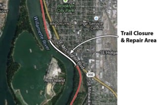
A full closure of the Springwater path at
Ross Island will start October 7th.
Ross Island will start October 7th.
I’ve got a few new details on construction projects that will impact key biking routes in the coming days, weeks and months. This post is part of an ongoing effort (similar to our post on September 10th), to keep you informed of street closures, bicycle detours, and so on. Your on-the-ground knowledge is very valuable, so if you know of detours not mentioned below, or if you have special tips about alternate routes, feel free to share in the comments.
For now, let’s get started on the advisories…
- Portland Parks & Recreation has just announced firm dates for their re-construction of a portion of the Springwater Corridor Path that eroded away back in March 2012. Beginning October 7 and ending November 15, a portion of the trail between milepost 1.5 and milepost 1.75 (about one mile south of OMSI) will be closed from 9am to 4pm each Monday through Friday. There will be no public access to that section of trail during construction hours.
- Reader Dave B. wrote in this morning about a project on the Eastbank Esplanade that is re-routing people on bicycles off the popular path. The work is due to a reconstruction project at the fire station just north of the Hawthorne Bridge. “The detour routes traffic up Main, through the parking lot, and then back down Madison to rejoin the Esplanade just before the on-ramp for westbound Hawthorne Bridge,” writes Dave. Unfortunately, he says there are no warning signs about the detour and the suggested route has hazards that could be dangerous to some riders. Keep your head up and use caution in his area until that project is completed.
- The Portland Bureau of Environmental Services is doing a sewer project on SE 42nd at Powell Blvd. This is a popular bike thoroughfare, so BES emailed with a warning about the project. Beginning this week and lasting about one month, SE 42nd will be completely closed between SE Powell and Francis. Thankfully, people riding bicycles will be able to use the sidewalk. Expect detour signs to point the way. BES says they’ve also trimmed back trees and vegetation near the sidewalks to make it easier for bikers to pass through.
Here’s a map of the project area:

If you know of other detours and/or construction projects that impact bike routes, please let us know and/or share the information in the comments below.
 over Lombard is 'ready to go'")


That Springwater re-construction won’t affect me at all!! Pretty excited they are able to keep it open during key commuting / workout hours (at least for me).
Yea, my shift is earlier, so while I should be able to get through in the morning (northbound) before the work starts, I need to find a new way home (southbound) from OHSU to Sellwood. Guess it’s my chance to finally try out the west side of the river and head east over the Sellwood Bridge.
Watch out for the detour up onto the sidewalk on SW Moody, and be prepared to get yelled at by enraged Clackastanis on your way across the Sellwood.
Good advice. Upon further consideration, I think that I’m going to try cutting east from SE 4th to SE Division Place then crossing Powell on SE Milwaukie Ave.
“Unfortunately, he says there are no warning signs about the detour and the suggested route has hazards that could be dangerous to some riders.”
I took this detour last night, and I’m pretty sure I saw detour signs. The only hazards I remember were the large amount of junk piles being hoarded by the homeless people there.
Houseless.
It is decently marked, and even it wasn’t, I can’t imagine anyone having trouble navigating 50′ around that chain link fence (through which you can see your destination!).
No need to get the PC language police involved here.
I am not sure if this is a detour, but permanent-looking signs and arrows on painted on SE 6th indicate right-turn only at SE Stark. That puts a bike heading south on 6th on to Stark (bad) then to MLK to continue south (worse!)! Heading north is not much better. I obey traffic laws while riding, but not these! Anyone know what is going on? Hoping this is temporary.
This seems permanent to me; I have started to try to remember to ride one block east several streets before Stark. That way I am not breaking the traffic laws. It has only really bugged me to do so when a car was waiting behind me. Felt a little jerkish, but no way was I going West on Stark.
Ongoing super crappy detour at the airport way/205 interchange. Airport way bike lane dead ends in big orange cones with no signed detour.
205 bike path between Holman and Marine Dr has flaggers forcing cyclists to dismount and walk through construction zone.
NE 33rd between Columbia and Marine Dr has a huge and inconvenient but well signed detour.
The SE Center neighborhood greenway is closed at 80th today for fog sealing, I presume to as far south as Foster.
Anyone else totally unsatisfied with the new connections from Clinton across 11th and 12th Aves at the split and rail crossings? It’s all sidewalk.
I understand they are still working on the bike path that will follow the new max line from here down to 9th towards Division and on to OMSI area (current detour is all the way south to woodward and then back to division place on 8th or 6th, eventually detour will move on to 9th), but this connection across 11/12th avenues and rail crossing seems to be a complete cluster. I know there isn’t too much use of it yet, but once the construction is all finished and the Max station comes in here and there is much added pedestrian and cycling activity in this intersection, it’s going to be ugly. I imagine many more riders will start taking this route to connect with the new river bridge in 2 years, and will avoid the Ladd and Hawthorne/Clay route – it will have the big advantage of going under 99E.
Heading up Clinton from here and heading towards OMSI from Clinton are both routed onto several different sidewalk sections and a very akward crossing of 11th which relies on speeding motorists to see the cycists trying to cross both lanes of traffic as they are negotiating the curves and the tracks and the road split. Not to mention the inbound crossing of 12th, which has no help or signage. It’s an engineered cluster. And it looks to be the final design.
As we get more people riding bikes and more bike specific infrastructure I foresee that this weekly detour update may be Bikeportland.org’s most important and viewed page.
I too am affected by the Springwater Closure in at least one direction of my daily commute to Sellwood. I appreciate that Parks Dep’t recognize the need to keep it open to bike and pedestrian traffic during typical commuter hours, but for such an important connector that spans a pretty long distance, it is unfortunate that they must close it at all. If this were a car thoroughfare there is no way they would have settled for a complete closure.