(Photos © J. Maus/BikePortland)
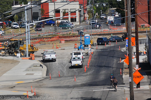
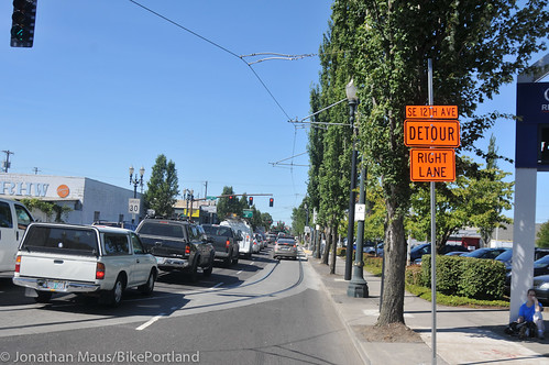
With two weeks to go for a set of major construction-related detours in Southeast Portland, they’re continuing to be a major hassle for all road users. We went out to survey the situation yesterday and we’re curious how you’re coping.
It’s all caused by TriMet construction work on the Portland-Milwaukie light rail line, which in 2015 will open light rail stations near OMSI, Southeast 12th and Clinton, Southeast 17th and Rhine, Southeast 17th and Holgate, and several points along McLoughlin Boulevard into central Milwaukie. But for the moment, as reader Ian Stude put it in a recent comment here on BikePortland, the Brooklyn neighborhood is a “desert island,” cut off from the rest of Southeast Portland by the simultaneous closures of the Union Pacific railroad crossings at 8th, 9th, 11th, 12th, and 17th Avenues (PDF of closures map).
On its detours page, TriMet promises these detours will end by 5 a.m. on Monday, Aug. 5. (The exception is the Powell pedestrian underpass at 17th Avenue, which will remain closed until a rebuilt version of the intersection opens this fall.) Until then, there are only a few ways to get around.
After we posted something about the detours on Twitter yesterday, several followers were eager to share their views:
@BikePortland Tried to get from OMSI to Clinton Theater on Division: was a MESS! To avoid Powell, had to backtrack to Clay. 1st World Probs.
— Together Gear (@TogetherGear) July 23, 2013
@BikePortland Was just there. Very confusing! Rode sidewalk down Powell to SE 13th PL & crossed RR tracks to SE 14th.
— Builder By Bike (@BuilderByBike) July 23, 2013
@BikePortland I could tell you STORIES. that intersection is terrible and the flaggers try to send families down Powell or over ped bridges
— Fiets of Parenthood (@parent_fiets) July 22, 2013
@BikePortland I got so lost trying to get from Springwater to Richmond on Sat. Should have gone to Hawthorne b/c Division Pl was a dead-end
— Abby Bush (@abbyknitter) July 22, 2013
@BikePortland I have been trying to avoid that area on my commute. I have been stuck going east on Powell to get to Clinton, which I hate.
— Brian Middleton (@aapljack) July 22, 2013
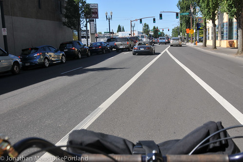
Leaving from our downtown office yesterday, Jonathan rode south past OMSI and ended up south of Division. When he asked one of the flaggers how to get north, he was directed onto a sidewalk to another flagger a few blocks away at SE Woodward and Milwaukie. That flagger said his only two options were to ride north on 99E (SE Grand Ave) or go all the way to wind his way to SE 21st (about a 1/2 mile away as the crow flies).
He opted for 99E. The signage wasn’t that great and once in the bike lane/shoulder, he found it to be full of gravel and other debris, not to mention that 99E is a very busy arterial and there is not special signage that warns road users that more people on bikes that usual will be on it (until the very end of the viaduct where there’s a permanent “Bicycles on Roadway” sign).
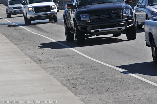
The next orange detour sign he saw was up on the sidewalk and directed him down the viaduct ramp to SE Division Place. Continuing north on 99E, the bike lane abruptly ends. Some detour signs direct users to make a dangerous right turn with poor visibility. Other detour signs direct people into the ride lane of 99E which has no dedicated bicycling space and streetcar tracks running parallel.

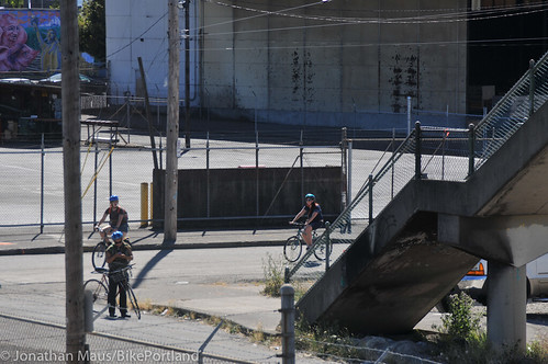
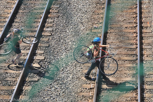
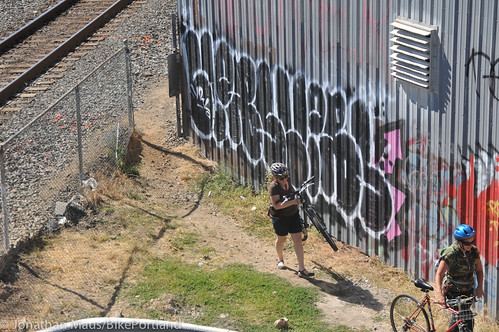
Many people on bikes are using the SE Brooklyn Street footbridge over the railroad tracks at SE 16th Ave. When Jonathan observed that area yesterday he came upon a group of four women on bikes who looked confused. Instead of carrying their bikes up and then down the bridge stairs, they snuck through a hole in the fence and carried their bikes across the active railroad tracks.
“You can do it,” one of them said, “But it’s a bit dodgy.”
Things are a bit better for the Sellwood-Moreland area and further south, which can at least access the Esplanade and eastside industrial district using the Springwater Trail along the Willamette River. Other than remaining along the river, though, the safest ways to cross the railroad in inner Southeast Portland seem to be:
- Riding on the sidewalk over the MLK viaduct, then using a ramp to access SE Division Street.
- Carrying your bike over the three-story pedestrian bridges at SE 16th and Brooklyn or SE Lafayette and 20th.
- Riding on the sidewalk over the Holgate Street bridge.
“I would hate to live in the Brooklyn neighborhood for the next few weeks. They are going to be on a desert island thanks to the Portland-Milwaukie Light Rail simultaneous closures of 8th, 9th, 11th, 12th, and 17th crossings of the freight rail tracks. Ouch!”
— reader Ian Stude
None of these is convenient, obviously.
“This is difficult to impossible with cargo bikes, or even with ordinary bikes for many women and children,” writes reader and Brooklyn resident Daniel Wright. “I took my grade schooler to New Seasons using this bridge and ended up having to carry his bike for him. I’m not sure I’d even attempt it with our Madsen cargo bike. Even on the MLK viaduct and Holgate, the street is far too dangerous for most cyclists, so you must use the sidewalk. The situation is pretty bad for drivers too, but at least they have the option of using Powell Boulevard to go under the tracks, something cyclists and pedestrians can’t do because the sidewalk has been closed there for a long time due to TriMet construction, no formal bike lane exists and drivers frequently go 50-55 mph.”
As The Oregonian reported last week, this major blockage is actually by design: TriMet and Union Pacific Railroad were worried that if each blockage happened at different times, desperate drivers might block trains as they tried to get through the remaining intersections.
“We didn’t want detours via the at-grade rail crossings because of concerns with queuing vehicles across UP tracks,” TriMet spokeswoman Mary Fetsch told the newspaper. “So the detours are designed across grade-separated crossings of the UP tracks.”
For the next two weeks, people crossing the tracks by bike and foot are suffering collateral damage.
Fortunately, TriMet says it’s keeping some people on site 24 hours a day to minimize the duration of the closure.
The great promise of this new MAX line is that, unlike the Green or Blue lines that were built along highways, it runs straight through an urban area that’s ripe for dense, human-friendly development. But for now, that’s making the construction extra annoying.
Allowing for safe and easy-to-follow detours during construction projects is an ongoing issue for the City of Portland. One way they’ll improve is by hearing your feedback. Please consider sharing your tips and experiences in the comments and if you come across unsafe situations, don’t hesitate to report it to 823-SAFE.


came down Clinton this morning and ran into the construction at 12th… went on Division and they have the road torn up so it’s a little bumpy… there were other people on bikes there so I wasn’t alone… continued on Division until Clay and hit the Esplanade…
driving on Holgate lately I’ve noticed more traffic around the new MAX area… likely people are confused and looking for through routes that aren’t packed with traffic… hint: there aren’t any…
I’ve been using the 99E detour and riding on the sidewalk rather than using the shoulder, since there’s virtually zero pedestrian traffic on the viaduct; this gets you over the track and drops you in the SE industrial district on SE Lincoln, south of SE Clay. It’s a bit confusing at the north end of the viaduct because you have to backtrack to SE Lincoln on the sidewalk (SE Grand is one way northbound at the north end of the viaduct), but still better than having to deal with the traffic on the Hawthorne viaduct exiting to southbound 99E.
I live in this neighborhood and honestly I don’t find it all that bad. Or maybe I was just prepared for it. After all, this is a MAJOR construction project so there was bound to be some short term inconvenience.
I’m very pleased with the accommodations to cyclists thus far. A difficult project to pull off without impacts, so it’s important for us all to temper our expectations. Coping skills a must, as with all aspects of life.
Under normal circumstances, I agree, but a 1 mile detour is completely unacceptable for pedestrians. Bikes, sure, but where is the sidewalk that SHOULD be open at 11th or 12th for kids, elderly, and disabled? Not acceptable, and this should be called out to hell and heaven and back as a forbidden practice in urben construction projects. Period.
I’m prepared for them to close 1 or 2 intersections at a time, not to close ALL of them at the same time.
It’s minor for most of us, but what if you’re elderly or disabled and need to get from 14th and Powell to 14th and division. That’s a 45 minute detour for a round-trip as a pedestrian.
Why is the Northern part of the Orange MAX line being put through the middle of residential neighborhoods on 17th, instead of Mcloughlin/99, but then avoids Sellwood for milwaukie (And is mostly in an industrial area.) Would be nice to see some way of fixing the bike/pedestrian bridge to get access to it easier.
It’s obviously ties to Tri-met as it goes by their garage, but is that really important for its customers (us)?
It’s following the easiest/cheapest route, which is to parallel the UP mainline through SE Portland. The only area it can’t do this is through the UP rail yard; hence the SE 17th alignment. It would have been better to send the line down 17th the whole way, but I’m sure the Sellwood neighborhood would have objected.
Why is there no signage at the end of the Esplanade indicating that there is no access to Clinton and directing riders to take SE Clay to Ladd’s Addition? I tried to follow the detour sings and wound up having to take Milwaukie to Holgate to get home—not a safe ride at rush hour.
There is signage, in fact I followed it Friday. Maybe it’s because I am a SE resident and I drive/bike through the area frequently, but getting around the construction has not been difficult.
I live in Mt. Scott Arleta, and bike through the intersection daily. I’ve never been so lost in Portland. And I wasn’t alone. Once you get on Water, there are no more bike detour signs.
My thought exactly Ben. Why not just keep people on the Hawthorne (or even take Clay) and let them get to Ladds or SE 7th/8th/9th?
I agree this is inconvenient (I take Division down to the Eastbank every few weeks (and it’s been getting harder and harder)), but not completely insurmountable. The detour they have chosen is indeed stupid, but there are other options.
Took the illegal over-the-tracks route yesterday. Freight trains have to go very slow through the project area, and blow horn every few secs. i think they go 10mph or so. Agree, signage is completely lacking. Not sure why Trimet doesn’t manage this detour better. Maybe they know it will be the last LRT line built.
Careful, kittens. I live a few blocks from those crossings and can tell you that freight trains often go quite a lot faster than 10mph … and meanwhile, Amtrak blasts through several times a day at 40-50mph. Don’t forget there are two sets of tracks, too. If there’s a train on one track, it may be blocking your view of another, faster train on the other track.
It’s not going to be the “last LRT line built”. This is a fallacy perpetuated by anti-TriMet suburbanites and Portlanders who are more American than Cascadian and have trouble wrapping their minds around heavily-subsidized public works projects, even ones that lessen auto dependence. We may see a few BRT projects spring up (probably half-assed, i.e. not fully separated), but I guarantee you that we’ll see more rail projects in the future.
Yes, because our funds for public works are just brimming over these days.
More American than Cascadian?
Don’t do it, it isn’t worth the legal risks. Union Pacific has its own police force, and will prosecute you for “first-degree criminal trespass, a class A misdemeanor punishable by up to one year in jail and a fine of $6,250”: http://www.wweek.com/portland/article-6006-union_pacific_railroad_police.html
If you choose to walk your bikes over the tracks, be careful, that’s the UP mainline for the west coast. The freight trains run relatively slowly here, but Amtrak trains can cruise by at a decent speed.
Brooklyn Street bridge makes for some good cross training and a view of the skatepark!
That is not a bike lane/Shoulder. It is a shoulder.
This area had such terrible connections before, and now almost all of those are gone:
– The 2 very high, isolated, rickety rail bridges (which, BTW, TriMet is going to demolish as part of this project)
– The Powell blvd / 17th ave underpasses (isolated, transients camping there) — both are closed
– Westbound Clinton to SE 11th southbound (CLOSED)
– Westbound Clinton to SE 12th southbound (wrong way) — CLOSED
– Westbound Clinton to Division to SE 8th southbound (CLOSED)
– Westbound Clinton to Division to SE Division Pl (wrong way) — CLOSED
– Westbound Clinton to SE 26th to Holgate Westbound (little auto visibility, high auto speeds; have to ride on sidewalk) — OPEN
Last night I was trying to get to my house near 39th & Powell to Powell & 17th. The flagger said the options were MLK viaduct or to backtrack to the ped bridge. I went for the ped bridge and there was a woman who said she didn’t feel comfortable going over the RR bridge because it was late at night and there was a drunk shirtless transient at the top hanging out. On the way home I decided skip it and go for Holgate.
What a mess!
BTW: TriMet was originally going to replace the Lafayette RR pedestrian bridge with something a little nicer, but that part of PMLR got eliminated — so now you can look forward to losing BOTH bridges and becoming 100% reliant on the Powell Blvd underpass.
Max, when I looked at the Rhine Street station plan a couple weeks ago, it appeared that at least the Lafayette Street pedestrian bridge was going to remain in place. Is that information outdated?
Looks like I’m not remembering this correctly — I went to the meeting some years ago. The Brooklyn/Gideon St. ped bridge is going to be removed. TriMet was going to rebuilt it, but it got nixxed to save money. I believe the plan was to also rebuild Lafayette, but that has also been cut. Not sure if they’re going to leave the current crappy Lafayette St. bridge in-place or not; but Gideon/Brooklyn is definitely going away. I suppose the alignment doesn’t pass under the Lafayette bridge, so seems likely that it might stay in place?
Sources:
http://trimet.org/pm/openhouse/clinton-se12th.htm
http://trimet.org/pdfs/pm/CAC/2010/September_16_2010/PMLR_Proposed_Scope_Reductions_09_16_10.pdf
Too bad about the Gideon Bridge — the Clinton station plan isn’t clear on what happens to it. I was hoping they’d rebuild it since it’s located right at the east end of the new station, but I guess not.
TriMet says:
“The one at Gideon/16th & Brooklyn will be demolished this fall (after sidewalks on Powell under the bridges are open), because it is in the future light rail trackway.
The one at Lafayette will be replaced, but construction timeline is uncertain — starting by 2016 at the latest. The new one will have its west landing at Rhine Street, to better align with the light rail station. It will also have elevators.
Replacement of both bridges was originally part of the light rail project scope, but was deferred (along with many other items) when we learned that the project was receiving less federal funding than anticipated. The Lafayette bridge is being replaced with half of the funding coming from UPRR, but there is no identified funding for the other one.”
I live in Brooklyn, and like BURR I’m mostly crossing the tracks using the 99E viaduct sidewalk, which connects back into the main SE grid right behind the Goodwill. It does more than double the length of my trip to the Seven Corners area, but with my cargo bike and/or my kid it still beats carrying everything up and down 3 flights of stairs at the Gideon or Lafayette pedestrian bridges. Despite the somewhat dangerous blind crossing mentioned in the excellent coverage above, it’s still easily the least painful route for me.
Fortunately I figured this all out before the detour started, so it hasn’t affected me too severely. The original TriMet detour map did not show the 99E viaduct as a detour for bikes, but they have now updated it to better take into account those of us who ride in and out of Brooklyn. I’ve been in contact with the TriMet people on this, and I can tell you they’ve been working hard to improve the maps and signage as things have progressed.
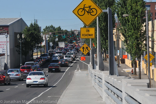
The good thing about all this is that despite the current pain, ultimately this project will greatly improve pedestrian and bike access in and out of Brooklyn. SE 17th will have bike lanes through the entire length of the neighborhood, and the Powell sidewalk under the tracks will be better. But most of all, the short stretch of Milwaukie Blvd between Powell and Clinton, which was dicey before, will be reconfigured with bike lanes, a new southbound bike box at Powell, and elimination of the dangerous car-lane merge at the Aladdin Theater. All in all things will be MUCH safer for cyclists on the main northerly route in and out of the neighborhood.
Also worth noting is that at SE 12th, the Clinton bike boulevard will be closed off to entry by cars (much like at 39th, bikes can enter but cars cannot), which should further reduce car traffic on Clinton.
I have to say this area was a major pain the other weekend. I was really in the mood for some Hotcake House and didn’t know about the closures. I rode all the way down to 11th to see it was blocked off so I figure to ride to 21st thinking I could go the back way, that didn’t work either since I didn’t want to go all the way down to Holgate and come back up. I don’t mind taking the lane but even still I had my doubts getting on Powell.
I eventually just took Clay down to SE water and came the back way to 9th, over the pedestrian bridge which goes over Powell to get to my destination.
🙂 I am coping well, thank you for asking
What would be really nice, and conform with the spirit if not actual wording of the MUTCD, would be:
(1) set out ACTUAL construction zone signage for cyclists and peds with the same turn by turn detail as is required by automobiles.
(2) frame the orange construction signs for bikes & peds in that MUTCD specified fluorescent lime green. It draws attention to both the detour, the construction and driver’s attention to the fact that bikes & peds are going to be in unexpected places.
I wish the money for that project would be spent on bike improvements all around Portland and Raleigh Hills.