highways for biking?
(Photos © J. Maus/BikePortland)
I’ve seen lots of cycle tracks in city centers; but yesterday I was curious what would happen if I just kept on riding all the way out to the suburbs. Just how far do Copenhagen’s famous cycle tracks go? After getting a bit lost (not the cycle track’s fault), I ended up riding a great loop that introduced me to two of Copenhagen’s other bikeway types: a “Green Cycle Route” and a “Cycle Super Highway”.
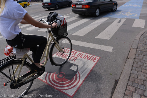
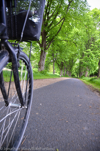
I left my little studio in Nørrebro, hopped on Nørrebrogade and headed west. While the cycle track varied in width and style from time to time, it remained pretty much in-tact for about 5 miles. Just outside Nørrebro however, I did notice my first tricky right-hook intersection. Turns out the City has noticed it too and they placed a pavement marking on the ground to warn folks about it (by the way, I’ve also noticed a similar warning on the side of trucks).
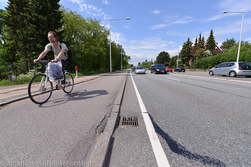
As I continued on, I was impressed that the cycle track did to0. Being used to Portland, where we might create a nice bike facility for a few blocks and then revert back to an old-school bike lane, the cycle track just kept going and going and going. For all but one little section through a grocery store parking lot that turned into a bike lane, the cycle track continued for at least five miles. And the quality and width stayed consistent throughout the trip.
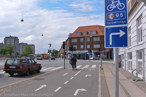
Here’s an intersection with a big right turn lane (the sign directs traffic to the newest cycle super highway route — more on that later):
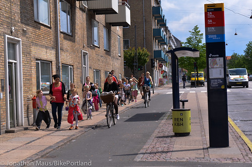
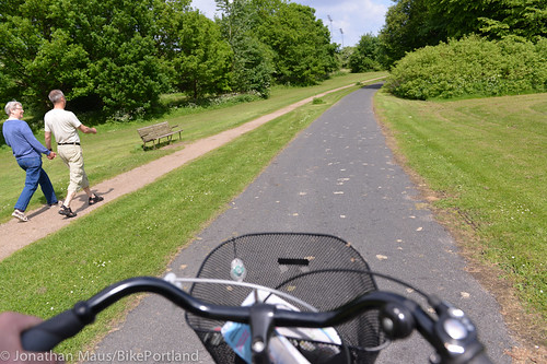
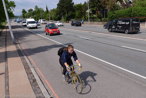
The land use changed as I got further away from the city, but the design standards of the cycle track stayed the same. I loved this scene of the bus stop, the cycle track, and the kids out taking a walk:
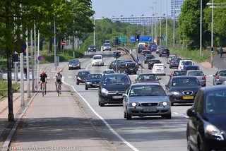
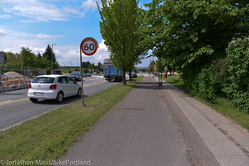
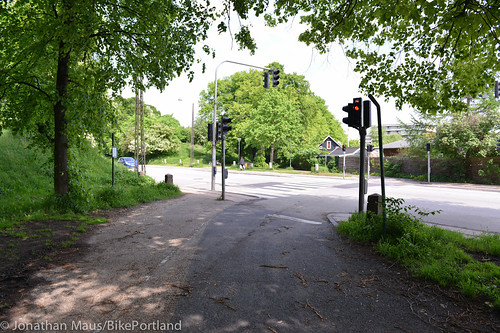
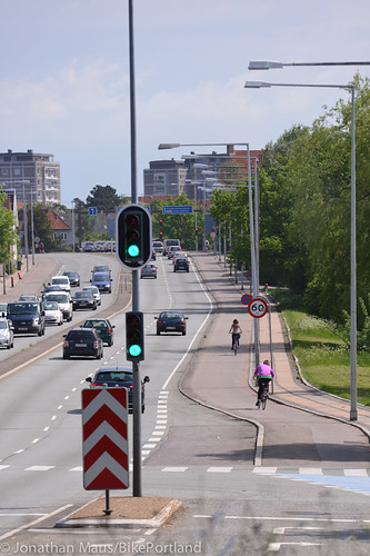
As the speed limit increases from 40 km/h (25 mph) on major city streets to 60 km/h (37 mph) further out, so too does the amount of separation:
As I reached my turnaround point, the surrounding roads began to feel more and more like what you’d see in Portland suburbs. There were larger driveways, industrial parks, and wider open spaces. The speed of cars and the size of intersections also increased. But, as a tourist beginning to feel lost, it was comforting to know that I had this piece of dedicated space where I felt safe.
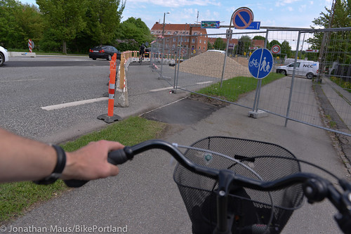
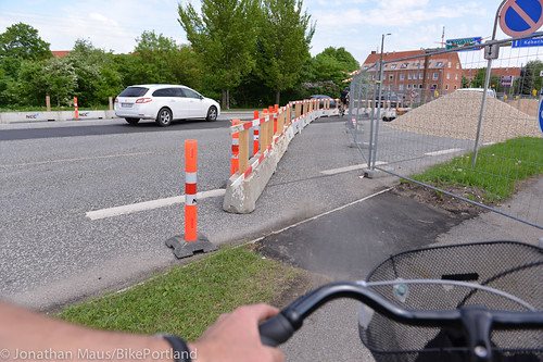
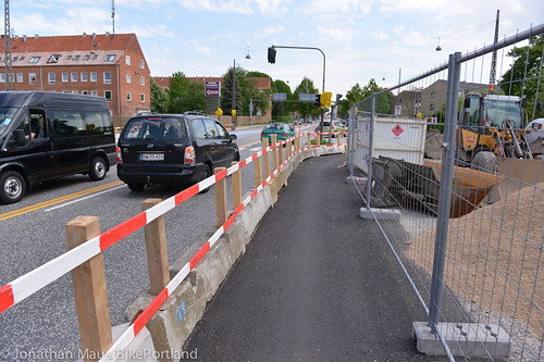
On the way back I noticed a construction project ahead. I breathed a sigh of relief when I saw that crews had created a protected bikeway detour around the site:
Not wanting to go back the same way I came, I hopped on a “Green Cycle Route” — Copenhagen’s name for an off-street path intended mostly for recreational use. What a great connection this was. Smooth pavement and a separate (dirt) path for people to walk on so I didn’t have to worry about constantly ringing my bell at other path users:
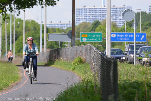
When the path came to a cross-street, I was glad to find a signalized crossing and a painted crosswalk:
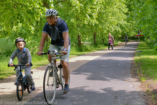
A few turns later I came across this scene, which really epitomizes what paths like this are all about:
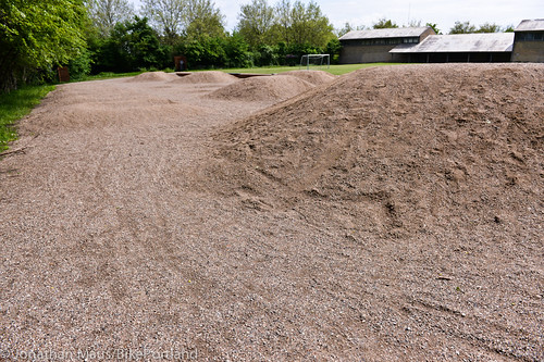
Adjacent to the path was a ton of green space, little trails to explore and places to enjoy lunch at a picnic table. At one point I rode by a grade school and noticed this little dirt pump track!
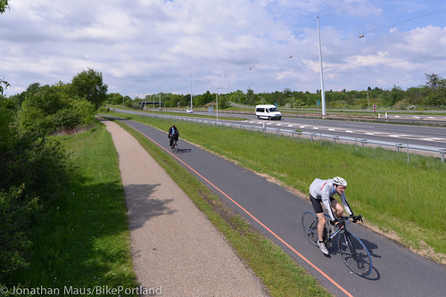
The Green Cycle Route was quite nice; but I needed to get back to the city for an appointment. Lucky for me I happened to be near the new “Cycle Super Highway”. This is a new program for the City of Copenhagen. The first one opened in April 2012 and the one I tried opened just a few months ago. The idea with the super highways is to increase the number of long distance commuters. Currently, only 20% of people who commute from more than three miles away go by bike. They want to raise that number to over 30%. “We want to spoil bike commuters,” reads a City of Copenhagen brochure about the program, “We want people to perceive the routes as a serious alternative to a bus, car, or train.”
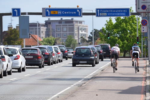
The section I rode on was adjacent to a major motorway and it definitely felt like a cycling highway:
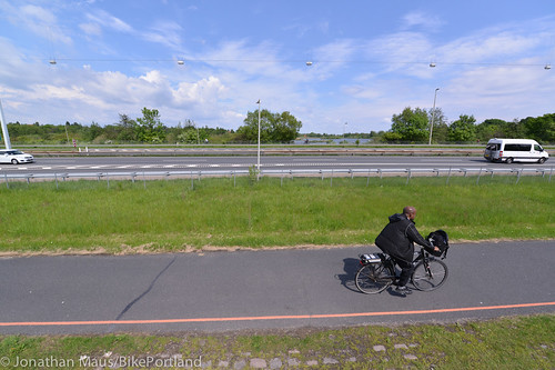
I also think there’s something very symbolic about having a quality bike path right next to a motorway. It says that bicycling is on equal footing with driving:
Eventually, the cycle super highway joined with the motorway:
As you can see in the photos, the cycle super highway isn’t really on par with a motor vehicle highway; but it’s a start. This is a new concept that is just gaining steam in Denmark and in other EU nations.
Taken together, these three types of bikeways show Copenhagen’s commitment to making bicycling comfortable, efficient, and safe no matter what type of trip you need to take.


The MUP along Hwy 26 is invaluable, and funnels a lot of riders from the north & south onto it who would otherwise have a much tougher time travelling east-west. It’s one of the few no-brainer sections of my commute, which is otherwise full of twists & turns through the side streets in an effort to stay away from roads like Cornell, Barnes, & Burnside on the west.
Ideally, there could be a lot more of these, especially in the outer areas where the space is more plentiful and the connections are really bad. Looking north of the Hwy 26 MUP, there are no alternatives for the average rider biking in & out of the city. I don’t count Cornell, Burnside or anything through Forest Park.
It would be very helpful if the path continued east of the zoo all the way down to the hill. The winding route thru the zoo is okay on the way up, but there are a few very steep sections, and on weekends there can be too much car traffic. A separated path along Hwy 26 would be an okay way to get up the hill, and a perfect way to go down-hill.
I found out a couple of years ago that it was legal to ride on the shoulder of the Sunset and have been doing it most days since. I take the MUP to to Zoo exit and then go down the hill and take the Jeld-Wen through the tunnel.
At rush hour, the traffic is usually at a near stand still waiting to go through the Vista Ridge tunnel so I tend to be the one zipping by the cars for a change. And, honestly, I find it a bit safer as going through the park there are motorist that are looking for a parking space and nothing else, little kids that dart across the street between parked cars, and a lot less blind corners before the park.
Perhaps a little more sweeping of the shoulder would be nice. And, there have been the occasions that I have come across an accident and have had to slow and go carefully around the traffic (what other street would I not have to do that anyway?) But, overall I have found this cuts a good 10 minutes off my commute.
Great pictures and write-up. The I-205 and similar bike paths here seem to fit the bill for cycling superhighway, although several of the crossings definitely need to be improved to be comparable. And the more clearly marked separation with peds would be nice – for the benefit of people walking and biking.
One of the defining characteristics of a Cycle Track is the separation from pedestrian areas. It would be great to see that kind of separation integrated into our current trails.
Where I used to live one of the bike paths had a separated pedestrian path which went almost completely unused, except by me when I would hop over to it to avoid joggers and dog walkers.
I want to point out that what is often called a “cycle track” in Copenhagen does not in any way resemble a cycle track in North America. I believe that if PBOT built the kind of facility pictured in the 60 km zone above many “copenhagenistas” in Portland would be quite upset about the lack of separation.
A small lip of pavement does not offer the kind of protection that most advocates of cycle tracks in the USA desire. Moreover, in many cases in CPH this small lip is quite small (or even ramped). Lets be honest, one of the reasons that cycle tracks work better in Copenhagen is because they resemble 2-3 m bike lanes. Because they have unobstructed sight lines like bike lanes, they are safer at intersections. In fact, I would argue that when it comes to separation and safety there is little difference between the typical copenhagen cycle track and a Munich-style buffered bike lane. Since complete physical separation is both expensive and relatively rare in Copenhagen why not just follow Munich’s lead and build more buffered bike lanes?
I also notice a lack of driveways in most CPH pictures of cycle tracks – not something many places in the US control well.
Main article:
I also think there’s something very symbolic about having a quality bike path right next to a motorway. It says that bicycling is on equal footing with driving
I think this would be the chief advantage of a Sullivan’s Gulch MUP: while it wouldn’t be a scenic ride more often than not during rush hour cyclists would utterly smoke the inbound I-84 parking lot. If enough people see that they might consider not sitting traffic.
Federal rules require a shoulder for diabled vehicles on major roadways, it’s a safety thing. I don’t see them in the pictures, so this tells me the cycle track is the auto break down lane.
How is a breakdown lane on I-84 relevant to the the Sullivan Gulch MUP in any way other than that they would be parallel? They would be separated by 3 separate rail lines.
The Sullivans Gulch MUP doesn’t involve I-84 at all, besides running next to it..
Exactly.
But still painfully visible to drivers moving 0mph on I-84.
More practical in Portland would be Bike Rapid Transit. Think light rail road conversion for bikes instead of trains or buses. Do the road diet, but combine everything in the middle for cyclists. Minor roads become right-in right-out only. Major intersections have protected left turns, so through cyclists go with through auto traffic. Left turning cyclists use the left turn pocket. Right turning cyclists use a wider crosswalk. Another benefit is the new median doubles as a refuge crossing for pedestrians at all the minor side streets.
As long as there is no separation between bike lanes (e.g. as for Moody) I could get on board with this.
Great photos! I particularly liked the bike route around the construction zone. Here, they’d just block it and leave us to our own devices. I think a vacation Copanhagen just might be in order!
I love that their ‘protected bikeway’ in the construction zone is much more protected than 99% of the facilities we have in Portland. And by ‘love’, I actually mean that I am jealous.
All left hand turns by cyclists in Copenhagen (at major intersections) are accomplished by “soft lefts”. If you want to go left at an intersection, you cross the intersection using the right side cycle lane and then loop into the right side cycle path of the perpendicular street and wait for the light to change. It’s slower, but it’s far more relaxing and it keeps the cyklister out of the auto lanes.
Agreed, if the bike lane is to the right of through traffic.
These kind of multi-stage lefts are practical in Holland and Denmark because trips are short and average speeds are achingly slow. Try this in PDX and you will just see what happens on eastward Hawthorne every evening commute (e.g. multiple cyclists merging across three lanes).
With the City Club proposing more Cycletracks here in Portland, I think there needs to be a good deal of discussion about design. Jonathan linked to an article recently where the author was steadfastly against cycle tracks and I have to agree with most of his points. Removing bikes from the sightlines of normal traffic, where driveway and right turns have to cross the track – is more of a safety hazard than it solves. Plus the right of way costs within the city to add space for cycle tracks is extremely expensive. I like the idea mentioned above for center way tracks – that might work better in many situations in Portland than bike lanes or side tracks. What we need are a portfolio of design standards that work for the many modes that designers can apply on a site by site basis. Frankly – I hate making copenhagen lefts – I want to make a left like any other vehicle… but I’ve been biking for over 20years and am comfortable in traffic.
You should read Heine’s follow up where he proposed solutions using Munich as a model:
http://janheine.wordpress.com/2013/05/28/bike-to-work-4-best-of-all-worlds-together/
I particularly enjoyed this comment where he contrasts “Greenways” to Munich-style bike boulevards:
“Neighborhood Greenways” appear to be a watering down of the concept of bicycle thoroughfares where cars are tolerated, and where bicycles have the right-of-way over cross-streets.They seem to amount to little more than just a few signs posted inconspicuously to avoid annoying anybody. We need to demand better than that.
Coming over for a visit in Malmö?
Sorry Marcus. Looks like I’m running out of time this trip. I need another week!
Thanks for the great photos, Jonathan. As someone who gets around primarily on foot now, I’d like to see more hard+soft surface trail systems (photos 9-12) in the Portland Metro region.
This “Regional trail accomplishments” (April, 2013) report from Metro helps me envision the possibilities:
http://library.oregonmetro.gov/files/trails_accomplishments_report_2013.pdf