
a more frequent sight in East Portland.
(Photo © J. Maus)
As we shared on Wednesday, the Portland Bureau of Transportation is ready to roll on a set of projects that are likely to give a major jolt to the anemic active transportation network in East Portland.
The draft East Portland in Motion implementation strategy an impressive body of work that combines PBOT’s strengths in bikeway engineering, a collaborative planning approach, and their commitment to fund projects that aren’t car-centric. It’s also noteworthy for the level of knowledge and engagement brought to the table by citizen groups like the East Portland Action Plan bike subcommittee (a.k.a. EPAPBike).
In this post, I’ll share more details on the bikeway projects in the EPIM strategy that you can expect to see on the ground starting now (depending on the weather) through 2012. (*I’ll focus only on bike projects, but it’s worth noting that this strategy also calls for a lot of new sidewalks and other improvements.)
The recommended, bike-specific projects in the EPIM draft report include:
- 10 neighborhood greenway (a.k.a. bike boulevard) projects for a total of 29.5 new miles of bikeways.
- Five “separated in‐roadway” (bike lanes or cycle tracks) bikeway projects totaling 7.2 miles.
- Three bike parking projects which could provide as many as 476 bike parking spaces
- Five shared-use path (a.k.a. trail) projects that would total three miles of carfree bikeways (these projects would be managed by agencies other than PBOT, and the EPIM merely “pledges city cooperation” on them).
Below is a closer look at some of the projects listed above that are set for implementation between now and 2012 (info taken directly from EPIM draft report):
Neighborhood Greenways
130s Neighborhood Greenway
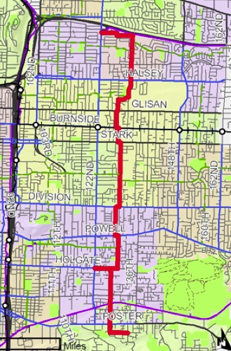
Description: North‐south neighborhood greenway spine along NE 132nd Ave, NE 128th Ave, SE 129th Ave, SE 130th Ave and SE 128th Ave from Interstate 84 to SE Foster Road through the heart of East Portland and the David Douglas School District. Route uses primarily local service streets, except one mile along SE 130th Avenue and one mile along NE 132nd Avenue, both neighborhood collectors. Six crossing improvements (potentially including two‐way cycle tracks) needed at selected arterials: Glisan, Burnside, Stark, Division, Powell.
Benefits: Provides low‐stress alternative to 122nd Avenue, connects to MAX Blue Line, eight bus lines, Springwater Corridor and several schools including David Douglas High School. Improves pedestrian safety at crossings of Glisan, Stark, Division and Powell.
Length: 6.49 miles Cost estimate: $1,345,000 (low‐confidence planning‐level estimate)
Funding and partnerships: Three‐phase implementation over next 3 years, beginning with portion south of SE Division St. Part of East Portland Active Transportation to Transit grant application to Metro Regional Flexible Funds 2013‐2014. Earlier work funded through PBOT Affordable Transportation fund.
—
“4M” Neighborhood Greenway (Market/Mill/Millmain/Main)
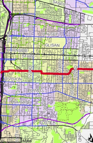
Description: East‐west greenway along SE Market Street, SE Mill Street, SE Millmain Drive and SE Main Street, from the I‐205 Multi‐Use Path to the border with Gresham. Route is classified as a neighborhood collector and a major emergency response route, necessitating different traffic calming devices than are used on local service streets.
Benefits: Serves as a primary east‐west greenway spine through the heart of East Portland, with lower stress conditions than Division or Stark streets. Provides access to SE Main Street MAX station, Adventist Hospital, Parklane Park, 4 David Douglas schools, 3 Centennial schools and 2 private schools. Continues existing Harrison/Lincoln greenway, creating a low‐stress route from Gresham to the Willamette River.
Length: 4.37 miles Cost estimate: $350,000 (low‐confidence planning‐level estimate)
Funding and partnerships: PBOT Affordable Transportation fund. Opportunity to partner with City of Gresham in branding and wayfinding once Gresham’s MAX Trail is complete, creating a low‐stress bikeway between downtown Portland and downtown Gresham.
—
80s Neighborhood Greenway: Southern Section
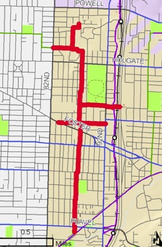
Description: Southward extension of north‐south greenway from Interstate 84 through Montavilla and Lents to the Springwater Corridor. Route uses local service streets. Northernmost portion utilizes Eastport Plaza property. East‐west connections along SE Ellis Street and SE Steele Street.
Benefits: Provides low‐stress biking and walking alternative to 82nd and 92nd Avenues. Provides access to five bus lines, Lents Park, and major shopping areas including Eastport Plaza and FuBonn. Helps spur revitalization of Lents Town Center. Serves diverse, low‐income population.
Length: 2.90 miles
Cost estimate: $600,000 (low‐confidence planning‐level estimate)
Funding and partnerships: Funded primarily through PBOT Affordable Transportation fund. Potential partnership with PDC through Lents Town Center URA. Implementation partnership with Eastport Plaza
—
Parkrose Neighborhood Greenway

Description: On‐street and off‐street connection from proposed Gateway Green park and I‐205 Multi‐Use Path to Parkrose neighborhood via NE Fremont St, NE Fremont Ct and NE 115th Ave. Neighborhood greenway treatments along NE 112 Ave, NE Fremont Ct and NE 115th Ave. Multi‐use path and bridge from I‐205 Path to NE Fremont St accounted under project T‐3; sidepath along south side of NE Fremont St accounted under project S‐17.
Benefits: Provides lower‐stress access to Gateway Green and the I‐205 Multi‐Use Path for residents of Parkrose and Argay. Beautifies and increases safety in area of overgrown vegetation along NE Fremont Street, and fills sidewalk gap here. Connects to Parkrose High School and Middle School, and businesses along NE Sandy Blvd.
Length: 1.65 miles
Cost estimate: $420,000 (low‐confidence planning‐level estimate)
Funding and partnerships: On‐street portions funded through PBOT Affordable Transportation fund.
Separated In-Roadway projects
Bicycle Safety Improvements at Intersections
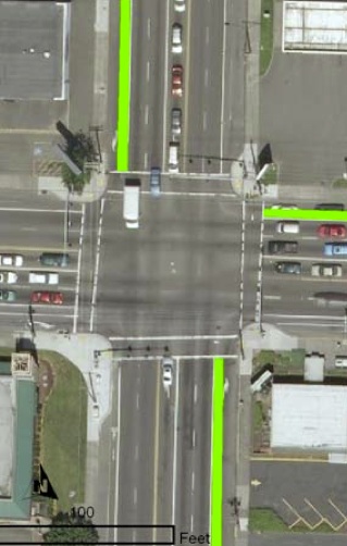
Description: Bicycle safety improvements at intersections where bike lanes discontinue at right turn lanes. Preferred treatment is extending green thermoplastic bike lane up to the crosswalk. Alternative treatment is installing bicycle sharrow markings within shared right turn lane, along with “begin right turn lane yield to bikes” sign. Locations include intersections along 122nd Ave, Division St and Halsey St.
Benefits: Provides additional safety for bicyclists at intersections. Indicates where bicyclists should be positioned in the turn lane. Lets motorists know to expect bicyclists at intersections.
Quantity: Approximately 20 intersections
Cost estimate: $20,000 (low‐confidence planning‐level estimate)
Funding and partnerships: PBOT Affordable Transportation fund
Timeline: Construction to start as soon as possible.
—
NE Glisan Bike Lane Pilot Project: 148th – 162nd
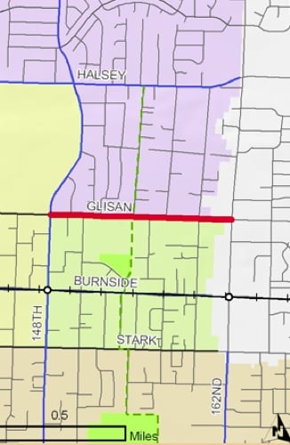
Description: Bike lanes on NE Glisan St from NE 148th Ave to city limit near NE 162nd Ave. Requires parking removal on both sides of street. Available space (approximately 7 feet on each side of the street) allows for modest buffer between travel lane and bike lane.
Benefits: Extends existing bike lanes on Gresham’s portion of Glisan Street westward into Portland, connecting to proposed 150s Neighborhood Greenway and existing bike lanes on NE 148th Ave/Dr. Improves bicycle access to Glenfair Elementary School and Glenfair Park. Serves as pilot project for streets with cross sections that prevent co‐existence of parking and bike lanes (Stark is another example). Serves Glenfair neighborhood, which has highest active transportation demand score in East Portland.
Length: 0.69 mile
Cost estimate: $20,000 (low‐confidence planning‐level estimate)
Funding and partnerships: PBOT Affordable Transportation fund. Project is supported by Glenfair Neighborhood Association and Reynolds School District, both of whom will be key partners during community outreach and implementation.
Bicycle Parking Projects
East Portland Bike & Shop Pilot Project
Description: Pilot project to install secure, high‐quality bicycle parking at suburban format shopping centers, small retail pods and employment centers in East Portland. Design will vary by location, but will aim to comply with city zoning code, which requires bike parking within 50 feet of the main entrance of the primary building, or distributed when multiple primary buildings are present. Safe passage between bike parking and local bikeways will also be considered. Timeframe is 2011-2013.
Benefits: Provides bike parking at shopping centers that were built prior to city bike parking code. Encourages bike trips for retail shopping while reducing automobile trips. Increases visibility of bicycling as an option for shopping. Addresses geographic inequity of city‐provided bike parking.
Quantity: Initially 8‐12 locations with 2‐8 spaces at each.
Cost estimate: $15,000 (low‐confidence planning‐level estimate)
Funding and partnerships: A combination of funds from GTR, EECBG and the PBOT bicycle parking fund, supplemented. Partnership with EPAP bike subcommittee to identify and engage willing owners/managers of shopping centers. Expenditure of public funds on private property requires legal/policy clarification.
—
On-Street Bicycle Parking for Traditional Business Districts

Description: Bicycle parking within the street right‐of‐way, either in the sidewalk furnishing zone or in the parking lane as “bike corrals.” This type of bike parking is most appropriate in traditional business districts where building entrances are close to the street edge. Potential locations in East Portland include:
- Parkrose (NE Sandy Blvd: 105th – 109th)
- Gateway (NE Halsey/Weidler: 102nd – 112th)
- Eastern Montavilla (SE Stark/Washington: 82nd – 92nd)
- Lents (SE 92nd Ave: Reedway ‐ Woodstock).
Benefits: Addresses geographic inequity of city‐provided bike parking. Helps increase bike usage for trips to local businesses, and can boost local business patronage in general. On‐street bike parking, including bike corrals, have been extremely successful in many Portland business districts.
Quantity: 80 staple racks (20 in each business district)
Cost estimate: $5,000 (low‐confidence planning‐level estimate)
Funding and partnerships: Funding through PBOT bicycle parking fund. Buy‐in from local business associations and business owners is key. Bike parking on NE Sandy Blvd will require partnership with ODOT, unless side streets are used.
I think this is a pretty big deal. If you do too and would like to know more about it, you can download the draft report from PBOT’s website.


I wonder if we could get the City of Maywood Park on board to complete the Parkrose Greenway one block west to the I 205 Corridor on a straight shot. I have my doubts on it being possible given that MP seems to be hostile to even having the I 205 Corridor going through their town.
I see reason for Maywood Park to change a thing. Keep it as it is.
We’re talking about navigation signage that just goes through Maywood Park, instead of treating it as a black hole by going around it to the south.
Have questions? Want to hear more?
Come to the Bicycle Brown Bag on Thursday, Oct. 20th – Ellen Vanderslice and Steve Szigethy will give a presentation on the East Portland in Motion strategy for active transportation. Noon, at City Hall. And bring your lunch! (Click my name for more details.)
80’s greenway: it’s good to see an improvement/alternative to the I-205 path…
I’m not sure it’s meant to be an improvement or alternative to the I 205 Corridor, but rather a local arterial for an underserved part of the lower eastside.
What constitutes “east Portland”, does the 50’s bikeway not count?
For the purposes of the E Ptld in Motion strategy, it’s all of the City east of 82nd Ave.
A lot of people consider the lower eastside (everything west of Veteran’s Freeway, north of the Milwaukie Expressway) broadly as ‘central’ Portland.
RE: Green paint in the right turn-lanes.
So bicycles are going to block the right-turn lanes when present? That may invite conflict, but it’s better than merging into arterial speed traffic.
It’s not uncommon for combined bike & right turn lanes, especially in Washington County. TV Highway westbound practically invented the phrase “right turn only except bicycles.” It doesn’t invite anywhere near as much conflict as expecting right turning traffic to cross the bicycle lane, which is typical at driveway locations.
Wow, it’s about time we got something out here. I commute to the airport via 122nd St. and risk my life everyday. When is the estimated completion date for all of these projects?
I think it plans for a 5 year implementation.
I’m greatly impressed by this effort and plan to attend the brown bag. I’ve also asked that the Planning and Sustainability Commission be briefed on this as an example of planning infrastructure to address equity issues. That will happen on October 25th.
Man, as an E-po resident (did I just coin a term?) I love seeing this stuff. Love it. I bike commute from Montavilla (more racks – yes!) to downtown Gresham daily, and it’s steadily improving. When the 4-M project and Gresham’s lightrail trail is done, that’s practically door-to-door for me. I didn’t see mention of the 80’s greenway NORTHERN section. I follow the sharrows, and see the paint for work on Stark/Washington. Is that fully funded? What’s the completion date?
I hope not. Based on the high rating of a recent post on Google+, calling stuff “e-po, nopo, nolo, or the couve” is generally considered annoying to long-term/native residents of Portland. I mean, if you want the bay area/new york city, you know where to find it.
Awesome! I’m particularly excited about the 82nd ave alternative.