

the entire region.
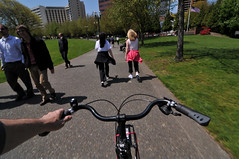
(Photo © J. Maus)
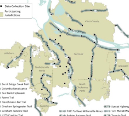
Metro has released its “2011 Trail Use Snapshot” report. The report (PDF here) is an analysis of local trail usage data complied by the National Bicycle and Pedestrian Documentation Project from 2008 to 2010.
Among the 25 multi-use paths (I prefer that term to trails) that were part of the analysis, several of them are key transportation routes for bicycling in and around Portland. In fact, the survey data (gleaned from 3,012 completed forms) makes a compelling case that paths like the Eastbank Esplanade, the Springwater on the Willamette, and the Waterfront Path are crucial bicycle transportation corridors.
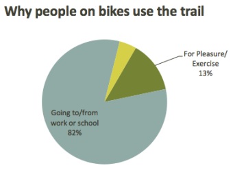
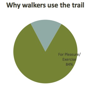
While mode share on “the Intertwine” (a network of paths and natural areas and the name of an organization that works on them) is almost evenly split between bicycling (48%) and walking (50%), the two modes use the trails for completely different reasons. The graph below (from the report) shows the difference in “trip purpose”:
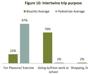
The analysis not only shows the importance of these paths as key pieces of the bicycle network; but it also might help explain why conflicts between users are so prevalent.
With most of the people bicycling on the paths using them to get to work or some other non-recreation destination; people on foot are using the trails almost exclusively for recreation. These different trip purposes naturally lead to different behaviors among users, which likely accounts for some of the tension between them.
Looking at all Intertwine users as a whole, 60 percent use the paths for recreation while 40 percent use them for transportation. “These findings support the belief that trails are transportation facilities, equal in importance to roads or highways,” writes the reports authors, “But attention must be given to their dual role as recreational amenities.”
When asked for the top factors that influenced route choice, the answer from people bicycling also reflected the transportation-oriented trip purpose:
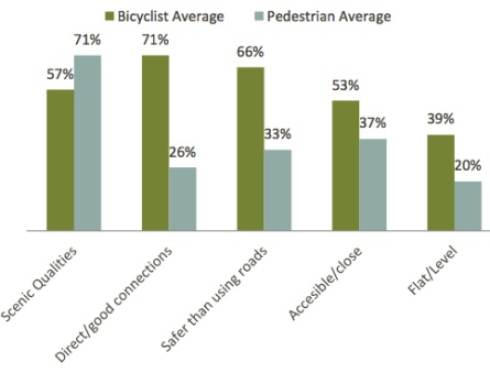
Those very high marks for “direct connection” and “safer than using roads” is just another bit of evidence that people prefer bikeways completely separated from auto traffic.
A few other key findings:
- The gender split of bicycle riders on the Intertwine is 30% female and 70% male*. (*Note: I had these number swapped mistakenly when this story was first published.)
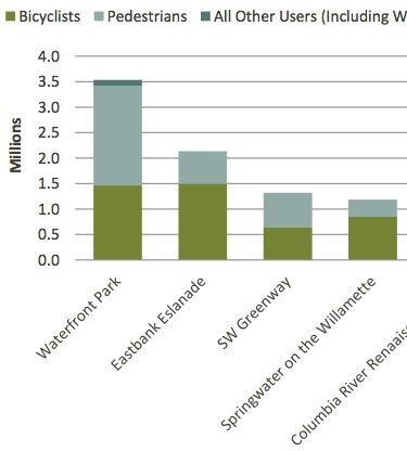
- “With an estimated 3.5 million trips per year, the Willamette River Greenway in Portland’s Tom McCall Waterfront Park is The Intertwine’s most popular trail. “
- “Trails next to freeways and busy roadways draw significantly more bicyclists than pedestrians.”
- “Longer, better connected trails tend to have a higher proportion of bicyclists.”
- “Shorter, less connected trails tend to have a higher proportion of pedestrians.”
The report also has detailed snapshots of each one of the 25 trails that make up the Intertwine. Here are the stats from the Eastbank Esplanade:

And here’s why people are bicycling on the Esplanade…
And why they’re walking..
Of the top five “Intertwine trail corridors” four of them are near downtown Portland. The chart below shows their estimated annual usage split between bicycling and walking…
These counts are extremely valuable because they give us statistical support for making good policy and more importantly, they are used in grant applications to go after funding to build more of them.
— Learn more about the counts and download a PDF of the report here.