14 days due to high water.
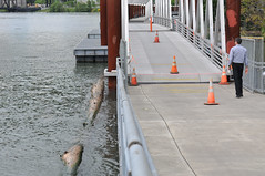
(Photo © J. Maus)
Portland Parks & Recreation officials say they continue to monitor the water levels on the Willamette River and that a re-opening of the Eastbank Esplanade could come by the end of this week.
The floating portion of the Esplanade path (south of the Steel Bridge) has been closed since May 31st when PP&R decided to close it due to the highest water level the structure has seen in its 10 year history. Last week, Parks estimated that the river would reach 16 feet — which would allow them to re-open the path — by tomorrow.
Parks spokesman Mark Ross now says a re-opening tomorrow is “doubtful” and that the earliest it will re-open is most likely Thursday.
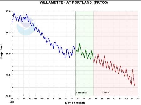
Data kept by the National Oceanic and Atmospheric Association shows that Willamette River levels are trending downward, but aren’t expected to be well under 16 feet until the end of this week.
“The engineers also say they want to give a few inches of pad around that 16-foot target level,” Ross told me via email, “so that any more rain doesn’t cause the walkway to be re-closed after it re-opens.”
We’ll keep you posted.
UPDATE: Since someone mentioned detour signage in a comment below, I thought I’d share a response from Mark Ross when I asked him about it:
“As you know, signs indicating the temporary closure are of course in place. Walkers, runners and cyclists may cross over to the west side of the river via the Morrison Bridge, the Steel Bridge, AND the Burnside Bridge, providing cyclists can carry their bikes up a long set of stairs to the top of the Burnside Bridge (and there’s a trough on the side of the stairs for bike tires to be guided up the Burnside Bridge.) They may also head east into the city; but I think what you’re asking is if there are or will be signs along city streets showing bicyclists alternate routes during this time.
The Esplanade closure was made on short notice, in response to emergency conditions, rather than a pre-planned construction project. There are not plans for bike signage detours for areas off of Parks & Recreation territory at this time. The reason is that PP&R does not have jurisdiction over the streets, or signage on them, so it would be up to the Portland Bureau of Transportation (PBOT) to address whether or not the higher than usual bike traffic on surrounding roads would merit temporary signage. We have in fact asked an engineer with PBOT about this issue; and they were open to considering a few signs ON the trail (not on the roads leading up to them) at 3 key spots, to give folks advance warning of the temporary trail closure ahead. However, depending on what our teams determine this week; the Esplanade may reopen by the time the signs are prepared; so more info on the river forecast will determine if there is a course of action in that regard.”


the Columbia has started to rise a bit again over the last couple of days
http://waterdata.usgs.gov/wa/nwis/uv/?site_no=14144700&PARAmeter_cd=00060,00065
Thank goodness for your blog, Jonathan, since it might be the only way anyone will have to know whether the Esplanade has reopened. The only notice that it is closed is a postage-stamp sized paper notice that you might, possibly, see once you’ve already arrived at either end of the closed section. Then you’ll have to turn around to cross over the Hawthorne or the Steel Bridge to get to the west side. The right thing to do, of course, would be to post large and visible detour signs before you get there at a point when you can actually do something about it. That’s certainly what they would do if closing any busy route to auto traffic. The same consideration needs to be shown toward bike commuters if bike commuting is ever to become reliable and convenient enough to attract more people than it already has. Anything you can do to convey that message, Jonathan? And, hello, BTA?
Ed
Ed, I asked Mark Ross at Parks about detour signage. Here’s his response:
Dear Mark Ross,
Walk down to Kinkos and ask for a half dozen laminated poster boards in bright colors stating the closure in large bold font so that someone passing on a bike has a chance of seeing the sign. The 8X11 white copy paper isn’t adequate. This shouldn’t require cross-agency collaboration.
Thanks,
The hundreds of bicyclists who use the esplanade to get to work every day.
“Not our problem” doesn’t seem like a very helpful response. It is a problem for people riding bikes if they encounter unexpected facility closures, and P&R should either create proper detour signs/maps or make sure that PBOT does it right away when they have to close a facility. Don’t you think the City would bother to put up detour routes if they closed MLK/Grand? This facility is of similar importance for people who travel by bike. (And I’d note that he suggests people can use the Morrison Bridge, which is of course closed.)
Jessica, it sounds like (to be fair) that the parks department is saying that it is their desire but not their jurisdiction to put signs up on the main road. They are not allowed. Nor do the have the facilities (the actual road detour signs) to exercise such desires.
Update update: The Morrison Bridge seems to be an option no longer.
I was just kind of annoyed before I read Mr. Ross’s response. Now I’m a) furious and b) a little sorry for this guy. First, thanks immensely, Jonathan, for collaring him on such short notice. And I suppose I should be a little grateful to him for responding. BUT:
*. Has he ever walked or biked himself on the esplanade? Why did he think I was asking for signs out on the street. The signs should be ON THE BIKE PATH before you reach the esplanade so that you can turn off before you get there. A good spot would be just before the Hawthorne Bridge for north bound riders, and just before the Steel Bridge and at the ramp entering the bike path for south bound folks. Like, duh, so you don’t get all the way to the closed esplande before you have to turn around to detour.
And they could do daily annoucements, with useful advice and suggestions for detours.
*. How helpful is the spokesman who doesn’t even know the Morrison Bridge is closed and proceeds to suggest taking the Morrison Bridge? Yeah, they thought about this really hard. Jonathan, you printed a quote from someone early on, as they were first considering the closure, who promised–I’m paraphrasing–expert signage and help w/ detours. And we got ….
*. Does parks and rec not have a phone# to reach PBOT? One might have enough imagination to think, “Hey, we’re going to close one of the major transportation routes in Portland, Oregon. Do you think we should give the folks responsible for transportation in Portland, Oegon to coordinate this?”
–Or not.
*. Yes, they did have to do this on short notice, but they’ve had over a week since. And, I think that if the Marquam Bridge collapsed, someone could get visible, readable, and helpful signs up and word to the press before too many autos drove off the freeway into the river for days afterward.
*. How about a sign–and we’re still talking about signs on the bike path–that gives suggestions for detours? No, they don’t have to paint little arrows all over the street. Most of us figured it out, eventually, but, again, this is a courtesy that would be done for motorists, or there’d be hell to pay. Maybe these guys need to get a little hell for their discourtesy.
+1
Remember that PP&R is a city agency, and the bridges are under county jurisdiction. City employees aren’t always aware of what is happening with the county’s bridges. Which really says that the county needs to be better at communicating closures to city agencies, and the city agencies need to be better at disseminating that info to their staff.
Not saying you’re wrong, Ed – just saying that the problem isn’t that simple, and blame isn’t easily and conveniently assigned.
The esplanade along with all the other “linear parks” should be moved to PBOT jurisdiction, and then they should change their name back to PDOT. These “parks” are used more for transportation than recreation at this point and the city should formally recognize that.
On the day of the closing I sent a message to PP&R, PBOT and PPD mentioning that it might be a good idea to include some signage indicating the closure of the Esplanade, not just so cyclists could see it from surface streets but so that auto drivers would be warned of confused bicycle traffic on roads in places where cyclists normally would never go.
Alas, I do not have the rep of JM.
Speaking of signage, it did look like a fancy sign with blinking lights was going up yesterday morning at the intersection of NE Lloyd and the off ramp from the Steel Bridge to indicate when the lower deck was raised. Not sure exactly how they will time it, but seemed like a cool idea if you need to keep moving (I personally love staring at whatever is going by, but not when I’m late!). I meant to check it out this morning, but I walked right by…
Echoing a couple of comments above, it is NOT true that “Walkers, runners and cyclists may cross over to the west side of the river via the Morrison Bridge, the Steel Bridge, AND the Burnside Bridge”.