

a major commute thoroughfare
and recreational facility.
(Photo © J. Maus)
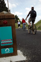
The Springwater Corridor Trail is the closest thing Portland has to a bicycle superhighway.
When the trail is complete, you will be able to walk, run, skate, or ride your bike from the Steel Bridge all the way out beyond Gresham without ever sharing the road with a motorized vehicle. For now, only two major gaps remain, both in inner Portland, where you must exit the trail and wind through city streets.
The southern gap routes you through quiet, residential streets in Sellwood from SE Umatilla close to the river to SE 19th. The northern gap, from the current trailhead at SE Ivon to the beginning of the Eastbank Esplanade at OMSI, is by far the worst of the two, crossing through a major construction zone and the entrance to a gravel depot, creating a safety hazard and a signage and enforcement conundrum.
So what is the current status of these gaps?
The northern gap crosses several properties. Development permits for these properties are contingent on the owners providing right of way for the trail; prospects for each vary.
In the graphic below, a red dotted line shows an approximation of the City’s preferred trail alignment:

It’s been over a year since we reported that land owner SK Northwest gave up its protracted battle over including the trail in their redevelopment. The capitulation was a victory for trail supporters and the City, but no action has been taken since.
PBOT’s Kurt Krueger told us on the phone this week that SK Northwest is “in the door with the building permit” and on the verge of redeveloping the property, including the trail segment and an extension out to Division Place. Krueger suspects that development will begin in spring or summer of 2010.

share the road with gravel trucks andconstruction.
(Photo © J. Maus)
But that trail segment will only be a dead end until right of way through private property to the north and south can be secured. The property immediately to the south is slated for redevelopment, Krueger said, including its segment of the trail, but the project has been delayed for over a year now, because of the economic slowdown and other permit issues.
“They don’t want to provide that trail.”
The property to the north of SK Northwest is owned by the Portland Spirit, and poses the greatest difficulty. “They don’t want to provide that trail,” Krueger said. “They have been extremely resistant almost to the point of threatening. Until they sell, or come in and redevelop, I don’t see any way we can get that trail unless the city comes in and condemns the property.”
The task of condemning part of the property would fall to the Parks Department, Krueger said, but due to funding shortages he doubts that such action will be a priority anytime soon.
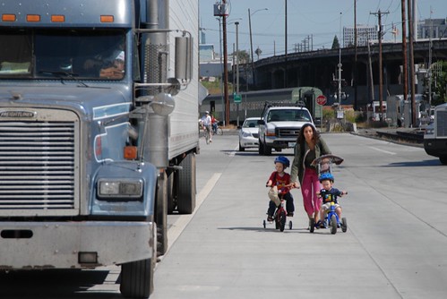
northern detour forces this family into the road.
(Photo © J. Maus)
The southernmost of the four properties is owned by Ross Island Sand and Gravel, who have no foreseeable plans to move or redevelop their lot, Krueger said. “So what we’d have in my best guess is you’d come down the Springwater running north and you’d still have that one little interaction where the sand and gravel trucks are coming out at SE Ivon.”
By comparison, the southern gap (see below) has a gentler history and kinder prospects. It requires users to make a detour through quiet, pleasant residential streets in Sellwood.

Mark Lear and Kyle Chisek, PBOT staff who are overseeing the detour, say that some of the funding needed to complete this part of the trail exists, and that Metro is negotiating with the land owner, Dick Samuels, over purchasing more sections of the right of way.

a former gap in the Springwater.
(Photo © J. Maus)
Mr. Samuels most recently sold Metro the land for the Three Bridges connection of the Springwater out to SE 45th; and he also owned some of the northern right of way that has already been bought and built. “He’s a great partner,” Chisek said, “and while we can look at getting more right of way in the future, the line still has some use and he’s still considering his options with it.”
“Metro is fairly sure they can narrow the gap further, possibly all the way to Linn Street,” Chisek said. “It’s up to the rail line owner. Metro is not going to condemn, they want to negotiate with a willing seller.”
But, Lear and Chisek said, they have a greater hope than completing the trail which is to fill in the southern gap with a combination of new trail and bike boulevards.
Part of the current detour already takes you along the new Spokane Street bike boulevard, which had its grand opening on Saturday. (The southern trailhead of the northern section is currently at Spokane rather than Umatilla due to sewer line construction that runs through February.)
Chisek says that there are several options for making the connection. The neighborhood, he says, wants the trail to go across Umatilla and down 19th Ave, “but that could change.”

on Spokane Street.
(Photo © Adams Carroll)
Another option being weighed by the Parks Department and Metro is to purchase the land to expand the trail south five more blocks to the quieter SE Linn, and give that street the full bike boulevard treatment.
Both of these options, Chisek said, would allow for “creating Bike Boulevard improvements similar to what we’re doing on Spokane but a little more advanced. If we have the funding for it we’ll be able to a little more, like a signalized crossing improvement at 13th. If we’re doing Linn, SE 17th will need some kind of signal work. Or if we want to connect [the boulevard] with Spokane, we’ll have to look at something at Tacoma and 19th.
These options will be discussed at the Sellwood Moreland Improvement League (SMILE) general meeting on January 6th; both Chisek and Lear plan to attend.
Federal funding to “fill the gap” has been allocated, Chisek said. “We hope to begin design as soon as we have an agreement with ODOT and Metro in 2010. Depending on the design and the work needed, we may also begin construction next year.”
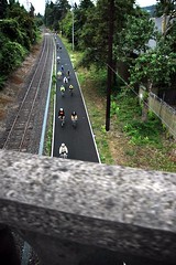
a working railroad track.
(Photo © J. Maus)
“This is really a unique project and opportunity to show case how our boulevard system is on par with — and even have advantages over — a traditional trail network,” Lear said.
A former rail line, the Springwater connects central Portland south to Sellwood, then east through the Johnson Creek area and east Portland to Gresham. It continues unpaved all the way to Boring. The train line’s heyday a hundred years ago saw the development of multiple towns and neighborhoods where trains stopped to pick up and drop off passengers and produce.
Planning for the current multi-use path began in the early 1990s. The section connecting the two gaps between SE Umatilla and SE Ivon was built in 2005. In a new era of bicycle oriented development, it may come to serve a similar role as it did as a rail corridor of building communities and strengthening connectivity between them.
– We’ve been covering the SK Northwest saga since April, 2006 — check out our full coverage. Also browse our Springwater Corridor Trail tag for more stories.
– Other trails being advocated for — that are likely to run into similar, if not stranger challenges — include the North Portland Greenway that would run north along the Willamette from the Steel Bridge to St Johns, and the Sullivan’s Gulch Trail that would run alongside I-84.