

(See more below)
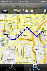
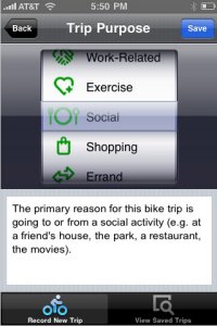
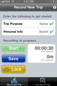
This morning I learned about a new iPhone app called Cycle Tracks. Created by the San Francisco County Transportation Authority, the app uses GPS to record bicycle trips, display maps of rides, and most importantly, logs all the information with transportation planners for use in evaluating current and future routes.
The app looks really sharp and the best part is that it can be used in any locale. We’ve already starting getting in touch with its developers and hopefully we can make this thing work in Portland.
For more, here’s what the San Francisco Chronicle said about it this morning:
“Once bike riders install the app, they tap the “start recording” button, which begins tracking their trips and displaying them on a city map. When they’re done pedaling, they hit the “save” button, and the details of their journeys are sent to the authority, as well as saved in the user’s iPhone. The app uses GPS to track riders’ routes.
The authority plans to feed the data into the state-of-the-art computer model it uses to predict future traffic patterns. The goal is to figure out where bicyclists ride, why they choose those routes and how development decisions or transportation changes might affect them, said Billy Charlton, the authority’s deputy director for technology services.”
I’ve got it installed and I’m looking forward to using on my ride home tonight. We’ll keep you posted on a Portland-specific version. PBOT currently has no mechanism for capturing real data about trip types, distance and route characteristics and this app could prove to be an important source of information.
Here are a few more screenshots:
|
|
Learn more at the app’s official website and read more detailed coverage and discussion on Streetsblog SF.