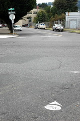
of SE Clinton and SE 11th.
This is where (I think) Ben
Ramsdell and Johnny
Eschweiler exchanged words.
(Photos by Jonathan Maus)
As a popular route for cyclists coming from the Clinton Street bikeway to the riverfront and downtown, the stretch of SE Clinton, just west of SE 11th is currently an unsafe gap in our bikeway network.
After last Friday’s road rage incident I decided to take a closer look at the current situation and what (if any) bike safety improvements might be in store for the future.
According to PDOT’s Jeff Smith, this portion of SE Clinton is not a designated bikeway on the City’s current Bicycle Master Plan (last updated in 1996). Even so, the road has been marked with bike boulevard/wayfinding dots.
While most cyclists believe these dots designate a roadway as being bike-friendly, this is not the case here. City bike coordinator Roger Geller is out of town and unavailable for comment, but in this instance I believe he placed them here to act more as way-finding aides through a dangerous area, rather than to designate it as a part of our bike boulevard network (which is how they function throughout the city).
This is a confusing situation that needs to be more carefully analyzed.
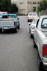
Also in the mix is that this section of SE Clinton has been reported to be a popular cut-through for motorists en-route to the Ross Island Bridge.
Bicyclists used to have a shortcut of their own to avoid this street. But recently, an off-road path along the railroad tracks northwest to SE Division Place has been barricaded and police have been doing enforcement against bicycles to shut it down.

Back to Jeff Smith at PDOT. He said that the stretch of SE Clinton where Friday’s incident took place gets about 3,600 average daily (auto) trips (ADT). Smith says that makes it a good candidate for bike lanes, “Our general rule of thumb for bike lanes starts at about 3,000 ADT”. (That 3,600 number was taken a few years ago and is likely higher today.)
According to Smith, this means there are two options for how to improve bike safety on this street:
- remove parking on one side and stripe bike lanes;
- attempt to remove/slow down auto traffic through various traffic calming and diversion measures.
removed to make room
for bike lanes.
Given the industrial nature of the businesses on the street, the parking is likely more for employees than retail customers. This would be an important factor to consider and would make parking removal less controversial for PDOT if/when it was ever proposed.
I also learned that there is an active grant in process for bike and pedestrian safety improvements near this area. Two neighborhood groups (Brooklyn and Hosford-Abernethy), along with Roger Geller from PDOT, have applied for a Community Benefit Opportunity grant (part of the Big Pipe Project).
The grant request initially included the following:
- HAWK Signals at SE 11th and 12th (recently installed on 41st and Burnside)
- Bike lanes on SE Division Place between SE 4th and 9th
- *Bike lanes on SE Milwaukie/11th/12th between Powell and Clinton
- *Enhancements to existing signage and markings (I’m not clear on which street)
(*No longer part of the grant)
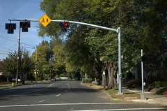
Burnside — could be coming to SE Clinton at
11th and 12th.
Debbie Caselton with the City’s Bureau of Environmental Services said that the last two requests on that list have been recently axed due to expense. Currently, the grant has made a final cut and is likely to be funded to the tune of $400,000.
There is a public review opportunity for the grant (and other finalists) on September 10th at Metro (stay tuned for details). Then, the final list of grants will be recommended to City Council in October and construction will start in November of this year.
The new, bicycle and pedestrian activated signals at 11th and 12th and the new bike lanes on SE Division Place are welcome improvements, but they don’t fix problems with the remaining safety issue on SE Clinton between 10th and 11th. If anything, they make this now infamous stretch of road an even more glaring gap in our system.
So what can we do as a community to help the City address this issue?
Two things: First, attend the CBO grant public review Open House on September 10th and tell committee members that this is an important improvement for the livability and safety of our city. Second, watch for opportunities to weigh in on the current Bicycle Master Plan update process. We need to make sure that this stretch of SE Clinton gets designated as an official bikeway. That is an important step toward giving us leverage to make necessary bike safety improvements in the future.
In the meantime, stay tuned…and ride safely.
Read more of my coverage of the SE Clinton Road Rage incident.


I choose to ride 12th over to Division and then use the sidewalk in the wrong direction to get over the RR tracks. I only use this method when family biking from my house to the esplanade so I choose this way to be safe.
Overall this area is sketchy and I try to avoid it.
The Hosford-Abernathy neighborhood has been seeking improvements here for years, as has the Bicycle Advisory Committee.
Let\’s hope that the final result isn\’t solely a bicycles-as-pedestrians solution, like the new bike lanes on SE 4th between Caruthers and Clinton.
Large sharrows markings might be a good place to start.
I have a feeling the city won\’t go for HAWK signs…that area is terribly congested any time a train comes through…with the close proximity of the tracks, that mess of an intersection, and the heavy traffic on both 11th and 12th, the signs would probably just make things worse between drivers and cyclists trying to ride through…and potentially more dangerous for collisions between cars and trains (I could see some drivers getting stuck on the tracks waiting for the HAWK signal to turn).
I live nearby, have to live with rail traffic near there on an almost daily basis…and am at a loss as to how to improve safety through that area.
Well, the City (PDOT) is the entity that applied for the CBO grant for the HAWK signals, and I\’m sure that it had to go through official channels. So, I\’d say that the City does support HAWK signals there.
I\’ve never had a problem there, I just assumed I could take over most of the right hand lane and ride with traffic. I feel the bike dots allow me… and maybe make cars aware… that it\’s o.k. for me to ride there. Atleast nobody has run me over for doing that…yet- anyway!
Vigilante sharrows?
Who likes HAWK signals, anyway? Not me! I frequently ride past the one on Burnside, and don\’t understand its appeal. I do not believe cyclists should be required to pull all the way over to the side and put their feet down to engage a signal. Do we ask motorists to get out of their cars and push a button?
I just wait until the way is clear, and go, just like before they put the signal in.
Which of course doesn\’t help Clinton, but neither would HAWKs.
\”Vigilante sharrows?\”
Make a stencil, get some surveyor\’s paint, pick a dry night and take a few trustworthy peeps with you to help…
A great way to \”protect\” your stencil is to cut out the bottom of a pizza box and tape your stencil into the space you cut out. And yeah surveyor\’s paint (cans that spray upside down) is a good idea too.
I personally like the HAWK – I changed my north-south ride to work to use it. The main benefit is that it allowed me to get across Burnside with some help during the two daily rushes. During quiet time I treat the intersection as a stop. I wouldn\’t knock HAWK\’s – they help. Though I wouldn\’t turn down one that has a loop in the ground to trigger it – ala the new southbound light at NE 22nd and Sandy.
Hmmm. That gives me an idea!
How about \”reverse HAWK\” signalling?
It would work like this: at especially dangerous intersections, the HAWK signal would be permanently red. When a motorist wanted to pass through, they would have to pull up to a control point with a button they would have to push, to get the signal to change to green for them.
Ha!
Yeah, or a ground loop that has to be driven over back and forth several times in order to activate a green light about 45 seconds later.
Reverse signalling…it\’s only fair, right?
I agree with the reverse signaling idea. Who decided it was only people in cars whose time was important? How come signals are timed for cars but not bikes? How about some streets with 20 mph timed lights and a 6 foot bike lane?
I think the reason for the huge amount of car traffic is that you can\’t make a left turn from Powell going east to Milwaulkie, and there isn\’t another safe (for motorists) place to turn until 21st. So they turn early, and end up choking that street with cars. I think people drive on that road not because it is convenient, but because the obvious route is forbidden.
This could be technically easy to do…if politically it was deemed important.
Yes there are streets in Denmark that are cordinated at the pace of bike travel (12 -15 mph) along major bike lane routes to aid bike commuters…it is much more efficent to keep human powered vehicles moving vs. stop and starting (and safer too – less being a sitting duck waiting at a light).
Which arterial in Portland should this be done first on?
I commute almost every day past SE CLinton and SE 11th, though I often choose nearby alternatives. There used to be an OK alternative to skirting next to the Ford building and crossing the tracks the wrong way, as Troy suggests. This was next to the tracks stretching diagonally from SE 11th Ave to SE Division Place. Unfortunately, the Union Pacific right of way has recently been blocked by a couple of jersey barriers – making riding beside them even more inconvenient. I am sure it is a long shot, but this route is the best between SE Clinton and the waterfront. I am not sure it would have done any good in this particular incident, but it would certainly be a great addition to the SE bike network. What would it take to widen the right of way and make bike travel alongside the rail line at this point convenient? It seems that this should be accomplished before the MAX route is established.