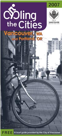
The City of Vancouver is set to unveil a new bike map (cover graphic below) at Bridge Pedal this Sunday. The map is the first to cover local bike routes for both cities since the “Cyclists Road Map of Portland District” was published way back in 1896.
According to City of Vancouver transportation planner Todd Boulanger, the first 1,000 copies will be handed out on the Fremont Bridge during Bridge Pedal and remaining copies will be available at the BTA Open House later that afternoon. After that, it will be available from the City of Vancouver and at various events around the city.
The map will be free and will include Vancouver north to about 170th Street and the Salmon Creek Greenway and then south to Portland’s southern boundary.
Boulanger says Vancouver is in a “historical mood this year” because they are celebrating their 150th anniversary as a city.
Boulanger, who regularly rides between the two cities, says the map is a, “one map resource for 90% of the bike commuters in the region.”


Look at that cover. I\’m sure Boulanger grins with glee when he sees \”…and portland, or\” under the nice big \”VANCOUVER, WA.\” Who\’s second fiddle now?!
Thanks Jonathan for the posting.
This map project has been managed by Jennifer Campos, Associate Planner, CoV Transportation, over the last 2 years, so much of the credit goes to her.
PDoT\’s Jeff Smith (and others) helped with the Portland content and GIS files. Grapheon did the layout. And members of the Vancouver Bike Club, the Clark County BAC, and bi-state advocates helped with checking the content.
—————————————–
These maps will be distributed in Portland at shops and other sites too.
So now with one map in your pocket it is even easier for Portlanders to bike up to Vancouver to enjoy our bikeways and low traffic streets…with nice smooth pavement.
ooh – now they should add the Multnomah County bike map, since it kind of weaves in and out of City of Portland.
Now if we can just come up with a decent crossing from Portland to Vancouver. My preference would be a new dedicated bridge over the Columbia for light rail and bikes only.
I wish Vancouver would put up a decent bike route sign showing the path onto the 205 South bound bike path. At least 2 times I have ended up at Fisher Landing.
The next step really is improving the connections between the two cities. How great would it be if the I205 bridge was less noisy, or less dusty, perhaps relocated under the bridge instead of between the freeways? What about after you get to the north side of the 205 why not a bike/ped bridge over to the park allowing easy access to east bound destinations like fishers landing instead of the current west then east routing. Obciously wider/better paths across the i5 bridge would also be appreciated. There is lots of work to be done on making these connections more friendly, and the increased ridership this map will lead to can do nothing but help make that happen.
bjorn
Until there is a decent crossing, I will rarely, if ever, visit Vancouver. There is currently no incentive for me to endure the discomfort of highwayland. For the foreseeable future, I will be spending my money in Portland only.
This is a great step! Congratulations Todd and team for getting this done.
I like the ride to Vancouver. The I5 bridge isn\’t great, but is short and scenic and it drops you right downtown with a nice farmers market on the weekends and events minus the insane crowds of Waterfront Park. More my speed. The Glen Jackson bridge isn\’t great either, but at 37 MPH, it\’s a quick trip home for a nice 45 mile loop (unless you get sucked westbound on Mill Plain for another 15 or 20 miles. Nice ride! Luckily I missed my turn and the road ended or I would have had to complete the circuit of Vancouver Lake.)
I tell you what though… when I was there two weeks ago, I was looking for a freaking map!
Oh yeah, and ORBA had streets roped off downtown for bike races. That was a good day. I\’ll do it again.
… next time with a map. Thank you, Todd, Jennifer and all!
I recently moved from Gresham to North Vancouver (just outside city limits), I was suprised to find that my commute time to the Pearl District was exactly the same! Granted the route is more treacherous with the I-5 bridge crossing. I\’ve been wondering if a map like this existed… Now I know, Thanks!
Hi Bryan…yep that is true…City Center Vancouver is closer to Downtown Portland [by bike, ny express bus, etc.] than many outer Portland neighborhoods…like St Johns.
City Center Vancouver…its only \’10 bike minutes\’ [over thge Interstate Bridge] to MAX.
Jonathan,
The maps are printed and delivered to Vancouver!!
I dropped off the first (small) set of the Cycling in the City bike maps over at Revolver tonight. So go over and get one from Mark. (Mark feel free to keep a couple for your staff.)
These maps will be handed out on the Fremont Bridge during Bridge Pedal and at the BTA office\’s open house.
Well the Cycling in the Cities map was a big hit at Bridge Pedal today…we ran out of them a third of the way into the ride up on the Fremont Bridge! [With the help of the PDOT Transportation Options crew handing them out too!]
[Do not worry we will be delivering maps to local bike shops and coffee shops (call us). Plus those of you who have emailed in a map request we will be mailing them out soon to you.]
Then an hour later we ran out of the remaining \’mini\’ Portland bike maps.
-Todd
Press Release:
http://www.cityofvancouver.us/News.asp?submenuID=16578&Id=43568
Get your Cycling by the Cities map now!!!
9000 maps distributed in 1 month. 1000 more to go.
…before they are all gone. No idea yet if or when there will be a print job #2.
Thanks everyone for taking the new maps to your hearts and using them to explore both of our cities. And for our Vancouver Metro [Portland] bike shops for distributing them.
Please send any comments or suggestions on the map (for reprinting) to:
Jennifer.campos@ci.vancouver.wa.us
The map is now offered digitally:
http://www.cityofvancouver.us/upload/contents/738/Vancouver_Portland_Map_Combined_Final.pdf