Recently in the forums the discussion turned to Westside commute routes. A user named “nborders” mentioned his daily commute up and over the Sylvan hill and down into Portland.
When someone asked him for more info, he posted a detailed description and even made a series of route maps using aerial photos of the area with hand-written notes and tips.
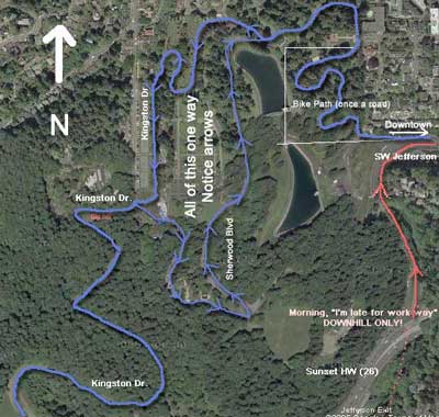
[One in a series]
Imagine what a tremendous resource it would be to have hundreds of these maps, complete with comments, recommendations and tips from riders. Online bike route planning and home made maps like these will soon be commonplace.


")

Nborders.
Would you be interested in chatting with me and combining this with my Portland Virtual Tour?
http://www.thecornucopia.org/virt-tour.htm
you can email me aaron@yourbodypower.org
I love these maps, but I would encourage people in the future (e.g., Jonathan’s dream database) to use the map template primarily, with the aerial photo as a supporting illustration. Though the aerials look cooler, all that detail and shading can become too hard to read, especially when printed out on paper to carry with you.
Who can create a hack for Google Maps that will be like Gmaps Pedometer, but will make it easier to do curved streets?
Oh, that’s cool… a few of us in Toronto are trying to figure out how to use maps to provide a kind of “BikePooling” resources to match bikers up with others in their area going the same way and maybe provide mentoring… you can see what I’m talking about in the “RideMatching” section over on CyclingCog.net (it’s a brand new site). The main aim of the site is for more than just Toronto, so feel free to register if you’re from outside Toronto.
“Who can create a hack for Google Maps that will be like Gmaps Pedometer, but will make it easier to do curved streets?”
patience grasshopper.
Well, I guess I have too much time on my hands doing 10 hour graveyard shifts, I’ve mapped out many many routes that I’ve done and potential rides I want to do on pedometer.
yeaaah.
I like the bike there map for google earth here.
Its the best, but you cant make routes, itd be nice if there were a program that had all the bike maps but you could draw in the trail you want to take. Or something that would find the best trail based on least amount of climbing and safest streets.
You could pretty much do this via wayfaring.com, more or less.