

Michael Wolfe has a seriously high bike IQ (or would that be bi-Q?). I met him at the PUMP swap meet and have kept in touch ever since. He recently introduced himself to the Shift email list and has already started sharing some of his vast biking knowledge. One of his interests is figuring out car-free ways of escaping the city.
Here are three routes he’s got so far, complete with Google map assistance from the always handy Gmap Pedometer. File them away for summer, or tackle them next weekend:
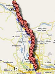
If you’re going to points north — like the Lewis River, Mt. St. Helens, or even Seattle — and you want to explore of some of the nifty country in the Gifford Pinchot National Forest in Southwest Washington or if you just want avoid riding on Highway 30 and crossing the Lewis & Clark bridge at Longview (and I don’t blame you) this is a pretty good way to go:
Portland to Longview: (See this route on Gmap Pedometer)
This route will get you from Portland to Longview, on the Washington side of the river, without once having to get on I-5. A couple things to note, though: the stretch through Vancouver is actually rather pleasant, but the stretch from Hazel Dell to north of Salmon Creek (mileposts 13 to 19) isn’t great (5 lane highway stuff) though it does have a bike lane. Getting from the intersection at 45th and Main in Vancouver over to Hazel Dell Ave is a little tricky; you basically take a bike path underpass. Also, there’s a big hill north of Woodland (mileposts 37 to 41) that is pretty brutal. You could avoid it by getting on I-5, but you’d have to stay on the freeway for 7 miles or so, and as I recall the shoulder is pretty dicey for that stretch (yikes!) You get a view of the lower Columbia River from the top of that hill that’s not like any other, too.
If you’re going on to Seattle, the path that I’ve mapped drops you off right on the StP route in Longview, which you can take north. Or use this route and jump off at La Center or Woodland to explore the Lewis River or the Mt. St. Helens area.
*****
Here’s a way to get up onto Mt. Hood without ever riding on Highway 26. I blatantly stole this route from River City’s Barlow Trail Century (a great ride with great support for a good cause, by the way!):
Portland to Zig Zag/Lolo: (See this route on Gmap Pedometer)
Again, this starts out by utilizing the Springwater Corridor, which makes it take a couple roundabout turns. If you want to substitute your own favorite method for getting out to east Multnomah county (say, Division to Oxbow, and then south to Dodge Park Boulevard) feel free. Once you get to Dodge Park, though, you don’t have a lot of options for improvising. You go through some beautiful country on this ride, including the descent to the Sandy River, the Devil’s Backbone, and Little Switzerland. Keep in mind that you are GOING UP A MOUNTAIN. There is some climbing involved in this ride. Once you get to the end of the route that I’ve marked, you can go up Lolo Pass road and camp at either McNeil (not so nice) or Lost Creek, near the Ramona Falls trailhead (beautiful). Or you can make a right turn, go down the road to Zig Zag, cross 26, and pedal a couple miles up the Salmon River and camp at Green C! anyon. This route gets you up close and personal with the mountain, and there are two good paved roads to the top of Lolo Pass, but if you want to get even closer than this takes you, you either have to pedal on gravel (Lolo Pass road beyond the pass towards Hood River, or Still Creek Road up to Trillium Lake) or get on Highway 26.
*****
Finally, here’s a route to Canby:
Portland to Canby: (See this route on Gmap Pedometer)
The key components here are the Springwater on the Willamette trail and River Road through Milwaukie. In downtown Milwaukie, you have to go through the waterfront park and pick up the bike path around the back of the water treatment plant. Otherwise, you’re forced to ride 99E to get to River Road, and that’s no good at all. Willamette Falls drive to historic West Linn isn’t a bad road to ride, though traffic can be surprisingly heavy. Turner Road is pretty and quiet, and when you get to the top of it, it’s basically a downhill roller coaster ride on Mountain Road all the way to the Canby Ferry.
Note that this route is currently inaccessible, due to the Canby Ferry being closed as the result of high water.
Once you’re in Canby, though, the world is your oyster. You could pedal over to Champoeg and take the “Land at Eden’s Gate” ride (Oregon State Bicycle Route #1) all the way down to Eugene, or just get on French Prairie road to Salem. You could get on Meridian Road and take that south to Silverton, the Oregon Garden, or Silver Falls Park. Dryland & Toliver Roads will take you to Molalla, and Dickey Prairie to the Molalla River Recreation Corridor is a nice ride. The riding down there is rural and flat, with a huge number of low traffic roads to enjoy.
And Michael adds, “I look forward to hearing other folks’ creative ways to get out of the city, and of the adventures associated with them.” Thanks Michael!