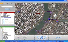
 I’ve just learned of an exciting development in Portland’s quest for an interactive bike route map. It looks as though Metro is trying to partner up with Google and their new Google Earth program. No official partnership yet, but Metro is actively experimenting with the technology (check the screenshot on the left).
The idea is to meld the popular Bike There! map with Google Earth so you can easily view and navigate the safest, most ideal bike route in a 3-D, satellite view of the city! Once this is finalized and fully functioning, you’ll be able to type in where you want to go and the program will select the most bike-friendly route automatically. Then, you can do 3-D flyover of the route before heading out.
As of last night, Metro has made it possible to play with this technology on their website. Here’s how to get started:
- Download the free Google Earth beta application onto your PC (Google says it is working on the Mac version)
- Then download this .kmz file of Metro’s Bike There! Map.
- Open Google Earth on your computer, and then from within GoogleEarth, go to file > open and open the Metro file.
- Use the dashboard in Google Earth to fly over the region and have a bird’s eye view of the bike routes.
Note: the trip planner is not yet available. Metro is still exploring the use of this technology. They would love to know what you think. Please leave your feedback in the comments.
")


3-D fly through of your bike route
Imagine entering a start and end address into your computer and seeing a street-level, bike-eye view of your cycling route.
3-D fly through of your bike route
Imagine entering a start and end address into your computer and seeing a street-level, bike-eye view of your cycling route.
cool – then all that’s left is to add various meaty figures to the simulation, and wire in the e-stores, chat channels etc. to their avatars in the map, and you won’t even need to get on your bike to go for a ride, run errands, etc. and way safer! can you say virtual critical mass? virtual naked rides? virtual naked critical zoobomb? is it porn yet? [ducks]
3-D fly through of your bike route
Imagine entering a start and end address into your computer and seeing a street-level, bike-eye view of your cycling route.
Bike trip planner via Google Earth?
Bike Portland has details of plans by Portland’s Metro transportation planning agency to integrate with Google Earth more deeply than anything else I have seen to date. Metro’s got all of Portland’s bike paths available for download as KML, but…
More fun stuff:
In Google Earth, use the Tools > Measure command to click out a path and see how long your ride was or will be.
Use the Tools > Options command, View tab, to set the Elevation Exaggeration to 3 and make sure your path takes you up and down as many hills as possible!
The bike_map.zip file is gone. Can you post it here on this site?
cool – then all that’s left is to add various meaty figures to the simulation, and wire in the e-stores, chat channels etc. to their avatars in the map, and you won’t even need to get on your bike to go for a ride, run errands, etc. and way safer! can you say virtual critical mass? virtual naked rides? virtual naked critical zoobomb? is it porn yet? [ducks]
Try again. We were trying to slip in an improved version – you probably just got there when it was being uploaded…
Try again. We were trying to slip in an improved version – you probably just got there when it was being uploaded…
The file name had been changed to “bike_there.zip”, so the link above does not work. You can get it from the Metro Bike There! page at http://www.metro-region.org/article.cfm?ArticleID=15341I’ve changed the filename in the post. –JonathanBike trip planner via Google Earth?
Bike Portland has details of plans by Portland’s Metro transportation planning agency to integrate with Google Earth more deeply than anything else I have seen to date. Metro’s got all of Portland’s bike paths available for download as KML, but…
[…] I recently posted about the City of Portland’s work on an exciting mapping project that combines our bike routes with an interactive, web-based map. I have also heard from many of you about your close calls with motorists. […]
[…] I recently posted about the City of Portland’s work on an exciting mapping project that combines our bike routes with an interactive, web-based map. I have also heard from many of you about your close calls with motorists. […]
[…] Bike Portland » Blog Archive » Bike There! map and Google Earth // […]
More fun stuff:
In Google Earth, use the Tools > Measure command to click out a path and see how long your ride was or will be.
Use the Tools > Options command, View tab, to set the Elevation Exaggeration to 3 and make sure your path takes you up and down as many hills as possible!
[…] At a transportation class I’m taking I heard from a Tri-Met bigwig that Google will be visiting with TriMet in a few weeks to discuss their ongoing collaboration on a mapping system. According to the Tri-Met rep., a detailed, fully-integrated bike trip-planning system will be available online “in about a year.” I covered this in more detail back in August. […]
[…] At a transportation class I’m taking I heard from a Tri-Met bigwig that Google will be visiting with TriMet in a few weeks to discuss their ongoing collaboration on a mapping system. According to the Tri-Met rep., a detailed, fully-integrated bike trip-planning system will be available online “in about a year.” I covered this in more detail back in August. […]
The bike_map.zip file is gone. Can you post it here on this site?
[…] The guys over at BikePortland.org are talking about how Portland Metro is teaming up with Google (using Google Earth) to create an interactive bike mapping program. […]
[…] Back in August Metro began experimenting with Google Earth. Now it seems TriMet and Google have more of an official partnership going on. […]
[…] No sign of bike-specific route planning…but then again, we’ve got a local grassroots effort well underway. And loyal readers know Google has worked with Metro on a bike-mapping project in tandem with Google Earth. Why launch this tool with Portland’s very own TriMet? Here’s what Google says: “We chose to launch with the Portland metro area for a couple of reasons. Tri-Met, Portland’s transit authority, is a technological leader in public transportation. The team at Tri-Met is a group of tremendously passionate people dedicated to serving their community. And Tri-Met has a wealth of data readily available that they were eager to share with us for this project. This combination of great people and great data made Tri-Met the ideal partner.” […]
Try again. We were trying to slip in an improved version – you probably just got there when it was being uploaded…
where is the zip file?
Brandon,
Here’s the file you need. It’s .kmz format.
The file name had been changed to “bike_there.zip”, so the link above does not work. You can get it from the Metro Bike There! page at http://www.metro-region.org/article.cfm?ArticleID=15341I’ve changed the filename in the post. –JonathanHi All Experts,
Does anyone use google earth images as ground image planes for use in aerial scenes. I know how to stitch them together but are there any tools or tricks to make sure that the images are at the same height, angle and such to make sure they stitch well. I know in the pro version you can get bigger images but im not going to pay for the pro version when i could stitch multiple images together…
Preparing my Tour de France 2007 I couldn\’t find a good map showing the Tour de France 2007 on Google Maps. So I made my own Google Map Mashup. See:
http://www.mapstars.com/tour-de-france/tour-de-france-2007-google-maps.htm
Visitors can add some links in the InfoWindow. In that case: mail me.
Rene
[…] I recently posted about the City of Portland’s work on an exciting mapping project that combines our bike routes with an interactive, web-based map. I have also heard from many of you about your close calls with motorists. […]
[…] Bike Portland » Blog Archive » Bike There! map and Google Earth // […]
[…] At a transportation class I’m taking I heard from a Tri-Met bigwig that Google will be visiting with TriMet in a few weeks to discuss their ongoing collaboration on a mapping system. According to the Tri-Met rep., a detailed, fully-integrated bike trip-planning system will be available online “in about a year.” I covered this in more detail back in August. […]
[…] The guys over at BikePortland.org are talking about how Portland Metro is teaming up with Google (using Google Earth) to create an interactive bike mapping program. […]
[…] Back in August Metro began experimenting with Google Earth. Now it seems TriMet and Google have more of an official partnership going on. […]
[…] No sign of bike-specific route planning…but then again, we’ve got a local grassroots effort well underway. And loyal readers know Google has worked with Metro on a bike-mapping project in tandem with Google Earth. Why launch this tool with Portland’s very own TriMet? Here’s what Google says: “We chose to launch with the Portland metro area for a couple of reasons. Tri-Met, Portland’s transit authority, is a technological leader in public transportation. The team at Tri-Met is a group of tremendously passionate people dedicated to serving their community. And Tri-Met has a wealth of data readily available that they were eager to share with us for this project. This combination of great people and great data made Tri-Met the ideal partner.” […]
where is the zip file?
Brandon,
Here’s the file you need. It’s .kmz format.
Hi All Experts,
Does anyone use google earth images as ground image planes for use in aerial scenes. I know how to stitch them together but are there any tools or tricks to make sure that the images are at the same height, angle and such to make sure they stitch well. I know in the pro version you can get bigger images but im not going to pay for the pro version when i could stitch multiple images together…
Preparing my Tour de France 2007 I couldn\’t find a good map showing the Tour de France 2007 on Google Maps. So I made my own Google Map Mashup. See:
http://www.mapstars.com/tour-de-france/tour-de-france-2007-google-maps.htm
Visitors can add some links in the InfoWindow. In that case: mail me.
Rene