What a week! In addition to all our regular news and feature stories we shined a light on bikeway gaps. Places where — for maddening and often inexplicable reasons — a perfectly fine bike lane vanishes for just a few short blocks.
Because if we want to fill these bikeway gaps we must first fill the knowledge gap.
Before I share your submissions and some thoughts on this topic, I want to say thanks to our business sponsors and subscribers. We need your continued financial support to keep doing this work. If you haven’t stepped up to subscribe or to become an advertising partner, please sign up (and join 200+ fellow readers!) or drop me a line today.
Now back to our programming…
The State of the Gaps
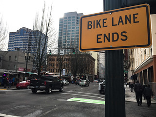
(Photo: J. Maus/BikePortland)
We learned quite a bit taking this closer look at bikeway gaps — not just about the specific locations we profiled, but about gaps in general.
As we discovered with the tragic death of Martin Greenough last month, many significant and dangerous gaps aren’t even reflected on official city and regional bike maps (in Greenough’s case, the gap he was hit in wasn’t even in ODOT’s inventory). This is a problem. These maps show continuous bikeways when in fact, on the ground, there are no bikeways. Metro is aware of this issue and has responded on one gap so far; but the City of Portland hasn’t responded to our requests for comment about it. Bike maps should reflect reality. Agencies need to be honest with road users so we can make informed — and safe — decisions.
Perhaps overlooking these gaps on maps is a byproduct of another thing we learned: Different types of riders experience gaps differently. Strong and confident riders can fly through a gap and never even know it’s a problem spot because it doesn’t impact their experience. But another person can bike through the same gap and feel their blood pressure rise. Others can be so scared of a gap they won’t even use the route at all.
Our story on a gap on SW Terwilliger had some people saying they hadn’t even noticed it. One reader, 2WheelBeamer, sent us a video showing how he was honked at in the gap mere minutes after our post went up!
Advertisement
Your Gaps
And now the moment we’ve all been waiting for: A selection of gaps as pointed out to us by you, our esteemed friends and readers. Most of them came from the excellent comment thread under our Gap Week introduction post last week. I strongly suggest all the city/county/regional agency staff bookmark or print out that page and use it for future planning reference.
We’ve also made a Google Map with our four gaps and the nine below. Feel free to add more gaps to help inform our future coverage.
From Alex Reed:
1) 87th & Flavel: Greenway ends, 1 block of unpaved road & short muddy path from the Springwater (Map)
2) Burnside gap in the Gresham-Fairview Trail is a real head-shaker.
From Amblyopia:
3) Woodstock bike lanes disappear for 1 block each direction @ SE 82nd, maps show continuous
“A long bike lane, punctuated by a short stretch of absolute terror.”
— Meghan Humphreys
From J.E.:
4) The most annoying, although not most dangerous, gap I’ve encountered is where the bike lanes drop off on SE 26th just south of Clinton to preserve a small number of parking spaces. The connection with the greenway is RIGHT THERE, but nope.
From Meghan Humphreys:
5) SE Woodstock, between SE 69th and 72nd. A long bike lane, punctuated by a short stretch of absolute terror.
From Chris I.:
6) NE 181st where it passes under I-84. The northbound bike lane on 181st ends at the freeway offramp, and cyclists are forced to cross two lanes of traffic that is turning onto the freeway onramp. The I-84 bike path also abruptly ends here, forcing cyclists who want to go north to either ride on the sidewalk, or attempt to turn left with the traffic exiting the freeway. Many drivers roll through the red light to turn south onto 181st, creating a major hazard.
From Social Engineer:
7) N Interstate around Rosa Parks. That has to be one of the most egregious in the entire city.
From Maccoinnich:
8) Ugh, NW 16th, where the bike lane disappears for 3 blocks between Johnson and Glisan to create an extra auto lane. What’s weird is that I can’t even work out why this happens. There no obvious reason why auto volumes along 16th would be higher south of Johnson than they are north of it. There is a right arrow marked for drivers turning onto Glisan, but it’s not even a dedicated turn lane.
From Ted Labbe:
9) NE 7th between Broadway and Weidler in front of FedEx Office. Bike lanes to the N and S but nothing in this 1 block section with busy traffic all around. And no good alternative route to cross the Lloyd District. This needs to be fixed ASAP.
Thanks again for all your feedback.
The big takeaway from this week is that there are simply way too many gaps in our bike network. To really do this topic justice we need to do Gap Year. On that note, we plan to keep writing about these gaps (and hopefully covering great work to close them by our friends at PBOT, Metro, the Bicycle Transportation Alliance, and so on) until there are no more left. It’s a big job, but we must create a safe and connected road system for bicycle users that is on par with what we offer people who drive, walk, and take transit.
— Jonathan Maus, (503) 706-8804 – jonathan@bikeportland.org
BikePortland can’t survive without paid subscribers. Please sign up today.


I was surprised how few gaps are on that map for inner SE, then realized it’s because the region doesn’t actually have that many true bike lanes, with most of them leading to/from bridges, and the cycling network instead relies heavily on greenways (which of course have their own “gaps,” like SE Ankeny at Sandy).
Hope it stays that way (lane free).
The map seems to be missing the NW 16th gap. I really don’t know why there is no continuous lane striped between NW Thurman and SW Salmon. Yes, the Burnside intersection is a mess and would require dealing with inattentive freeway off-ramp motorists, but it’s nothing that bike signals, paint and some new curbs can’t help.
Apologies, I should have said “between SE 72nd and SE 69th Avenues.” And, the street an eastbound cyclist could detour onto to avoid the scary spot is a one-way westbound only, so you have to break the law in order to avoid the risk.
that SE 69th/Woodstock spot is bad for everybody… it’s just too sharp of a turn… it’s signed for 20 mph, which is my MAX speed while driving, but it should probably be 15 mph…
there’s plenty of room for bike lanes, but it seems that they erred on the side of drivers swooping the corners…
I live a few blocks north of Mt Scott Park and I try to avoid the entire stretch of Woodstock between 69th and 72nd…
I was the one that reported the other Woodstock gap around 82nd…
these gaps are no fun on my way to El Nutri Taco for my vegan burrito fix…
I was riding back to work from the Lloyd Center and thought of this post. There’s the bike lane over NE 21 across I-84, and then none until you can turn off on Irving. The cars on the curve can be aggressive as you come off the bridge.
Rather than commenting here on this blog, I’ve taken a different approach to comment with 823-SAFE or safe@portlandoregon.gov for every gap that I come across. I have a feeling that PBOT would act more quickly if they received 500 requests to fill these gaps.
They seem to be slow and incompetent. I told them for months about every gap in the bike / ped network in the Lloyd district. I also called BES a bunch of times to et some storm drains fixed.
pBOT “fixed” the issues by adding a crosswalk… On the wrong side of the street. And they “fixed” a bike lane, but didn’t actually fix the root cause of the issues. bES was better since they actually fixed one of the storm drains. But they won’t deal with any of the others because they’re waiting for PBOT to “fix” the road first.
Whereas some on this blog are fast and brilliant!
823-SAFE is not best items that need maintenance, though you could go that route, the intake persons there (1.5 persons) would only refer it to maintenance at 823-1700. If it is a sign down, a stripe worn off, a ped button not working – maintenance is the direct point of contact.
823-safe is for changes to the street system that are small, think under $2k, and for police enforcement. Sign changes, signal timing adjustments, turn restrictions that might help a problem, requests for speed limit changes start there. You can call this number for things like protected bike lanes, but traffic operations does not build new infrastructure so much as adjust operations. Traffic Operations are the band aid people, not the major surgery people.
Big ticket items need to go through the capital projects funding process and planning, etc., before design and construction. These are Active Transportation and Civil Design, or Planning activities.
If your complaint is on an ODOT facility, check with ODOT first, since the specifics of the right of way govern who can do what on ODOT streets.
I’m not sure, with their 6 week backlog, whether the safe line is for reporting things the city doesn’t know about, or complaining about things they won’t fix. Which number should I call to request sweeping bike lanes after every storm? (Do they sometimes plan on doing that before anyone complains?)
I can’t believe know one listed NW Everett’s intersection with Naito Parkway to reach Waterfront Park.
I enjoyed this series very much. Thanks!
Added a few in the Cedar Mill/Cedar Hills area. The one on Cedar Hills Blvd heading into Butner is particularly nasty as it’s a steep uphill and traffic is usually very aggressive and getting ready for the horrible intersection at the EB exit/entrance of US26.
It’s probably far too late to mention this one, but I recalled a noticeable gap I thought about yesterday as I drove through the area on a route I used to ride recreationally quite frequently. NE 33rd from Marine Drive has a bike lane all the way until it curls up onto Columbia Blvd. This is potentially a very important connection, and quite dangerous where the bike lane simply disappears after rounding the southbound curve. In fact, NE 33rd has the potential to be a very useful N/S route for cycling, if the impetus to improve it south of Lombard ever existed.
I added a bunch of gaps to the map last night, and I see that other people have been adding today. Sad to think that SE Gideon is one of them, having just been rebuilt as part of PMLR.
re the missing bike lanes or gaps on N. Interstate Avenue, I have posted previously that my role in that decision has been one of my biggest regrets in the “transportation options” business.
Here is the story. When the city decided to go ahead with the northern section of the defeated “South/North” light rail ballot measure, the new MAX alignment was placed on Interstate Avenue the entire way. State law called for bike lanes, but PDC, hoping to see exciting, dense station area development called for preserving on street parking at stations where the right of way could not accommodate both. Hence, bike lanes had to go!
Commissioner Hales called for a Task Force to look at the issue, and one was formed which included the BTA Exe. Director, myself from Swan Island TMA, bike commuters from N. Portland, and folks from the business community.
After the usual back and forth, we reduced PDC’s request to three stations, Killingsworth, Rosa Parks Way (then Portland Blvd), and Kenton, dropping Lombard, Prescott, Albina/Mississippi, and Overlook Park. In order to retain parking, bike lanes would end at Willamette Blvd and resume up north at Dekum. We agreed that Denver Avenue was a suitable parallel regional North/South bike route, but insisted on improved East/West bike access to all stations, especially Killingsworth and Rosa Parks. Lanes were removed only southbound near Kenton, again to retain on street parking, with Denver as the alternate route.
So when New Seasons put in their store at Rosa Parks with a parking lot next to the MAX station, I was deeply disappointed and sorry I ever agreed to put on street parking over bike access. My apologies.
Another note, I think N. Interstate Avenue, while a great improvement over the old version, is a weird street with tons of asphalt on which one cannot walk, bike, drive, or park! Its full of asphalt “dead zones.” This is due in part to a PBOT decision to default to widest possible roadway in setting the curb with bulb-outs for trees or crossings the exception. A better design would have set the curb along the single travel lane and bike lane with cut outs for parking were desired or where it could be accommodated. Note that the Polish church chose to give up their parking in order to retain their beautiful dogwoods, but that was the exception. That should have been the rule, with bike lanes the entire length of the Avenue. It would have made for a greener, more bike friendly, truly multi-modal street, a real “avenue!”
Hello,
I actually reported the Fairview-Gresham Trail intersection with Burnside via ORCycle a few days ago. The safety issue I reported was with how there are cars parked on the part 202nd Ave that connects the Burnside bike lane with the continuation of the Trail right to the south. It isn’t clear if that little spot is a bike lane, or a parking lane, but as cars park there it pushes bikes out onto the road for that little stretch. Gresham called me today, and they said they took a look at it this morning, and they’re going to pass it along to their engineers to consider if No Parking signs should go up on that little stretch.
I’m really impressed with how fast ODOT passed that along, and how fast Gresham took a look at it.
Just thought I’d mention that Gresham might be looking at that spot. (The bigger suggestion is the Trail ought to connect directly, but this would be a rather cheap and easy improvement).
A short bit of bike lane was recently squeezed onto Vermont where it meets Capitol hwy. So there’s one mostly closed!