Thanks to a $1.5 million gift secured by this legislative session by State Representative Mitch Greenlick, the Portland Parks & Recreation bureau announced today they’ve begun the planning for an official entrance to Forest Park.
5,200 acre Forest Park is a gem. As urban greenspaces go it’s almost without compare in America. But for all its use and popularity, it doesn’t have an official front door. Instead, it has a half-dozen or so trailheads with very little in the way of amenities or interpretive facilities.
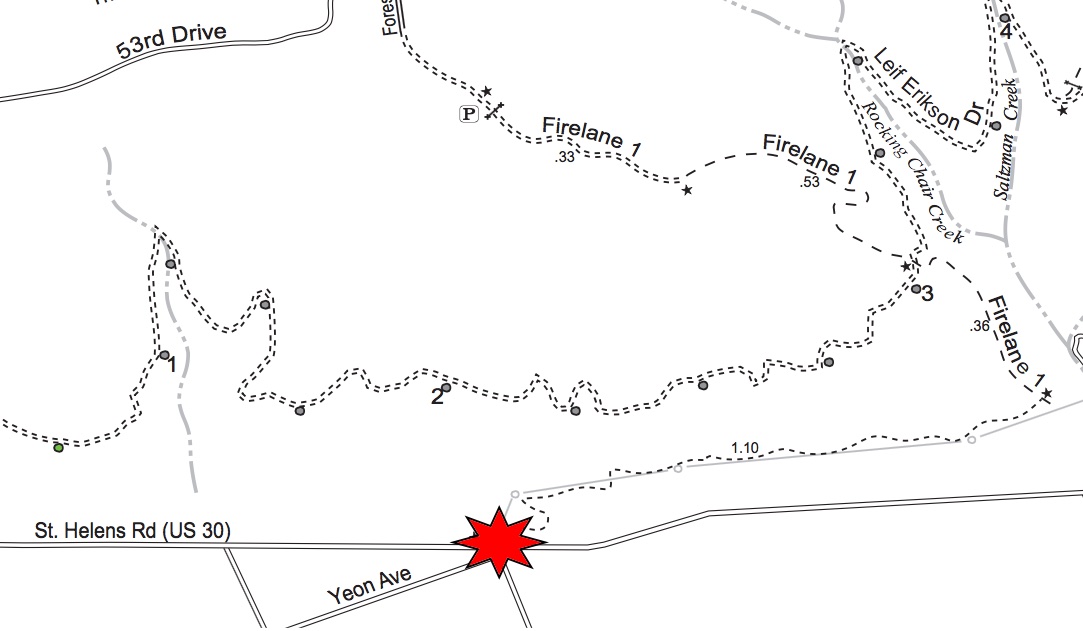
According to the Parks Bureau, this new project will include a nature center, an ADA accessible trail, and a parking lot (which Parks says will be big enough for schools buses so local kids can take field trips to the park). The location for the entrance will be just off Highway 30 at near the intersection of Yeon and Kittridge (about 3.5 miles northwest of NW 9th and Lovejoy). Parks purchased the lots, former brownfield sites that are now cleaned up, using Metro bond levy funds from measures passed in 2005 and 2014.
Advertisement
With an additional $800,000 into the project from Parks System Development Charges (SDCs), Parks can now move forward with surveying, site planning, engineering, permitting, and so on.
Any project that aims to improve access to Forest Park is worthy of our attention. Especially if you are interested in bicycling access.
This new entrance will be built right next to Firelane 1, which is legal for cycling. I’ve never ridden it, but my experience in Forest Park makes me think it’s probably not beginner friendly. A look at the Forest Park bike map tells us that Firelane 1 takes about 1.4 miles to rise 500 feet before it reaches Leif Erikson Road (the popular bicycling road that runs north-south through the park). That’s a steep climb that’s not feasible for most Portlanders.

Makes me wonder: Will Parks use this project as an opportunity to make Forest Park more bike-friendly for a wider range of users?
Let’s look back at the the 1995 Forest Park Natural Resources Management Plan (an official and still binding plan adopted by City Council) for some context. When I talked to a Parks planner about the project today, she referred me to the plan as the official document that will help guide construction of the new trailhead.
That plan called out this project as a “high” priority. Here’s what it says (emphases mine):
“Develop regional trailhead with parking for 20 cars, drinking fountain, and seasonal restrooms. Built multi-use trail up to Leif Erikson and Fire Lane 1 — to handicap standards, if possible. Pedestrians will continue on Leif Erikson and cyclists will continue on Fire Lane 1.
Arrange for possible use of old fire station or construct new building for use by organized events — runs, walks, bike events, etc. Study use of shuttle bus service from new parking area to other park access points. Service could be for small fee with buses capable of carrying bicycles.”
Judging by that text, I’d say bicycling advocates should pay very close attention to the upcoming planning process that will kick off in the coming months.
The Parks planner I spoke with today confirmed that the new ADA accessible trail is definitely still in the plans — although she didn’t say anything specific about accessibility improvements for park users on bicycles. If new trails designs are being built and funded, why not built one that’s open to bicycling all the way up to Leif Erikson?
Stay tuned. Parks will hold a public process to get input on design of this project. Current estimates are that planning will take up to two years and construction could start in 2017.


Considering that the entrance will be on a terrible street to walk or bike on and considering which elected official is currently in charge of Parks, I’d bet on that answer being “no”.
Adam,
you’re always soo negative!
I was thinking that this project is the perfect chance for us to actually tame that intersection a bit. I would be very surprised if this project did not come with some good improvements to safety on the street outside of it.
It’s easy to be negative when every bike / pedestrian project is half-done and dangerous.
Negative? I prefer 30% optimistic and 70% cynical. 😉
While I agree with you and would love to see some protected lanes on 30 and an improved intersection; based on past performance, I don’t have high hopes. Will PBOT and ODOT be involved in the planning process?
IMO..a 20/80 split is more accurate! While I tend to agree with you on occasion, J.M. has a valid point. You tend to be one of the first responders to posts here,and over time I have come to skip past your comments and move on to others first, as more often than not your outlook is too dreary to consider. This coming from a cynic such as myself!
Enter winking emoticon here….
Honestly, I am simply calling it as I see it. When something is done right, I always try to provide praise. It’s just lately, more negative things have been happening than positive things, so that’s how I’ve been reacting. Although, I will admit that my previous comment was a bit too cynical. 😉
“right” is a subjective standard though. Clearly there are differing opinions here on the need for protected bike lanes and the quality of other infrastructure.
A substantial portion of Portland will view this proposal with excitement, as MANY people drive to hike in Forest Park.
There will always be a subset of people for whom nothing is good enough. It’s as if they thrive on complaining on what others do, but do little to nothing themselves.
I use the term “Highly frustrated optimist”.
I like your thinking. It would be cool if there were bike and pedestrian improvements all along Hwy 30 between this site and the St. Johns Bridge so that the new trailhead would be as accessible as possible to North Portlanders. I kind of wish they had selected an access point farther north for that reason but this is the part of the park where the Master Plan calls for focusing active recreation.
The Forest Park Management Plan categorizes cycling as “passive recreation,” in spite of efforts of bike opponents to re-cast it otherwise.
Yes, but that wouldn’t push his agenda forward.
Where has the mountain biking master plan gone? How does the MTB master plan play into FP here? Are they going to take away even more trail from mountain bikers? FL1 is steep and if they clean it up to handle that many people, bikes will be able to go pretty fast on it – which will lead to more conficts, accidents, etc. I wish there would be some sanity regarding bikes in Forest Park instead of consistent bad decisions solely based on the rich neighbors and the small, but loud minority that Labbe, Houle, et. al., represent.
High value industrial zone freight parcels crammed in between the rail yard on one side and the Forest Park’s steep terrain on the other leaves very few if any options for making this area safer for anyone, let alone bikes and peds. I biked to work here for 5 years daily it is hairy.
(1) The same type of freight coalition that balked at the NE 12th Ave improvements will be out here in greater force
(2) Don’t even THINK of encroaching on the rail yard; tearing down the mountain will be quicker and cheaper.
(3) All 3 southern approaches to this area are rather hazardous:
..(a) NW Front Ave is a 2 lane heavy freight road with a dozen+ rail crossings at very shallow angles
..(b) NW Yeon has no bike lanes from Kittridge Bridge (where the red star on the map is; goes over rail yard) to I-405 but it is adjacent the rail yard so half of potential illegal turn maneuvers by cars never occur. The road stays clean and smooth with wide lanes. You just have to ignore the high speed traffic.
..(c) NW St Helens Rd from NW Nicolai to the Kittridge bridge has bike lanes and more dicey traffic, more driveway entrances and more right hooks than Front and Yeon combined. Probably because of the construction waste recycling center (very close to the red star on the top map) there was always an abundance of sharp tire popping debris in the bike lanes left for months.
Nope. It’s more important to spend the money paving paradise and building a parking lot. There’s no $$ left for those wimpy bikes.
I often take Front Ave to Kittridge and then turn north onto HWY 30 to access Saltzman on one of my loops. This could potentially keep me off of HWY 30 altogether, as I would be able to get up to Leif using this new access point. Front is a decent route, especially on the weekends.
I use that route, too Chris I! I like to ride it after work. With all of the new condos, apartments, hotel going in on the north edge of the west side, this road will get nothing but busier. The City would be smart to put in some robust bike infrastructure here from Kittredge south along Naito. It would be a great amenity with the new park, and bring more people to the park on bike.
And the road is so overbuilt right now. They could stripe bike lanes and turn lanes for the entire length of Front Ave and traffic would not be affected.
Soon as it’s completely enclosed by 8 foot chain link there go bikes forever.
Not really that enthusiastic. Why not locate it in Washington Park or a more accessible location. Why not put 1.5 mill into trail improvements? Is this pork to satisfy a political debt of some kind. Just don’t understand the purpose or location.
ALWAYS follow the money. Just as Dunthorpe folks don’t want mountain biking near them, tony NW Portland folks want fewer people clogging Thurman and nearby roads. This helps do that. No way a $1.5 million “gift” is used to bring more crowds to those areas.
Bingo.
A lot of people don’t want more cars in their neighborhood. Seems to be a universal desire.
This is a lot more accessible for folks who live in North Portland near St. Johns. Washington Park is easy to get to by public transit, sure, but I don’t feel like that area of town needs more investment in recreation options. Cleaning up Hwy 30 even in this small area will be great.
Yay… a parking lot…
I can think of at least two existing ‘official’ entrances to Washington Park:
1. SW Park Place at SW Lewis Clark Drive (i.e. the top of Salmon St.), and
2. The Hoyt Arboretum visitor center on SW Fairview just east of SW Knight.
I ride lower forest lane 1 (from Leif down to 30) all the time. Believe it or not, this section is the closest to singletrack that FP has (other than a small section of forest lane 5 and the area NW of Germantown). And I have never seen anyone hiking up from hwy 30 up to leif other than homeless people.
And now there is going to be a trailhead at the bottom and a parking lot. Shew. I can’t say that this bodes well for this section of trail remaining open to bike. I’d be all for this if this section of trail remains open to bikes. NWTA will try to keep it open.
And…whatddyaknow…Mitch Greenlick represents the people who live in the NW Hills…who I’m sure are thrilled with prospect of people not parking in their neighborhood to access FP (https://www.oregonlegislature.gov/greenlick/Pages/map.aspx)
I’m with you on that. One of the best kept secrets (might have something to do with the blackberry death brambles) for decent mountain biking. Now we can look forward to getting screamed at by even more hikers, and then having it closed to bikes.
Other thing I worry about is the increased traffic in and out of that area, as dirty 30 to St. Helens road is my regular commute. I don’t look forward to dealing with oblivious drivers coming and going from The New And Improved Official Forest Park Entrance.
Actually, there is a 3rd entrance to Washington Park: Lewis & Clark Circle, at the top of the hill behind the stadium (this is the way Tri-Met’s Line 63 gets into Washington Park). That intersection on US 30/St. Helens Road is a pretty busy place, with a lot of 18-wheeler traffic going thru there. A 14% grade uphill to Ericson sounds like a Tour de France climb, unless they find a way to rebuild it so it’s not so steep. You’d need guardrails up there, too. Another portal onto Ericson near the south end of Forest Park would make more sense!
Well, I’m all in favor of visitors centers and all.
As others have noted, the St Helens/Kittridge/US-30 intersection could use some love.
If you haven’t spent much time there (like me), you can get an idea of what it’s all about from Google Streetview
https://goo.gl/maps/Nl9kM
https://goo.gl/maps/E6KwD
https://goo.gl/maps/VRHs8
https://goo.gl/maps/wtL1O
How about some median refuges for pedestrians as part of the project? With 8″ diameter concrete-filled steel pipes to protect people on foot from the sweeping ends of long, heavy truck trailers?
Ted Buehler
Forest Park has long needed a nature center. For an example of what a nature could do for Forest Park, visit THPRD Nature Park, out in Beaverton. THPRD (Tualitin Hills Park and Recreation District in Washington County) Nature Park’s nature center for its comparatively small nature park is a wonderful facility that helps people learn, understand and increase enjoyment of nature in that park.
As for a Forest Park nature center in the suggested location, serving some role towards supporting use of Firelane 1 for increased access by bike to Leif Erikson road, for biking in the park, that could be done. It’s worth looking into whether a more gradual climb to Erickson, along the firelane route, could be accomplished with ride-able switchbacks, reducing the max grades to 14 percent or less.
May as well be up front though, about what might be the range of varied bike use that people would have in mind for an access trail like that. People that are thinking ‘mountain biking’, very likely would run up against significant obstacles to construction of such a trail, if that’s how they would hope to use it.
The people of Portland should probably give more serious consideration than has been given in past, to providing access to opportunities for mountain biking within the city. Great idea: locate some land other than this park, for mountain biking, arrange for the city to buy it and develop it for mountain biking. Ideas though, that appear to be efforts too slip past the city’s people, use of Forest Park for mountain biking sound like a recipe for failure.
Thanks for reporting on this, Jonathan. I will be very interested to see what happens to FL 1 as it is very steep for hiking and cycling. Given how impossible it has been to get any changes to trails there (cyclists can’t even get a single mile of trail shared without divine intervention), I am curious as to how easy it will be to make trail changes for non-cyclists and if we will be included.
Secondly, I hope this project coincides (and isn’t completed prior to it) with the MTB Master Plan and provide Parks with an easy opportunity to finally do something that benefits cyclists! Next to the parking lot there could be a pump track/skills area. Firelane 1 could be revamped and include a shared Blue Trail with a more technical, descending-only trail that parallels it for cyclists.
Yeon/Kittridge/St Helens is the literal worst intersection– i have to deal with it daily.
the Trimet buses that take illegal right turns off of St Helens onto eastbound Yeon are the best!!!!
especially when they expect me to wait for them to complete their illegal turns after i have walked halfway through the crosswalk –way to respect my right of way as a pedestrian!! <3 <3 <3
(complaints to Trimet and portlandsafe were met with positive double-speak, just so y'know. the bus drivers happily continue this behavior in order to get to their break area next to La Quinta ASAP muy pronto!!)
super looking forward to the "positive impact" increasing activity in this area will bring!!
😀
Bank on it! With park bureau involved with the neighbors to FP steep downhills ending in steps or stairs. Sometimes with the concrete stairs in the middle to break up the monotony of the climb or descent for the mountain bikes.
This only makes sense to those in NW Portland who don’t want FP visitors going through their neighborhood and parking on Thurman, and for those who just want fewer Portlanders in the nicest parts of the park. I suspect it will coincide to more limited access and parking on Thurman.
It’s a terrible access point for either pedestrians or bikers – the bottom of an ugly trail with power lines and industrial views. I’ve been up and down FL1 – it’s not pretty, not inviting, and requires climbing hundreds of feet to reach the pretty parts of the park. Bringing school kids there is a disservice to them.
The NIMBY politics surrounding FP goes on. It’s also remarkable in light of claims about insufficient funds to do things in the park.
This is all very true. This is a great representation of what FP politics looks like – just pure NIMBYism. This access point is nowhere near as friendly to entering the park. Any other trail access is quite a hike from here, unlike the current entry point at the end of Thurman which has _many_ access points in under 1 mile and no large elevation gain. This is going to be a failed attempt unless there is a large policing effort to cutting people off from entering at Thurman and/or they start adding many more trails near FL 1.
This seems like a complete waste of money for what little benefit it provides the city and the overall management plan needs to be revisited with consideration to all users – not just runners/hikers/neighbors of FP.
One last question – where does the Mountain Bike Master Plan fit within all of this? When is MTBing going to be considered and talked about in this process?
Just wondering the same thing. How do we find out ANY info on the MTB Master Plan? Some communication regarding it would be nice, especially given the history of off-road cycling in Portland.
I feel for the school kids – who would chose to start their FP visit there other than those bussed there against their will?
Seems like Saltzman Road would be a better place for an entrance and parking lot. That is a more accessible trail.
I look forward to seeing this develop. It should benefit all to have a recognizable entrance gateway and nature center for Forest Park.
it should include some mountain biking. maybe only cross country style, but it should include something for people on bikes.
Odd how they claim that the original forest park plan prevents building new trails. Unless it suits their objectives.
Actually, I’m surprised nobody has called out the egregious math error. 500 ft of climbing in 1.4 miles = 6.76% grade. Tough, but doable.
Look at the grade profile — it drops from 950′ at mile 0.6 to 200′ at mile 1.6.
That’s 750′ in 1.0 miles.
750/5280 = .142 = 14.2%
For comparison, this is about twice as steep as the ride from Portland Bible College up to Rocky Butte.
Ted Buehler
I can attest from personal experience, 15% on a pave grade like that is pretty rough…especially for a mile.
We already have roughly seven (?) nature centers within bussing distance:
Audubon Society (Portland / Forest Park)
Hoyt Arboretum (Portland)
Tryon Creek (Portland)
Tualatin Hills (Beaverton)
Cooper Mountain (Beaverton)
Jackson Bottom (Hillsboro)
Tualatin River (Washington County)
John Inskeep (Oregon City)
If FP had a trail network suitable for its best and highest uses, it would attract those uses without a $1.5m “front door.” I don’t think FP needs any sort of Disney center, or door, anything except trails to serve all Portlanders.
Would $1.5 million in public dollars really buy much more than a poorly paved lot and an interpretive sign?
Well… to be clear, this $1.5 million only pays for them to start survey and initial engineering work and begin a public process. The total cost in the end is impossible to know because they don’t have a plan or a design yet.
That makes more sense. I appreciate how politics and earmarked funds work, but $1.5 million would really go a long way on actual trail building instead of some fancy building in industrial NW.
Hey, did this get built? Got an update?
I biked all of Firelane 1 a few months ago and there is definitely not a nature center by Hwy 30. A short firelane to the highway, that is it.