(Photos © J. Maus/BikePortland)
After what officials say was a successful pilot project, the Bureau of Transportation has decided to bring back the temporary biking and walking path on Naito Parkway.
“PBOT can use this and learn from this experience as we consider other improvements in the central city and other innovations throughout our system.”
— Dylan Rivera, PBOT
Just like they did back in May, PBOT will partner with Better Block PDX, a non-profit group that takes an open source approach to “creating inviting and interactive places that challenge the notion that streets are only for cars.”
The Better Naito sequel will start on July 21st and run through the 27th. The timing has been coordinated specifically to coincide with the Oregon Brewers Festival, an event that draws about 85,000 to Waterfront Park over five days.
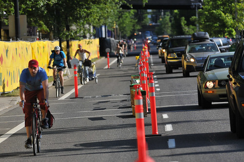
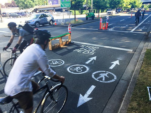
From Tuesday the 21st to the following Monday, PBOT and Better Block will install a 15-foot wide, two-way multi-use path for nine blocks (one-half mile) between SW Salmon and Ankeny. Better Block’s Ryan Hashagen says they’re taking lessons learned from last month’s project to improve the experience for everyone this time around.
Advertisement
“We’re working closely with the Brewfest to have their lines queue off of the path,” he shared in a phone call yesterday, “And we’ll have more signage this time to make everything more predictable.” Hashagen also said this time around they’ll add more placemaking features such as seating in Waterfront Park south of the Festival ground.
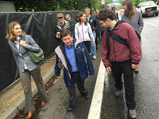
Commissioner Novick and ODOT’s Kelly Brooks on Naito
Parkway last month.
The new path is necessary, organizers say, because the existing path along the river in Waterfront Park is already at capacity and Naito lacks a sidewalk.
Timur Ender, transportation policy advisor for Commissioner Steve Novick said the Better Naito project is all about safety. “40 percent of Brewfest visitors take transit, 30 percent are from out of state, and 50 percent are female — this is the type of demographic that will directly benefit from safety improvements.”
PBOT spokesman Dylan Rivera said the city’s partnership on Better Naito is “part of our Vision Zero implementation.” Rivera said working closely with the community on a pilot project like this and devoting staff and engineering expertise to it is, “Not the type of thing we’ve typically done.”
The idea behind Better Block’s work is to help people re-imagine public space. Instead of a long, drawn-out public process for a project that only exists in mock-ups and concept drawings, Better Block gives people a real-time experience with a new streetscape, then gauges feedback and collects data to measure its results. Their project on SW 3rd Avenue last year was so successful it has sparked local support for permanent changes.
Better Block, PBOT, and Commissioner Novick’s office are working together once again because feedback and data from the previous Better Naito project have been very positive.
Ender said their office received only one call about the first Better Naito implementation. It was from a kindergarten teacher who took children on a field trip to Waterfront Park and was very pleased at how it improved their safety. Ender added that other feedback from Twitter and via email was mostly positive.
As for data, Better Naito led to a 108 percent increase in bicycle trips compared to the city’s 2012 counts (taken northbound at SW Morrison). When the two-way path was opened (during the final few days), they counted one bicycle trip in the southbound direction every 18 seconds (in the temporary path, not counting the existing southbound bike lane or the waterfront path).
To better understand impacts of a 15-foot wide path on Naito, the Better Naito project will also count how many people using cars are diverted off the route and onto side-streets. Similar to last time, this project will work with Portland State University urban planning graduate students to count bicycling and walking data.
This type of real-world data and feedback is a goldmine for PBOT planners, politicians, and engineers as they embark on their Central City Multimodal Safety Project.
And it’s not costing the city much at all. The first Better Naito cost only about $15,000 and it was paid for through sponsorships from Clif Bar and People For Bikes. This time around, Hashagen says they’re using leftover funds from those corporations as well as donations from new partners.
Does this double-dip by the City of Portland on Better Naito prove they’re seriously considering a new — and permanent — path? “We don’t have any plans for the future at this point,” Rivera said. But he also mentioned that PBOT is learning a lot and “closely monitoring” what they hear from the public. “PBOT can use this and learn from this experience,” he added, “as we consider other improvements in the central city and other innovations throughout our system.”
From PBOT:
-
Have your say about the Naito Pilot Project:
Twitter: #BetterNaito
Email comments: NaitoParkway@portlandoregon.gov
Web site: portlandoregon.gov/transportation/naitoparkway
Facebook: Portland Bureau of Transportation
Leave a message by phone: 503-823-4321


Seems like it’ll be really narrow with pedestrians and two-way cycling on the same lane. It was narrow before.
peds use the bike lane. bike use the auto lane.
It seems to me that this effort should be paid for by the Oregon Brewers Festival. The PPB recovers a portion of their costs for additional traffic control from the sponsors of athletic events. Isn’t this simply a traffic control measure the need for which is caused by a special use on an adjacent city park?
Oregon Brewers Festival is a main sponsor of this round of #BetterNaito. They have stepped up financially and were at the table working to make a Better Naito for their festival attendees and everyone enjoying our Waterfront.
I love that this is being done again and can’t wait for it to be permanent. My advice would be to have the permanent set up complete by the time Tilikum Crossing opens so people riding over the new bridge won’t be forced into crowded Waterfront Park. Additionally, Better Naito should take up the entire northbound two lanes with a wide two-way cycle track and a wide sidewalk. People driving can get the two southbound lanes. If foot and bike traffic really make up as much as PBOT claims, then they should get more space.
That’s a pretty expensive project you’ve described and an impossible timeline for completion.
I wish they would have implemented a similar plan during the Waterfront Blues festival. I know that event is little further south in the park but the impact on bikes and pedestrians NOT attending the festival is huge…and dangerous for all.
This (or something similar, yet better), should be permanent. I’m tire of the “test diverter,” “test bike lane,” “test blah blah blah.” Just do it already. Or I’ll sic Shia LaBeouf on the city council.
I just got all the chalk paint out of my pants from the last one. Hoping our city that works doesn’t continue to rely on volunteers to make our transportation system work. Let the pros put down the real paint.
AFAIK the markings on the pavement have to be removable with water for projects like this, so “real paint” is not part of the program. Pity because “real paint” is lots cheaper than the chalk stuff.
+1 for permanent, and BTW, just emailed feedback also
If this was made permanent I would think there’d be very little use during the winter months… The existing path along the river in Waterfront Park is pretty much empty when the wind is blowing, it’s raining, and cold outside during those winter months. I also like being able to ride the existing path right next to the river versus having to ride a new path right next to a carbon-monoxide belching vehicles being driven by people texting and drinking soda.
The riverfront path is destined to become a slow zone – walking speed only.
To me, that too would be overkill during the Winter months when there is almost nobody on that path when it’s raining, windy, and cold outside. Well, scratch that… there might actually be a few homeless camp bike chop shops in operation along the path then too… I fully agree that it should be walking speed, or walking only for that matter, during large events and all bike traffic should get temporarily diverted onto the Naito bike path.
I’m not clear how far south people think the Naito bike lanes should extend.
During rush hour, south of the Hawthorne Bridge, north bound Naito is terrible grid locked mess. It can take 30 minutes to drive the half mile from Hwy 26 to get on the Hawthorne Bridge (just try it some 6 pm on a weekday). That portion of Naito cannot lose any vehicle lanes, and it needs some serious reworking of signal timing to improve the function of the existing lanes.
I’m also not clear why the best solution to insufficient bike capacity along Naito is to be found in the roadway of Naito, rather than on the edge of Waterfront Park.
A bi-directional bike path and a pedestrian sidewalk could run along the west side of the park. Large festivals could be required to place their fencing 12 feet further to the east. This would produce a bike path curb-separated from car traffic, and no reduction of car capacity. A win for everyone. The only trade-off is that large festivals would get a very little bit less space, which will only matter for a few weeks each year, and then only to a handful of events.
So, you start out with gridlock south of the bridge, then describe gridlock north of the bridge.
The bridge onramp traffic blocks one lane of Naito northbound. The solution might be a signal on the bridge, but that doesn’t mean Naito north of the bridge has too much traffic.
The portion of Naito south to Kelly and Barbur is not slated for any lane conversions.
Waterfront park is best used for pedestrians and slow bikes, not commuter cyclists who want to go fast, just like the drivers.
The large festivals still need space for truck loading and unloading, like in the travel lane next to the park, which is frequently closed during the large festivals. On-parking truck pads may be one solution.
The current vehicle demand for Naito indicates it only needs one lane for autos. Having a world class bike facility on Naito can also reduce auto demand on that roadway and there looks to be capacity all the way to Front and beyond.
I’d love it if the protected lanes could connect SW Moody to NW Front! That would mean a continuous cycle track from Tilikum to the Pearl/NW. Anecdotally, I ride along Naito/Front near the Fremont Bridge during peak hours and rarely do I see enough cars to warrant the four lanes the road has there. I’m willing to bet the data show something similar.
Why would go that way off the highway to get to the central eastside?
Just loop over the Marquam and get off at SE Water on I-5 just before the Banfield exit. Or get off at Civic Stadium turn north on 4th then right on Madison for a straight shot. Unless it’s really bad (bridges, snow, or major crashes) it never has taken me a half hour on either of those two routes.
Or are you using trying to use the Hawthorn to skirt a backed up Ross Island? That is always a losing strategy.
I still think Natio from the Hawthorne (well Harbor actually) to the Steel is near useless because most the traffic is just what I describe above- people backing it all up, trying to avoid other backed up bridges. There is hardly any parking or businesses that face the street (The Hilton is the one really big exception).
Just make that stretch a paved extension of the park. Add some playgrounds, the proposed beach, perhaps a permanent amphitheater and what not – and with a paved section for the festivals you could extend the festival season since it wouldn’t be such a wash out in the winter.
What the hell, Novick?
“and 50 percent are female — this is the type of demographic that will directly benefit from safety improvements.”
Because women are… more… delicate? I don’t even know. Can we go with:
“and 100% are human – this is the type of demographic that will directly benefit from safety improvements.” instead?
I thought I was the only one who had to give that a double take. And while it’s by far the most absurd part of his statement, the whole thing is odd, really. Why are we especially concerned about tourists? And why the people going to the festival, versus the people using the Better Naito bike path? Oh, right, because our leaders aren’t allowed to use the “B” word.
““We don’t have any plans for the future at this point,” Rivera said.” 7/17
“As for the more ambitious, two-way biking treatment, the words I’m hearing from PBOT’s Pearce are very reassuring. He said they are watching the data very closely and a two-way protected bikeway on Naito Parkway could be considered in their upcoming Central City Multimodal Safety Project (a.k.a. the project that will create a network of protected bike lanes downtown).” 6/5
so did they change their mind?