(Photo: J.Maus/BikePortland)
![]()
Part of our series of guest posts, America’s Next Bicycle Capital, where we share community voices about the future of biking in Portland.
This week’s guest writer is Terry Dublinski-Milton, land use and transportation chair of the North Tabor Neighborhood Association.
For years, Portland has been ahead of bicycling infrastructure curve. Recently, as has been reported on BikePortland, it seems we have lost much of our forward movement. But this may be changing.
As the transportation chair for the North Tabor Neighborhood Association, I knew a Transportation Systems Plan update was coming as part of the citywide Comprehensive Plan update. So over the past year, we’ve made significant progress towards our goals of having an integrated, interconnected network of bikeways north and east of Mount Tabor Park.
This is the story of what we as a community have done. I hope some of you reading this will take it as a possible model for neighborhood activism across the city.
Located between the Banfield transportation corridor and the Burnside High Crash Corridor, North Tabor is predominately in Northeast, but is part of the Southeast Uplift neighborhood coalition. SEUL does not have an overall plan for bikeway conductivity like East Portland in Motion or the developing Southwest In Motion. So I decided to make one … at least for my little region of the city.
Portland’s 2030 bike plan, though a good document, has lots of gaps in its greenway network. My neighborhood is in one of those gaps. I used survey outreach we had done, in which North Tabor residents said they wanted better access to regional schools and parks, as the basis for a letter about growth and transportation.
This letter was unanimously passed by the North Tabor Board of Directors and the city took our comments seriously. This document has formed the basis for neighborhood planing and action over the past few months:
- We endorsed buffered bike lanes on East Burnside as part of a future roadway modernization of the high crash corridor, ensuring its status on the highest level of regional bikeways in Metro’s Regional Active Transportation Plan.
- We filled one of the 2030 bike plan gaps by creating the idea of a 60s greenway on 62nd and SE Scott Drive from the 60th street MAX station south to Mount Tabor Park, creating a greenway corridor the way to the city limits and the Springwater Corridor. It’s now been added to the TSP and is on the project list for possible construction over the next 4-6 years.
But here’s my main motivation for telling this story: in recent months I worked with my cohort to the east in Montavilla to cross-endorse their priorities, and they did ours. As a result, the North Tabor and the Montavilla Neighborhood Association, which together represent over 22,000 residents, have now endorsed a greenway/bikeway network where nearly no one would be more than a half-mile from a bikeway. The vast majority are within a quarter mile.
What are these projects?
- We endorsed a roadway modernization from 67th to 74th on Halsey as part of the current repaving project. Halsey would get a new curb-tight bike lane connecting the disparate grid north of Glisan, giving us safe bike access to the regional parks and neighborhoods to the north for the first time.
- We endorsed the 60s as the highest priority greenway for North Tabor to fill the gap between the 53rd Greenway and the 70s in Montavilla.
- We endorsed turning 80th Avenue south to PCC Southeast into a high-priority greenway to connect people of all ages to schools and to help mitigate Portland’s much-maligned 82 Avenue.
- We endorsed improvements to the 70s to give more assured cyclists a clear route north and south from the Montavilla business district.
- We also included the needed east-west improvements like finishing the Davis Greenway in some way as an all ages-spine to 80th on the east and Vestal Elementary.
In total, we endorsed a connected network with relatively bike-friendly grades and system redundancy in case of construction.
Advertisement
What have I learned form this experience?
Networking works.
We need equity, so all neighborhoods have access to quality bike facilities that are conductive to those surrounding them. Residents know this and care about it.
I also learned NOT to believe the anti-bike hype. At least in central-east Portland, there has been very little resistance and much excitement. We are looking forward to these improvements, and would like the entire city to have the same benefits that will hopefully come to us soon.
That’s not to say there have not been naysayers, there always will be. One can not run a city on consensus, and whatever is built will have some complaints. But at least in our neck of the woods northeast of Mount Tabor Park, active transportation has become a regional priority.
Now, I’m taking these lessons on the long road to bringing this type of conductive network south of Mount Tabor. Central South Portland has real problems with bikeway conductivity and significant gaps in the 2030 bike plan greenway network.
Some of us most embedded in the transportation systems plan have been meeting to come up with a strategy to fix those gaps. I hope to help bring the greenway grid network, which has so culturally embedded itself in inner east and north Portland, to those neighborhoods to the south. This is fertile ground for bike activism as these neighborhood feel left out and want these improvements, whether it is the 60s greenway to Mount Tabor Park or bike lanes on 72nd.
(via Facebook)
Do you live in central south Portland? If so, we could use your help. We will need to network at least a half dozen neighborhoods together into a series of priority routes. How about a Clinton Promenade connecting the Clinton-Woodward Greenway east directly to the Division Street MAX Station? What about new crossings of 82nd to the I-205 path? The 2030 bike plan calls for bike lanes on 20th from the Powell MAX station north past Sullivan’s Gulch. Does this sound good to you?
Now is the time to get involved in Southwest in Motion, or similar concepts in other areas of the city. Final comments are due March 13th, so now is the time to contact your neighborhood association transportation’s board and ask to be added to the agenda to talk about greenways to your parks and schools – or whatever active transportation project you would like to see built in your neck of the woods over the next twenty years.
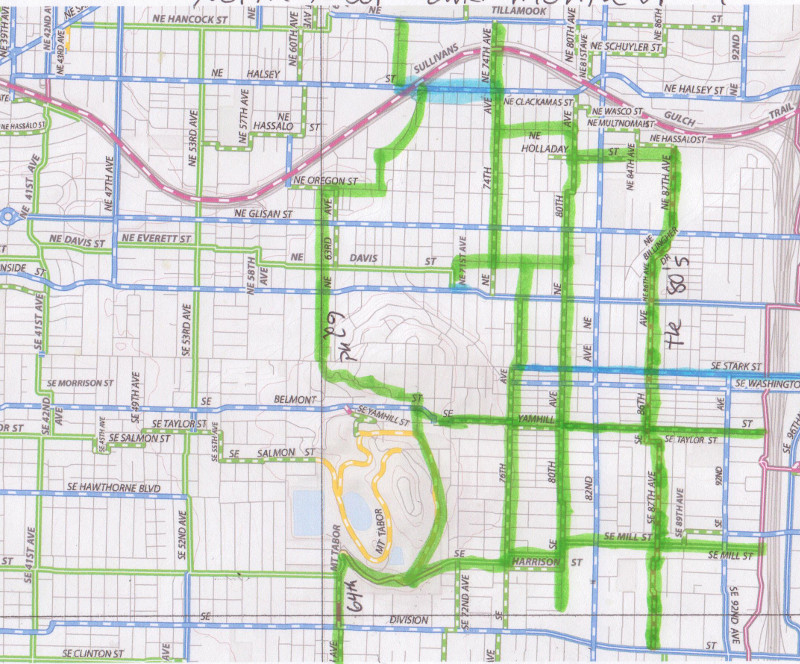
Here is the wonderful Greenway Grid Network that I designed and have been so fond of over the past few years. This is the map, based on the 2030 bike plan with the gaps filled, that we worked from. If you live between I-205 and the Willamette River, it’s a great baseline to modify for your own ideas.
The routes here may not be the best for every neighborhood. But they work, they’re affordable, and bring equity to all of central-east Portland. Network in your own neighborhood and network with your neighboring associations. The more cross-endorsements that happen, the more the city will treat active transportation with the seriousness it deserves.
If you’d like to add your voice to this series, get in touch via email: michael@bikeportland.org.


Terry has done an ridiculously outstanding job with his planning on this work. He deserves a lot of praise for the time and thought he has put into this. And SE Portland will certainly be better off for his work!
The only sad part is that it took a private citizen to volunteer his time to do all this.
Thank you. I think we are really having an effect….and just need to keep at it.
I live on one of the streets the official map has as a path. I’ve always been frustrated by the lack of safe riding in this area. Glisan and Halsey aren’t safe to ride on, the area gets ridiculously steep in some places and there are streets that just don’t go through.
Most of this map I like. 63rd between Oregon and Davis is fine if you’re a fit, hill climber but for the casual rider on a city bike you’ll be wishing you were walking your bike. I’d like to see a lane on 60th at least for a few blocks, say between Davis and Halsey. 60th is one of those rare streets that crosses I-84 and there’s actually room for a bike lane if the city wanted to add one. I like the idea of Oregon street being a Neighborhood Greenway. 68th can be a little higher on traffic and could use a bike lane. Where 68th meets up with Halsey is also pretty dicey with an inclined, curving street, high traffic street and freeway exit all in the same location. For the LIFE of me I can’t understand why the city had 76th as a bike route and not 80th. 76th is higher traffic and hilly, 80th is almost devoid of cars and has a FIVE FOOT elevation gain between Halsey and Division. Mill is also a great street to ride a bike on, it has light to medium traffic, is wide and lined with beautiful trees and connects with the 205 path. At night, however, trees can make the darker in the summer months when the leaves cover the street lights.