but it comes with a detour off the Westside Trail.
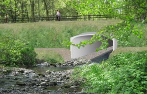
(Image: Multnomah County)
Multnomah County has announced a major detour that will impact people who ride bicycles between downtown Portland and the Sellwood Bridge on the west side of the Willamette River.
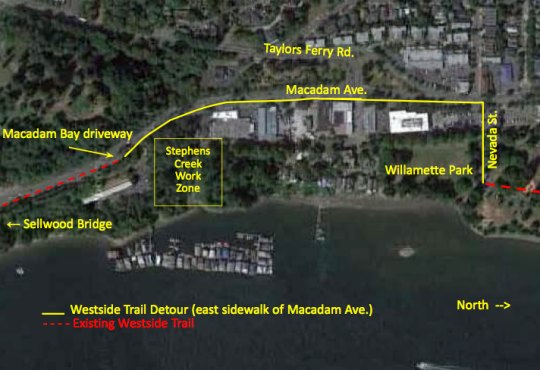
As part of the Sellwood Bridge project a County contractor is replacing the culvert that crosses Stephens Creek under the trolley tracks between SW Miles Street/SW Taylors Ferry Road. Crews have put a detour in place (see graphic below) that will impact users of the Westside Trail until at least early 2014.
County spokesman Mike Pullen says users of the Trail who are headed southbound from Portland will be directed off the trail at SW Nevada Street and onto the sidewalk on the eastern side of SW Macadam Avenue. Trail access will begin again at the driveway to the Macadam Bay floating homes.
“We know this detour is not ideal,” says Pullen. He adds that the County plans to improve the detour with a temporary bridge across Stephens Creek in early 2014, “so we can reopen most of the old trail while we complete our project.”
Because riding out of one’s way and against traffic on the sidewalk of a busy arterial, Pullen says the contractor has already reported “problems” with people entering the work zone and trying to follow the existing Trail route. Pullen says it’s unsafe to enter the work zone. “I think the detour signage and fencing are pretty clear.”
Pullen is asking for feedback on the detour and wants to hear your comments if you have ideas on how to improve it.


I would take this time to point out that the Multnomah County Bicycle and Pedestrian Citizens Advisory Committee is meeting this Wednesday at 6:30pm and allows a public comment period for members of the public to voice their concerns on any issues involving the county. This meeting would be a great opportunity to provide input.
https://web.multco.us/transportation-planning/bicycle-and-pedestrian-citizen-advisory-committee
Meetings are at 6:30pm on the 2nd Wednesday of the month (that’s THIS Wednesday) at the Multnomah County Building – 501 SE Hawthorne in the boardroom adjacent to the main council chamber (1st Floor). Since the meetings are after normal business hours, buzz the intercom next to the door and security will let you in – say you’re there for the bike/ped meeting, and they will point you in the right direction.
Unless they’ve improved the signing from a couple weeks ago, no, not clear. I happily toodled along southbound until I hit Miles, where it told me there was a detour, which directed me to take a right. I did so, and the trail loops north! Hooray! I stopped, looked around, and then up a steep hill (not a trail, mind you), and saw a sign over a set of tracks, which I had to carry my bike over. I found myself in a parking lot, with a sign pointing left/south, telling me that was the detour. Nothing said I was to take the sidewalk, and the sign pointing south was at the east side of the parking lot.
Clarity….is not something the detour signs had. Sorry, but no.
Thanks for the feedback. We will check out the signage you mention and see if it needs to be adjusted.
You might consider moving the detour sign at the end of Willamette park back (south) a block. This would route people up Miles St off of Miles Pl. (Not to be confused with Miles Ct. Egads!). It doesn’t solve the larger issues on Macadam, but at least then you have a choke point at which to put a sign.
As of Friday, I didn’t notice detour signs routing me up Nebraska.
i rode on the sidewalk this morning and it was awful. It’s too narrow with telephone poles and people waiting for the bus.
feralcow is not exaggerating. It’s ridiculous for one-way bike traffic, let alone two-way. It’s (maybe?) a 6 foot sidewalk.
ditto, those sidewalks are horrible for bicycling
it is dreadful indeed, but something of a luxury once you get past the 3′ wide, two way traffic on the bridge being replaced.
I just went through on the weekend when they weren’t working. It was passable a couple of weeks ago. Even if you do that, you still end up on
the narrow sidewalk before you get to the bridge. However, it also looked like they might be converting part of the rail bed to trail, but I’m not sure when that’s going to be finished.
As part of the project, a section of regional trail will be built between the bridge and SW Miles St. The new trail will not open until 2015. By early 2014 a temporary bridge across Stephens Creek will allow us to move the detour off of Macadam and back on its old alignment.
Plain and simple, this is blatantly unsafe for everyone. The sidewalk has numerous restrictions to traffic flow including phone poles, construction signage, and lots of people waiting for the bus in the morning. Putting two way bike traffic on this sidewalk is a recipe for disaster!
And of course if I take the lane on Macadam I will have to deal with road raging drivers who are going far over the 35mph limit… and that is only in the morning. Just try that southbound during the afternoon rush hour!
Is the riverfront path closing too? This morning I rode down SW Miles and through the park, and though some mega cranes had blocked the road the path was still usable. Luckily my morning commute is early but the afternoon is going to be a nightmare.
Bikes on the narrow sidewalk are bad for all parties and someone is going to get seriously hurt. For my own safety I may just have to start driving again, during prime bike season.
Oh, c’mon, folks. It’s not ideal, but it’s do-able and with a little common sense, it’s perfectly safe. The slight inconvenience is a small price to pay for the huge improvements that we’ll experience in a few years.
No, it isn’t perfectly safe. It’s really quite hazardous.
As encouragement for the contractors to put in this temporary bridge sooner PBOT needs to jersey barrier off an official bike lane detour.
If it is going to be there longer than a week it needs hard, not fabirc, orange construction zone signage and lane restriping as mandated in the federal MUTCD for cars AND BICYCLES and further required by state law.
Anything less is a fraudulent waste of taxpayer’s dollars when the inevitable injury or death occurs herr.
I agree that there should be better accommodation for cyclists through this area – though the jersey barrier / lane striping would require ODOT approval since Macadam is a state highway. I plan to ask the county about this issue.
Sadly, even this narrow sidewalk will not be available as a path of travel after the Sellwood Bridge and the new trail location are completed. The county plans to remove the existing sidewalk that is south of the Macadam Bay driveway. (Instead, they could have connected that piece to the bridge, but chose not to for budget reasons.) I believe they even plan to remove some of the sidewalk north of the driveway. I guess they really want to, at that point, force you to use the trail through the woods, even at night, etc. I bet there are some folks, at some times, who might prefer walking along Macadam to the isolated trail location.
Hi Doug,
Do you have a source for that? If it’s true, I’d like to bring that up at the county bike/ped meeting. Thanks.
No it’s not safe. It never has been. I remember riding this back in the early 80’s. Yea it’s a temp. detour but unacceptable for both ways. Traffic speed for cars needs to be reduced in this section. Then at least a North bound lane set up on Macadam & the s outhbound only use the sidewalk.
Take the lane, take the lane, take the lane. Please for the love of bicycling take the lane. It’s an absolute messy situation, and this “detour” is 100% bad of which 99.9% of the badness is due to the existing infrastructure as commenters above me have mentioned. Please take the lane if you feel up to the task.
That’s easy for me to say, since the Springwater is much more convenient when I’m on a bike. I do often find myself in a car along Macadam and absolutely appreciate the people on bikes who take the lane. I’ll smile and wave at you even!
Could the 25 mph work zone speed limit be extended and enforced all the way to Nevada Street? That way bikes could more safely take the lane.
Thanks to all the Bike Portland readers who submitted suggestions, comments and complaints about the west trail detour north of the Sellwood Bridge. The project team is looking at possible improvements to the detour. We’ll report back with an update soon.
Thanks to Bike Portland readers who offered comments and suggestions for improving the westside trail detour that is in place between SW Nevada St. and the driveway to Macadam Bay. The detour is needed during replacement of a culvert that carries Stephens Creek under the trolley tracks and a future regional trail. The culvert is being replaced as part of the Sellwood Bridge Project.
The trail detour along the east sidewalk of SW Macadam Ave. will be in place until the culvert is replaced and a temporary bridge is installed across Stephens Creek. In 2014 trail users will be able to use the old alignment. The new regional trail between the bridge and SW Miles Street will open by 2016.
The project team will be making the following improvements to the trail detour:
• Remove vegetation growing over the sidewalk between Nevada St. and Macadam Bay (in the next week).
• Add an asphalt patch across the trolley tracks along the detour route between Willamette Park and Nevada St. The consortium of agencies that own the property have agreed in concept to the fix but they need to see the details. This should be completed in July.
• Close bus stop on south side of Miles St. This should be done in July. The nearest bus stop is two blocks north.
• Extend the 25 mph construction zone speed limit from Macadam Bay to Miles St./Taylors Ferry Road. This request is being submitted to ODOT for a decision. As the project limits end here, extending the speed zone north of Taylor’s Ferry is not supportable.
Some users suggested they still prefer using Miles Street. Trail users who prefer Willamette Park and Miles St. to the Nevada St. detour are allowed to use that route, which remains open. To minimize conflicts with the trucks using the haul road entrance at Miles Street, our recommended detour route is Nevada St.
Thanks again to readers for the comments and suggestions.