(Photo © J. Maus/BikePortland)
Multnomah County is looking for public input on transportation and land use issues on and around Sauvie Island. With the area being one of the most popular bike riding destinations in the region, this could be a golden opportunity to make the riding even better.
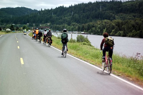
Sauvie Island is an agricultural and wildlife gem situation about 17 miles from downtown Portland. Its beautiful roads, expansive views, farm markets, and other attractions attract a lot of city traffic. There are also residents on the island who use the roads as part of their daily travels. As is often the case with narrow rural roads, sometimes tempers can flare between people on bikes and people driving cars. Locals sometimes resent people that don’t ride single file and visitors often complain about people who are rude when passing and/or who drive without regard for their safety.
Nearly seven years ago, in a story titled, Solving the Sauvie Island Problem, I wrote, “This is a problem that is going to keep getting worse until something is done about it, and I don’t think we should wait until someone is hurt or killed before focusing our attention on a solution.”
This planning process is our chance to address these issues.
Joanna Valencia, a senior transportation planner for Multnomah County told us today that they’d love to hear about bicycling issues. “We want to get an idea of what the issues are out there.” The input received will be forwarded to the Multnomah County Board of Commissioners. Valencia added that this process will help inform an update of the area’s Rural Plan and Transportation System Plan (TSP), which hasn’t been updated since 1997 and 1998 respectively.
That 1998 TSP (PDF) pointed out the area’s popularity for recreational riding. It also acknowledged the inadequate safety of the roads and recommended widening shoulders. Here’s an excerpt:
“Apart from U.S. 30, there are currently no roadways in the area with shoulders adequate to accomodate bicycles or pedestrians. Improved facilities are needed to accomodate pedestrians and bicyclists, particularly recreational uses. Projects to add shoulders will increase safety for these and other transportation modes.”
In addition to improvements to roads on Sauvie Island, we need real bikeways on Highway 30 and the St. Johns Bridge (both of which are ODOT facilities) to connect the island to St. Johns and the rest of Portland.
The County has a short online questionnaire and they’ve scheduled an open house for Thursday, March 7 at the Sauvie Island School (14445 NW Charlton Road). Learn more here.


It will probably never happen, but really, the most awesome thing EVER would be a bike/ped bridge from Sauvie Island to Kelly Point Park.
…or a bike ferry from Sauvie Island to Frenchman’s Bar Park in west Vancouver.
Todd, funny you should mention that. About 20 years ago a certain nautically-inclined individual, Capn’ Dan Weimer i believe was his moniker, was trying to do an ad-hoc ferry service for cyclists along this route. We booked an excursion, and he ran 4 of us over to the Sauvie beach on his skiff for $20 – total. It was a fabulous ride, and navigating the sloughs and the channel was great fun.
Thanks, Cap’n Dan, wherever you are.
Hmm, remember it is a shipping channel…
Thanks for the heads up, I went and filled out the survey.
My wish list, in no particular order: wide shoulders on Sauvie Island; protected, or at least not very narrow, bike lanes on Dirty 30; and reasonable/not terrifying access on the St. John’s bridge.
Bridge between Kelly Point and Sauive would be great. Even better: using some paint and making two lanes one lane with advisory bike lanes dutch rural style: http://wiki.coe.neu.edu/groups/nl2011transpo/wiki/e2b66/6_Advisory_Lanes.html
Only takes some paint. Cheap, fast, worth a try.
Advisory/shared bike lanes may only take some paint, but they would require a whole bunch of education for the typically buzzed drivers coming back from the Sauvie Island beaches.
I would love it if Sauvie’s could be regarded as one of Portland’s active transportation assets. If we had an off-street MUP connecting downtown and the island, and either a MUP or wide shoulder bike lanes, this would be a huge tourist attraction. “Rent a bike and ride to the farms outside of Portland”. It would be huge with tourists, particularly those from Europe.
I avoid riding SI after 8:30-9:00am generally and definitely during harvest season(s). Which really means I just avoid SI.And I even live in St Johns!
In addition there needs to be a bike friendly campground on the island…we group rode out there last year only to find the existing camp ground had recently changed hands and would not allow us to tent camp…even though they had vacancies AND their sign still said tent camping allowed (or similar).
sorry to hear that – Adventure Cycling / Willie Weir did a nice piece on it a couple years ago, riding out of Portland to stay at that campground.
Protected bike lanes on Sauvie would be fantastic. I think it’s currently a fairly crummy place to bike because there’s zero shoulder at all, and the 5% of drivers who don’t want to share the road can make things fairly unpleasant. I find that less experienced cyclists seem to prefer the low traffic of Sauvie, while more experienced cyclists are happier on 30, which has a wide shoulder to offer protection from its heavy traffic.
As a regular weekend visitor to the Island to swim the dog and sometime rider of a bike there, I haven’t really encountered any conflicts (If driving, I’ll slow to whatever until its safe to pass with plenty of room), but I can see the potential and wider shoulders would be ideal (I’d imagine an off road MUP would be a non-starter given the lack of connectivity of public land).
I’d be curious about what issues would be involved in a widening solution? Does the county have enough easement access/rights to widen shoulders? Would the new levee regulations affect widening where the road tops the levee right off the bridge or out near the Reeder beaches?
My last trip to Sauvie for bicycling found me hugging the edge of the pavement SB while a NB car sped head-on toward me as he passed another car.
I don’t which is scarier — that he didn’t see me when he started to pass or that he did the passing as close as possible to me on purpose.
Wouldn’t it be amazing if there were family walking and cycling facilities, like the Springwater, in addition to bike lanes for cyclists who want to go faster or work on pace lines? The traffic out there can be such a nightmare. I can’t imagine anyone would mind if fewer cars droe out there.
I encourage everyone to fill out that survey and ask for a robust off-street paved (with dirt alongside) bicycle trail network coursing throughout the island! And to keep the island pastoral! And to increasingly grow (and sell) food locally. And to keep chain stores away, etc…
So, we the taxpayers spend $43 million on a bridge to serve less than 450 households then these residents complain that people use the roads? I’m guessing that $43 million is probably 10 years worth of bicycle Infrastructure in all of Portland. For as much as we have supported this tiny island with our tax money, bicycles and pedestrians should get a couple of car free hours per weekend.
Wow, thanks for framing it like that. Just goes to show how money wasted on car access is never controversial, but every dollar spent on bike access is. I blame the Oregonian.
“Apart from U.S. 30, there are currently no roadways in the area with shoulders adequate to accommodate bicycles or pedestrians.”
Sauvie Island is not the major problem here, it’s Highway 30. There may well be a wide shoulder for most of the length of the “Dirty 30” on it’s way to and past Sauvie, however the road conditions are uncomfortable at best. At a minimum the jurisdiction in charge of Highway 30 needs to prioritize much more frequent sweeping of the shoulder. What I, and likely many other cyclists, would really appreciate is a plan and funding directed at improving the comfort and safety of that corridor. It may be complex, but a separated (or partially so) facility could work here. In the meantime, more sweeping would be nice. Until that happens, perhaps folks could start sending in bills for destroyed tires and replacement tubes to the highway authority.
Since most of 30 backs up next to the railroad, this would be a perfect opportunity to create a protected two-way bikeway (on the east side) which has bike light controls at the crossings. It would be a dutch style model, but could easily be built out since the number of crossings are limited because of the tracks. This redesign could eventually be brought all the way to Longview…..or Astroia for that matter, but that is another story.
Along Columbia (on the south side) from the 205 bike path west to the Industrial district past Saint John’s is another place this protected two-way configuration would work well since there are limited cross streets heading north.
A path along Hwy 30, on Sauvie, across a new bridge to downtown St. Helens would be great. Dare to dream.
Let’s start small with two things:
First, “Dirty 30” needs to be maintained as a bike route, not just stenciled as one. Hwy 30 from Portland to Scappoose is the unavoidable “backbone” of much of the recreational cycling that makes Portland attract cyclists, as well as for practical transit for people who live in Linnton, St. Johns and other communities. Portland’s many cycling enthusiasts want to “ride to the ride” rather than drive to Sauvie Island. Hwy 30 also is necessary access to the extremely popular West Hills climbs. The approximately 4 sweeps per year by ODOT on the stretch it maintains (beyond milepost 9.66 at Linnton) is inadequate. The City of Portland maintains 30 from Portland to MP 9.66 (Linnton) pursuant to a maintenance agreement. The gravel, accumulated mud and other debris make this stretch of Hwy 30 unusable as a bike lane for much of the year. Milepost 5 to MP 6 is often the worst stretch of all. The cost of adequate sweeping would be offset by savings on cleaning debris out of catch basins, and inevitably will prevent injury or death when people are forced into the vehicle lane to avoid hazards.
Second: The road surfaces on Sauvie Island itself are poor, to say nothing of the lack of shoulders.
For example, Reeder Rd north of the Sauvie Island Rd intersection has a long series of bad “bumps” where the asphalt is lifted by tree roots, for nearly one mile.
Worse, Gillihan Loop Road has a groove parallel to the travel lane along the fog line when driving clockwise around the island, worst around milepost 1.25 (the 15140 Gillihan Loop Road mailbox) approaching the bridge. It has caused people riding bicycles to crash (including a friend of mine who broke his hand falling on this groove more than six years ago). My requests to Mult Co starting spring 2012 led to the expectation of a fresh chip seal last summer. See for example:
http://obra.org/posts/86380
Current word is it will happen summer 2014. That’s not soon enough. It is a hazard and a liability for the county, and needs to be fixed.
I ride on the island often and have never had an issue with road conditions or drivers. Sure, wider shoulders would be nice, but a faster and cheaper improvement option is to simply require non-resident motorized traffic to circumvent the island in one direction, while allowing island residents, workers, and cyclists to take either route. With this flow in place, cyclists would typically opt to ride against non-resident traffic on a wide open lane and encounter only an occasional local or worker driving past.
Highway 30 and the St John’s Bridge are different issues and only muddle the discussion around Sauvie Island. And a bridge to Kelly’s Point, I’d fight that harder than the CRC in terms of a waste of money.