(Photo: Chad Berkley)
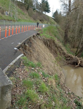
Erosion of the soil beneath a 55-foot section of the Springwater multi-use path on the Willamette River just south of downtown Portland has worsened due to weekend rains and now the Portland Parks & Recreation Bureau says closure is a “possibility.”
Last week we shared that the path had been damaged by erosion and Parks had placed cones advising people to steer (and walk) clear of the edge. Apparently the plentiful weekend rains have taken a toll. This morning we received tips from two readers that the damage had worsened.
Brent L. rode past the area highlighted in our post (which is about one mile south of SE Ivon where the path begins) and says he noticed, “substantially more of the bank had fallen into the river.”
Another reader, Rob W., called in to echo that observation. “A lot has changed [since last week]. I think the whole bike path and maybe the railroad is in trouble.”
Here are a few more photos taken April 2nd at around 6:00 pm by reader Rob Walton:
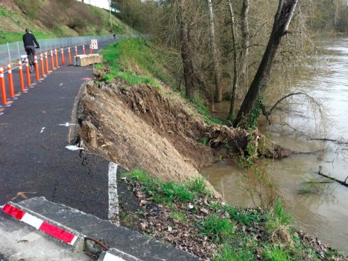
Reached about the erosion today, Parks spokesperson Mark Ross said, “PP&R is aware of the further erosion. We are working closely with a geotechnical engineer, and she tells us the trail is still safe for users at this time. We continue to monitor it daily for any changes that would warrant a complete trail closure, which is a possibility. Concurrently, the engineer is designing a fix for the failure.”
This stretch of the Springwater is a crucial link in the bike network as it carries traffic between the Sellwood neighborhood and downtown Portland. We’ll keep you posted if a closure occurs.


I really hope it stays open, otherwise I’m stuck taking the bus to work.
The river is almost at flood stage right now and the bend in the river at that spot means a lot of the river’s energy is focused on undermining that bank.
If the bank in this location had been structurally reinforced last year when the first signs of slope failure became obvious, instead of just covering the damage with plastic, the current situation might have been avoidable.
It’s going to be a much more costly fix now, and it may not be feasible to do any work on the bank here until low water stage returns in July sometime; at least some of the work will probably need to be done from the river, rather than from the trail.
Or the river might have undermined the reinforcement and caused the damage anyway. It’s pure speculation to say what may have happened if the city had chosen “response X” instead of leaving it be. The trail alignment and railroad lie within the flood zone of the river, on river sediment which is prone to shift. It’s the same conditions that are pulling apart the Sellwood bridge.
This is exactly why we need a resilient, multi-approach bike infrastructure in the city. There are alternatives to the Spingwater, but they’re not comfortable for everyone.
actually, a certain amount of the rail line and trail are built on fill, and the geotechnical engineering involved isn’t rocket science.
I stand by my assertion that delays in repairing the damage earlier has led to the current conditions and it will now be much more costly and difficult to fix.
Is there anything you don’t complain about? Perhaps you should run for mayor, since you apparently have all the answers.
This is why Portland can’t have nice things. Someone has an intelligent thought on a subject, and gets shot down.
furthermore, I believe that the west end of the Sellwood Bridge is situated on a landslide, and the soil mechanics involved in the two failures couldn’t be more different.
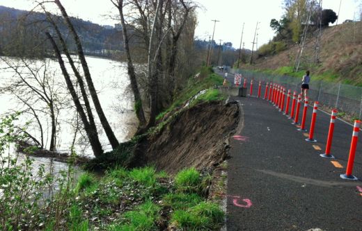
Compare the photo by Chad Berkley accompanying the March 29th story with his photo of today. In the 3-4 day time span those photos cover, a large amount of earth has fallen away, and the angle of the bank remaining is sheer.
Seems like it would take a huge amount of fill to sufficiently change that angle. Maybe pilings is what the engineers will conclude must be used to stabilize the bank.
Bet if this were a similarly traveled road open to motorists, this would have been fixed already. This is why PBOT should be handling critical transportation connections, not PP&R.
I rode this segment yesterday and the damage is far, far worse than shown in this picture.
If I recall correctly, the Springwater Willamette trail is scheduled to be closed south of the connection with the Oaks Bottom trail this summer while the City alters the way water flows between the River and the Oaks Bottom wetland. If repair of this section of the trail is needed, perhaps it can be coordinated with the other work, so we don’t have two closures this year.
Fortunately the damage will get more attention, given the railroad presence, than it would if it was “only” a bike path.
One in-bound alternative to the bike path is Bybee, 28th, 26th, Clinton and then through Ladd’s to the Hawthorne Bridge. Maybe a little longer depending on your origination, but relatively easy to ride compared to many routes. If someone has trouble handling this route, than I’m not sure how they get to the start of the bike path without feeling uncomfortable – unless they live right next to it.
I was thinking the same thing with regards to the rail line. You can bet they’ll help with a more expeditiously scheduled repair. I hope anyway.
“a crucial link in the bike network as it carries traffic between Sellwood and Portland.”
Breaking news, 1893 Edition: Sellwood Annexed to Portland!
I rode by this segment yesterday. The damage was far, far worse than shown in this photo. I wouldn’t be surprised if the closure comes this week.
the crack in the soil in the foreground of the photo looks indicative of additional incipient failure to me.
it will affect my commute when the path is closed. But I already have alternate routes, not ideally but workable.
Hey o/o,
In the event of a closure, I’m collecting all the info about alternate routes for a follow-up post. Can you please share your route with us?
If it is closed, I hope it will highlight the very non-bike-friendly avenues that flow between Brooklyn and Westmoreland/Sellwood. Riding on 17th or Milwaukie is not ideal and can be very dangerous. There is a complete lack of facilities that will get you across 99E between Brooklyn and Westmoreland. Once you get to Brooklyn going north or into Westmoreland going south, there are other, safer routes, but the section of Milwaukie and 17th between Harold until after Holgate are sketchy with lots of commuters driving too fast on small streets to avoid 99E.
I believe a neighborhood greenway treatment is in the works right now, mainly because of the planned closure of the Springwater this summer (I just got the public notice). Maybe PBOT could move the date of completion of this greenway up if the trail must be closed due to the erosion concerns.
What’s wrong with 17th? The speed bumps from Milwaukie to 99e keep traffic relatively mild the whole way through there, and you don’t generally see much traffic from 99e to Powell either.
Of course its going to slide, its a freakin dirt clif. what is suposed to hold it in place?
dirt+water+mud. mud is a liquid, you can’t build on it without peirs going down to solid ground. I don’t think that is going to happen.
An easy get-around is to turn left at Division just before Ross Island Cement Co., right on SE 9th over the Powell & SE 9th pedestrain overpass, South on 9th and then to Milwaukee to the Holgate trailhead and back down to the corridor. Not too much traffic.
they’ll just put down some rip-rap and some fill and move the “problem” further downstream. this is cheap and easy to fix.
Exactly. This.
Woah. That looks crazy. I hope they can come up with a cheap, safe fix for it. The closure of the Springwater Trail would not be small fry. It might not seem like an important connection, but for many bicyclists, it IS their equivalent of I-5 or I-84. A crucial connection.
I hope any fix will also include the planting of suitable trees on the bank to help stabilize it. It looks like the section that collapsed was devoid of vertical vegetation (?).
make a small prefab bridge structure like what they have near OMSI, truck it in and set it there. A large enough span to allow the bank to continue to erode beneath it. Fix from a floating barge or something, mid summer.
I commute this stretch daily from the Cully to Sellwood. I have an alternate route that is shorter, but the river-route is by far more enjoyable/scenic/interesting. Will be bummed to miss that, but it won’t keep me off the bike.
I have no comment other than to say how impressed I am by the forces of nature. Looking at water levels, I wonder how soon until the river breeches the lagoon of Ross Island; might take pressure off this bend in the river.
Hey CharlieB,
In the event of a closure, I’m collecting all the info about alternate routes for a follow-up post. Can you please share your route with us?
I’ll be happy to add the updated route to OSM in the inevitable event this will close.
Good to see updated pictures. This is my commute route, and I looked at it closely last night. Another 15 feet of bank is slumping at the south end of this slide, and with more rain this week, it may slide into the river.
If the “fix” involves work in the river, it may not come until July 1 at the earliest, due to the Oregon Department of Fish and Wildlife’s guidelines for “in water work” in this stretch of the Willamette (July 1 to Oct. 31, and December 1 to January 31).
Dear Mulder, Skully is in danger again.
It’s our understanding that the culvert project has been postponed until next year so the trail should not be closed due to that project this summer.
Thanks, Brian. You are correct — the Bureau of Environmental Services currently shows the culvert project scheduled for construction in Summer 2013. I thought it had already been delayed once (from 2011 to 2012). I appreciate the update.
And why the BTA should not be emphasizing grade separated MUPs.
I think that’s putting the horse before the cart. Separated, limited access MUPs are the freeways of the bicycle system. Appropriate cycleway treatments, like separate sidewalks and sensors to trigger preemptive greens would help.
Now, if you said “this is why Parks & Rec shouldn’t be in the transportation business,” you’d have nailed it.
Bout time for council to slash Park’s budget, don’t you think?..say 4 or 6 or better yet, make it an even 8% cut. Lets also cut Bureau of Maintenance staff by 30%. Yes, those cuts oughta help Parks fix their little trail thingy, and those culverts in FP that are washing out Leif Erickson as we speak…yes indeed, lets slash their budget but lets also hold them responsible for keeping our public Parks in order. Yea baby. But FIRST, lets make them jump through a 2 year environmental review so we can also preserve those vital NOAA, USFW, CoE and DSL permit review jobs. Lay down some more plastic in the mean time. Oh! Instead, lets take a few million from the general fund and direct the PB to protect downtown Parks (at any cost) from the occupation and anyone that “apparently” lacks a “real” job or wears a hoody. For the love of …err -ahem “gods”, can we please fast forward to November and get this freaking gong show over with.