A Federal Highway Administration grant is allowing the Oregon Department of Transportation to get started on a new path for walking and bicycling in the Columbia River Gorge.
Work began earlier this month on a new, 1.6-mile section of the Historic Columbia River Highway State Trail between John B. Yeon State Park and Moffett Creek. When complete, ODOT says the trail will allow people on bicycles to travel on “a scenic path” between Troutdale and Cascade Locks without using the shoulder of I-84. I
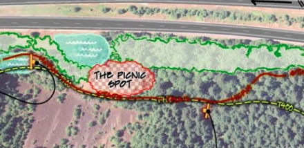
The new path will also incorporate a picnic and rest area with restored views of Beacon Rock and will connect U.S. Forest Service Trail 400 with the Elowah Falls hiking trail.
The $2.1 million project is part of $19.5 million in FHWA grants awarded to Oregon by the FHWA last August.
The grant came from the FHWA’s “Public Lands Highways Discretionary Program” which was established by Congress in 1930 with the intent to, “improve access to and within the Federal lands of the nation.”
The program, which has been a part of every transportation bill since, would no longer exist if the House Republicans are able to pass their transportation bill (H.R. 7). The PLHD Program, along with many others like Safe Routes to School, would be eliminated as a way to “consolidate” and focus Highway Trust Fund spending solely to the Interstate Highway System and bridge projects.
This new section of trail will be completed in early fall of 2013.


Someday I’d love to try that out myself.
One word: Yay!
So is this part of the “long term” rehab of those old, closed-off sections of the historic highway, returning them to use for walkers and cyclists, or a completely new trail?
Sorry, I’m just not exactly clear how this all connects to the existing roads out there! The furthest I’ve ever gone before turning around is Multnomah Falls.
Some of the new path reuses the old historic highway alignment. Some of the old highway was abandoned when US 30 was built during the 1940s, then expanded into I-84 in the late 50s/early 60s. If you continue riding beyond Multnomah Falls, turning right onto the frontage road just past Ainsworth State park, you’ll eventually wind up at Yeon State Park where you’ll be forced onto I-84 if you wish to continue eastward. The I-84 bridge over McCord Creek was the old right-of-way for US 30 prior to the Interstate being built. So a new bike/ped bridge and connecting section of trail needed to be built in this section.
Ah perfect, thanks for the explanation!
Nice, maybe I’ll finally try riding to Cascade Locks this summer. Thanks ODOT!
Ted Buehler
Even better…try to make it back. For a fun loop, go over the Bridge of the Gods and take WA-14 back. If you’ve got the legs, take a detour to Stevenson’s Walking Man Brewing for carbohydrate refueling before the trip back. If you’re worried about the traffic, it’s no worse than battling your way across the city by bike.
should be finished just about the time the Scenic Highway is closed for roadwork. Darn.
Thanks for covering this Johnathan!
Another thing worth mentioning is that this “trail” will be 12 feet wide and paved. Like a Springwater Cooridor through the Gorge.
This 1.6 mile section will close the missing link between the drivable Historic Highway, and 4.5 miles of Historic Highway Trail that has already been (re)built between Moffett Creek (near Bonneville) and Cascade Locks. Very exciting!