
County bike map.
Washington County has a new bike map, and it’s a must-have for anyone with plans to enjoy the fantastic rural roads, trails, and towns west of Portland.
I used the map extensively on a recent trip out to Stub Stewart State Park and Vernonia and it was key in helping me find a low-traffic route on bucolic farm roads north of Hillsboro. The best part is that the map is free thanks to the Washington County Visitors Association.
The map itself is printed on tear and water-resistant paper. It shows roads as far east as the Tillamook State Forest, south to Newberg, and north to just below Vernonia. Campsites, wineries, transit centers (MAX is your gateway to bike adventure) farm stands, bike shops, museums and other places of interest are labeled. And, like any bike map worth the paper its printed on, the new map features color-coded roads so you know what you’re getting into.
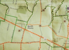
As an added bonus, there are also four featured loop rides, complete with their own inset maps, elevation profiles, GPS coordinates, and descriptions.
Washington County says the map has proved so popular, they had to enter into a second print run just one month after it was published back in May.
You can download PDFs of the map here (front) and here (back).
Learn how to get your free copy of the map on the Washington County Visitor’s Association website.


")
Cool. I’ll have to get one of these. I’ve been thinking of trying to get out to the Banks-Vernonia trail before summer’s over.
Just a note, I think in your 1st paragraph, you mean West and not East of Portland. — Thanks DrSomething. I fixed that typo – JM
The Banks Vernonia Trail also appears on OpenCycleMap as State Cycleway 47.
Cool – just called the nice lady and they are mailing me one tomorrow!
Nice. I do wish that maps like this and the metro Bike There! map were also fully available online in pdf or similar format.
+1
Has WashCo not embraced the computer age yet? Isn’t Intel out there?
Yeah a PDF or Google Maps overlay would be nice…
It might be worth it for Jonathan to put these links in the article:
Front:
http://www.visitwashingtoncountyoregon.com/uploadedFiles/Article/WaCoBikeMap2.pdf
Back:
http://www.visitwashingtoncountyoregon.com/uploadedFiles/Article/WaCoBikeMap1.pdf
I’d like to add that besides the front and back available for download (which can be unwieldy and expensive to print), the individual inset maps are available for download as 2-page pdfs which can be printed on a regular sheet of paper. I’m glad you like the map. I’m the cartographer! Thanks
I’m going to email the cartographer and ask if they’re opposed to me importing their map to OpenStreetMap/OpenCycleMap. TriMet might have already done this based on their own data, but I have’t done any comparisons between this map and OSM yet.
Actually, they are available online through the WCVA. http://www.visitwashingtoncountyoregon.com/bikemap/ It’s rather impractical to download the entire map since it would be so costly to print yourself, but we also have the individual insets available for download which are formatted to be printed on a regular sheet of paper. I’m the cartographer, by the way, and thank you for the positive feedback!
In addition to low traffic routes, I’d like to learn of any low redneck routes. I was almost to the Banks-Vernonia trail last weekend and was just sitting on my bike, twenty feet off the road getting a drink when some jerk in a pickup yelled a, er, politically incorrect name at me and told me to “go back to Portland!” Then peeled out. Later on, another guy ran a stop sign just ahead of me and floored it in a show of Jim-Bob testosterone. A friend of mine won’t even go out there any more due to an extremely dangerous incident he encountered with some teenage funsters in another pickup. Good times! Too bad, because it’s a beautiful trail and a beautiful ride. If anyone knows the low redneck route please post. It may be best to just drive to the parking area at the start of the trail and go from there.
I just called for my copy, and the nice woman who answered the phone knew what I wanted before I asked. She was wondering why the map was so popular all of a sudden today, so I told her about this site. It was a fun conversation, and I’m looking forward to receiving my map.
Also related – Wilsonville has a new Bike and Walk Map available for free at Wilsonville City Hall, Library, Visitor’s Center, Community Center, Bicycle Service Direct, and a few other local businesses in town. The map is also available for pdf download online at http://www.ridesmart.com/Index.aspx?page=200. For more info, contact walkandbike@ridesmart.com
That’s pretty awesome! Can’t wait to pick up a copy, we’re always on the look-out for new places to ride!
Thanks for posting this. This maps is such a great resource. Here’s a link for a pdf of the map: http://www.visitwashingtoncountyoregon.com/bikemap/
The full press release includes a link where the maps are available in pdf form
http://www.visitwashingtoncountyoregon.com/BikeMap/
@A.K. The .pdf files can be quite large and burn up a lot of server resources for downloads. Denver’s is online and takes quite a long time on a slow connection. @PorterStout – interesting – someone yelled the same thing at me from a house near Roy one day. I am out that way at least monthly year-around, weather permitting, and that is almost the only adverse experience I have had, and it was easy to ignore.
There are some brilliant rides out there.
This is a picture from this April.
http://www.flickr.com/photos/kevinwagoner/5626052786/in/set-72157625705553421
The earlier edition of the map had land form coloration, which I liked. This map has more street names, and is easier to read.
PorterStout’s encounter with rednecks is unfortunate, especially considering sub-intelligent members of that species probably aren’t from, or anywhere near Vernonia. Sounds more like the kind of drunk yahoos that drive into the country from some college to generally wreak havoc…shoot up every public sign in sight, throw their trash everywhere, out the window of the vehicle…burning cigarettes, bottles, cans, bash mailboxes … .
I’m glad they’re not quite encouraging folks to take Unger Rd. on the Jackson Bottom Wetlands loop. Somebody’s going to get themselves killed going down that hill.
got mine! 27 wineries and 13 bike shops!