Mapnificent is a new online mapping tool that shows you where you can travel via public transit within a given time from any destination. It was developed in Germany by Stefan Wehrmeyer and seems like it’d be an excellent resource for anyone who is a frequent bus or light rail user.
Simply drop the pin at your origin, type in your destination, slide the time scale (the default is 15 minutes) and voila, you get an idea of where you can travel within that time-frame.
I dropped the pin near my home address in North Portland and here’s what the map returned for a 15 minute time-frame…
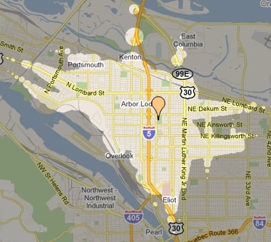
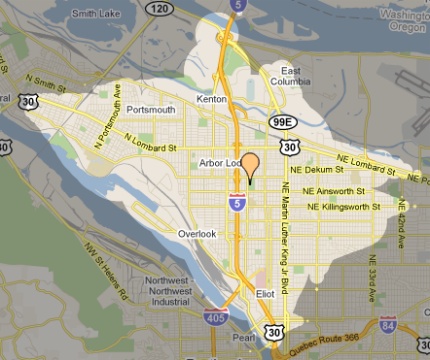
The tool doesn’t offer an option for bike-only trips, but there is a setting that asks, “Do you have a bike with you?” When I ticked that box, here’s how the map expanded…
I don’t use transit much because it costs too much and I have more range and flexibility on my bike (not to mention it’s a lot more fun!); but for those who do use transit, or for advocates looking to make the case for transit, this is a very nifty tool.
I’d love to see this with a “bike-only” option! In most cities, the range of a bike at average speeds (U.S., not Dutch) would surprise a lot of people.
For more on Mapnificent, check out this video and a blog post by Mr. Wehrmeyer.
For more on low-car living check out PortlandAfoot.
[H/T to Gabriel Amadeus and others on Twitter for sharing the link.]
")
")


Very nice. These are exactly the kinds of tools we all need to motivate more people to leave the car at home a few times a week.
public transit scheduling – one of the coolest things the web in its current guise makes possible. Thanks, Jonathan!
I think all your readers are trying to log on to that system right now and it’s overloaded. The travails of being cutting edge….
This is so cool! I am continuously impressed by the creative web/phone apps developers come up with to share transit, walking and biking information. Will definitely share with our commuters.
Does it count the 15 minutes you’ve got to wait for the bus to show up? 😉
Doesn’t appear to. Walking time looks to be included.
+1
Thanks for the link, Jonathan!
I’m not actually a huge fan of this tool — there’s a mini-review behind the page Jonathan linked to (3rd bullet point).
I think it’s pretty clear from the maps linked above that the travel times are way too optimistic. The reason is that Mapnificent’s methodology greatly underestimates transfer times for low-frequency bus lines, and doesn’t include walking time at all. Here’s a similar tool by the Walkscore folks that’s clunkier to use but much more accurate about travel times.
With no disrespect intended for Jonathan or the Mapnificent team, I think one reason Mapnificent has gotten a lot of press lately (besides its amazing user interface) is that its maps look impressive to folks who don’t ride public transit too often. That said, hopefully Mapnificent will improve its methodology as it grows.
Also, I love Jonathan’s Twitter idea of a similar map for biking times.
Sorry, correction: Mapnificent does build walking times into transfers, though it doesn’t let you adjust walking speed.
I was *this close* to writing about this too, but thought it looked a bit like a funky monkey.
I hear you Marshall. And for the type of coverage you do, that’s a greater consideration. I wouldn’t have gone front page if not for the editorial value of the cool map graphics and how “add a bike” was included.
Oh, I’m all for starting conversations about this stuff! It’s also possible that Mapnificent makes more sense in a legendarily good transit city like Berlin, where I think its creator lives.
“I’d love to see this with a “bike-only” option! In most cities, the range of a bike at average speeds (U.S., not Dutch) would surprise a lot of people.”
+1! It would seem that Google Maps already provides some of this information since you can plan your trip by car/transit/bike/walk. However, it tells me that it would take me 8 minutes to drive downtown and 16 minutes to bike there. In fact, the opposite is true.
First time I’ve seen I-84 called “Quebec Route 366”.
It’s a weird error that seems to have appeared 2-3 weeks ago. Apparently a lot of roads are showing up with that label:
http://mapoftheweek.blogspot.com/2011/06/quebecs-longest-highway.html
Actually, I think that’s US 30 that Google is calling Quebec Route 366 – I noticed it last week when I checked out a route to Sauvie Island.
It appears we’ve been quietly annexed by La Belle Province. La Route Verte comes to Oregon!
You’re right. I first saw it in the Banfield 84/30 section. The parts of 30 in industrial NW all the way up to Rainier are labeled correctly, then it switches back to being the Quebec Route. Google/Quebecois shenanigans!
The tool appears to confirm our opinion about transit service. It produces a small circle around our address, apparently confirming that there is no service within 15 minute walking distance of where we live. When we moved in 25 years ago, the bus ran up Cornell Rd with a stop three blocks from the house. Six months later the service was cancelled, never to return.
We are NOT TriMet fans. The fact that our recumbent bikes are not accommodated on transit does not help.