*Portland Parks & Recreation has decided to temporarily close the section of the Esplanade near the ramps and floating docks. Scroll to end of story for the latest.*
Last week we shared a report and photos of how high water on the Willamette River is impacting the floating portion of the Eastbank Esplanade.
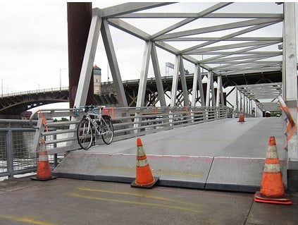
Now, one of the planners who helped design the floating portion of the Esplanade says the ramps will have to be closed if the river continues to rise. Also, many readers are reporting that the ramps — which usually go down to the floating portion of the path — are at a severe incline and pose a serious safety hazard.
On Friday, former City of Portland Parks & Recreation planner George Hudson, said if the river rises just three more feet, the ramps will have to be closed. Hudson, who now works for Alta Planning + Design, says the ramps were made to articulate with changing water levels, but that, “If it [the river] goes up another three feet, they will need to close it down.”
Besides the statewide average snowpack being 127% above normal, warming temperatures, and continued rainfall, Hudson says high water on the Columbia River (which is at flood stages) is “backing up the Willamette like a lake.”
Hudson says a three feet rise in the river isn’t likely, but the water level has definitely risen since Thursday. The entrance to the ramps now has a severe upward incline and the City has spray-painted warning stripes on the ground as advanced warning.
As of this morning, the Esplanade remains open; but people riding on the ramps say more signage is needed to avoid crashes.
North Portland resident Danny Knudsen rode the ramps on Sunday. “They’re almost at a 90 degree angle,” he said, “you have to stop and carry your bike up… There’s no warning and it’s so dangerous I’m surprised someone hasn’t been hurt.”
A commenter who rode the ramps yesterday said, “I wasn’t prepared for the bump at the south end at all — my u-lock popped right out of its bracket at the sudden impact.”
Jonathan Gordon wrote in to says “steep uphill slant” to the ramps is “quite jarring if you’re not expecting it.”
Reader Shane F. just wrote in a few minutes ago saying he saw, “A guy wipe out there yesterday in a really bad way!”
Another reader, Sue K., writes; “Be careful on the ramps to and from the dock on the Eastside Esplanade. You have to stop and pick up your bike! It’s really, really high.”
We’ve been trying to get a comment from Portland Parks & Recreation but have not heard back. We’ll update this post when we do.
UPDATE, 10:10 am: A spokesperson for Portland Parks & Recreation says they are on the scene now and have coned off the ramps. They are making an evaluation and are considering a full closure.
UPDATE, 10:37 am:
For Immediate Release
Contact:
Mark Ross, Public Information Officer
503.823.5300; cell 503.823.6634High Water Forces Temporary Closure of Eastside Floating Walkway
(Portland, OR) –
Rising water in the Willamette River has forced Portland Parks & Recreation to close the gangway and floating dock on the Vera Katz Eastbank Esplanade.A team of PP&R operations supervisors and engineers on-site has determined that the area from north of the Morrison Bridge to South of the Steel bridge shall be closed to all traffic (bike, foot, boats) effective immediately. The area affected is approximately 1000-to-1500 feet of floating territory that the rising water has made impassable.
The closure is estimated to remain in effect for about a week; possibly a week and a half or longer pending conditions and further evaluation. Portland Parks & Recreation’s primary concern is for the safety of everyone using the area, and will keep the floating platform closed until the water subsides. High water may be exacerbated by the recent rains, and hot weather could accelerate snowmelt, further prolonging high water conditions.
Bikers, runners and walkers may access the path along the river via detours currently being set up by qualified PP&R staff. Fencing and signage will clearly indicate the detour paths. Users may cross the river to the west side via the Steel & Hawthorne bridges to circumvent the affected area. We urge all riders, walkers and runners to heed this closure carefully and follow only marked signs and routes.
This marks the first time in the dock’s history that rising water has forced such a closure. Terri Davis, PP&R’s West Services Zone manager, says water has not been at this high a level since the floods of 1996. The Esplanade was built after that time. More info on the Esplanade is below.


")

I seriously doubt the ramps are at a 90 degree angle.
You seriously should go and check them out.
Well I took the pic and I stated that it is at 60 deg on the southtside and on the North end it is almost at 90 … so think about that when someone is ridding this at night and can not see any warrings….
Yep, I took a jump and endoed riding yesterday night. Glad the cones were there so I at least thought to slow down first. Bike was OK!
Only the initial foot-long lip is almost 90 degrees, although the story implies the entire ramp is 90 degrees. That would be kind of silly. Kind of like the Burnside Bridge when it is raised for a ship.
A line of cones is definitely necessary, but not a closure. Give me a break. What about the pedestrians who can easily walk over the step?
i noticed that ramps were quite steep last saturday. I managed to bike over them. There are some standing water along the river by the Corridor from Oaks Park to Ross Island bridge. Oak Bottom is high also. The corridor itself is high and dry.
My wife wiped out on these yesterday and got some serious road rash. The river is not at flood stage, and the walkway should be designed under the assumption that the water will be this high occasionally.
Finally, some decent mountain biking in Portland…
Thank you. Made me laugh.
I wonder if PPS has some ‘stop, walk bikes’ signs that they could put out
Being a bike commuter… I really wonder how many of us would listed to a sign that said “stop” 😉
This is really bad. When I rode over the South end this morning someone was laid out on the ground with a group of people around. Even though I saw the crowd and the orange cones I was not expecting the angle and almost bit it. Extremely dangerous and someone is going to git hurt. The North end is even worse, and yes it’s 90 degrees. In fact the ramp is hanging in the air with a 6 inch gap to the ground underneath. No way to pass without getting off your bike and climbing up and very poorly marked. This should definitely be closed-
They ARE at nearly a 90 degree angle. I saw it myself.
Parks just announced a temporary closure to all traffic…
Contact:
Mark Ross, Public Information Officer
503.823.5300; cell 503.823.6634
High Water Forces Temporary Closure of Eastside Floating Walkway
(Portland, OR) –
Rising water in the Willamette River has forced Portland Parks & Recreation to close the gangway and floating dock on the Vera Katz Eastbank Esplanade.
A team of PP&R operations supervisors and engineers on-site has determined that the area from north of the Morrison Bridge to South of the Steel bridge shall be closed to all traffic (bike, foot, boats) effective immediately. The area affected is approximately 1000-to-1500 feet of floating territory that the rising water has made impassable.
The closure is estimated to remain in effect for about a week; possibly a week and a half or longer pending conditions and further evaluation. Portland Parks & Recreation’s primary concern is for the safety of everyone using the area, and will keep the floating platform closed until the water subsides. High water may be exacerbated by the recent rains, and hot weather could accelerate snowmelt, further prolonging high water conditions.
Bikers, runners and walkers may access the path along the river via detours currently being set up by qualified PP&R staff. Fencing and signage will clearly indicate the detour paths. Users may cross the river to the west side via the Steel & Hawthorne bridges to circumvent the affected area. We urge all riders, walkers and runners to heed this closure carefully and follow only marked signs and routes.
This marks the first time in the dock’s history that rising water has forced such a closure. Terri Davis, PP&R’s West Services Zone manager, says water has not been at this high a level since the floods of 1996. The Esplanade was built after that time. More info on the Esplanade is below.
Wait, it’s closed, really? I rode over it just 3 hours ago…there were some green utility vehicles and a guy taking photos of the ramp. Now I feel like a jerk, but no one really stopped me and I didn’t see any closure signs. Maybe as mentioned in the previous comments, they were just about to install the fences.
And yes, it’s freakin’ steep. On a track bike with 23c tires, even approaching very slowly, it HURT. I was almost worried that I’d break a spoke or something. Closing it temporarily is probably for the better.
Yes, they are very dangerous. I saw someone crash there yesterday. Although it would be inconvenient, I think they should close them before someone cracks their head.
Huh, I’d love to see more pictures of both sides submitted by readers if Jonathan would be willing to post them above.
I thought about going down just to look yesterday, but I didn’t want to deal with the holiday crowds.
sounds like the water has rised some more last time I went.
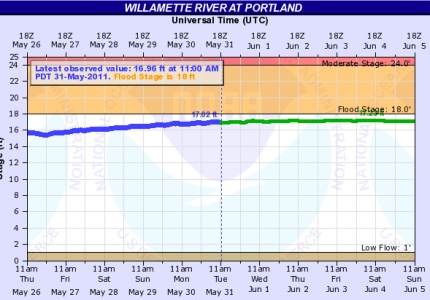
Here is a graph showing the current water levels. Its a foot below flood stage. 1996 reached 28.6 ft, over 10 feet higher than now, which is really an amazing amount of water.
http://water.weather.gov/ahps2/hydrograph.php?wfo=pqr&gage=prto3&view=1,1,1,1,1,1,1,1%22
Perhaps PP&R could liaise with PBOT and PPB to set up OFFICIAL detour signage for a temporary surface street re-route for cycle traffic during this high water event.
At the very least auto drivers need to be warned of the modified and seemingly random traffic patterns of cyclists as they attempt to divert from a popular route.
I walked over this yesterday, and witnessed a lot of folks on bikes struggling when both entering and exiting the ramp. It was very steep – deceptively so; it was hard to tell just how steep it was until you were right on it. A lot of people were getting off their bikes while going up it, and then nearly crashing while going down it. I was especially concerned for the parents with kids on trailers, and the tandem bikes.
Just ran this at lunch (~11:45) and didn’t see anything besides the warning cones.
yes, yes, it was very deceptive on the approach to realize just how steep that ramp was. I took a picture this morning with my bike to show perspective (http://farm4.static.flickr.com/3417/5783180364_9432016bed.jpg).
Simple case of bad design.
Or perhaps a trade-off between cost and a more expensive design. I would not presume either. I know the City spent a lot of time thinking about high water events when designing the East Bank Esplanade shortly after the 1996 Flood. The City got a fair amount of criticism for the design costs at the time. In the big picture, I think they did a pretty darn good job.
Saw this yesterday and recorded people on my flip cam approaching… no accidents but alot of close calls, for me personally though it was fun cause i could approach high speed and bunny hop onto them! The footage that i got though shows time of it wavering 60 to 90 degrees and one wave that lifted it to it’s max! Crazy stuff!
Blake – yeah, The Jetboat went by as I was walking on the floating bridge, and the wake from that caused a significant amount of wavering.
What people need to realize is the reason the Esplanade is floating so high is not because of the Willamette River…but the Columbia River backing up into the Portland Harbor. While the Willamette maybe no where near flood stage, it is the Columbia that is a foot over the flood stage….go check it out…kind of cool to see. And Remember, it was 63 years ago yesterday that the historic Vanport flood happened.
This could easily be fixed by making that hanging transition lip a lot longer.
This just highlights the need for a good eastside (direct and fast) North-South bike route between Hawthorne and Broadway which is not the Eastbank Esplande. Eastbank esplande already too choked with joggers, walkers and others to be a safe and effective cycle commute path during peak summer use. Anyone else see the arguments breaking out there daily between cyclists and other users over speed and safety?
Wait — pedestrians aren’t entitled to walk 7-across on the esplanade? Having ridden it every day for ten years, I thought for sure I missed the memo on that!
There are plenty of North-South routes already available:
-SE 7th Ave, which has bike lanes. This hooks up with NE 12th.
-SE 16th Ave
-20th/21st Ave
-SE 26th/27th Ave
-SE 41st
Yes, I agree we need more north-south routes on the East side. I went on an errand at lunch today on the east side and had a really hard time finding an alternate route, knowing this path was closed.
Depending on how far you need to go on the Eastbank, I’ve found a good alternative to the waterfront is to take SE 3rd through the industrial area, and then bike over the Burnside bridge. You can get onto and off of the bridge into/out of the Industrial District very easily.
I take it all the way to/from SE division, and find it far more pleasant ride without all the joggers/walkers/strollers/dogs/other cyclists, even with having to stop at a few stop signs. 🙂
You can step up and down the ramps (I saw a rider ride up one!) but if the water gets any higher it will be a very large step.
16th from Irving to Ladd’s Addition is a good alternative.
they were installing big fence gates on each side of the floating ramp about half an hour ago, it may already be shut down. that incline is STEEP, don’t be lazy, get off bike and walk it
I flipped and landed on my head and shoulder when I hit the lip on the floating dock this morning. My helmet cracked, but no concussion and no broken bones. Saw the cones and slowed down, but I was sort of in lah-lah land and just assumed it was somebody doing work ahead, rather than a serious obstacle, so I was unable to come to a complete stop
Time to remove the Eastbank Freeway and replace it with a human scale boulevard featuring a 50′ wide promenade along our River. Freeways thru cities are toxic rivers and should be replaced with housing and commerce.
I don’t think they will be ripping out I-5 any time soon…
ODOTs plans actually involve expanding it through the rose quarter. I think our best hope is some sort of cut/cover solution once the Marquam bridge reaches the end of it’s life. The east side would be completely transformed if they berried I-5 and replaced the Marquam with a tunnel under the river.
You can’t pay me to cross the bridge. It’s an overloaded structure and I really question if the seismic retrofit really made that bridge any more sound. Until it’s restriped back to it’s original three lane, two shoulder configuration (thus limiting it’s maximum capacity), I’d rather take the Fremont or the Hawthorne Bridge…
Seems like it would make a lot of sense to remove I5 between the south end of 405 and I84, and renumber the segment between 84 and the Fremont Bridge as 84, and sell the Marquam Bridge for scrap.
Wow, I road over it last week and was impressed, but that picture shows me that it raised even more. I don’t need a sign to tell me my bike might not like popping over that bump.
Just another reason to pay attention and work on those bike handling skills.
Not to nitpick, but it’s a floating bridge and a floating pier. The dock is the space of water between piers.
I appreciate Parks & Rec keeping the bridge open as long as possible. It truly is the backbone of our bike network in this area of the city. Everyday it’s closed is a big deal for those who walk and bike to get around this city. If this closure is destined for weeks and not days, I hope we will see PBOT stepping up to provide a detour via MLK and through the industrial district.
Sheesh, this is nanny-stateism at its worst. CLOSING the path because of this? Just put up a huge warning sign that can’t be missed, and/or a barrier that forces people to dismount, and let people use the ****** path.
And by the way, this may not occur to many in the “bike community” in this anti-MTB town, but those of us with mountain bike skillz can easily take that ramp. Either direction. On a road bike with 23c tires (though why people commute on race bikes is beyond my comprehension).
Considering the ramps aren’t even touching the landings at this point, there’s not much reason to keep it open. That said, I think we can all agree that a floating bridge isn’t exactly practical for that part of the bike network, and a good example why PBOT and not Parks and Rec should be in charge of the cycleways.
my tires are inflated at 125-150 psi. i have not had a flat tire in 2 years. yes, that is years. is that a good enough answer?
I actually broke my collarbone wiping out there Monday. It was certainly my fault for not taking it slower, but I’ve repeatedly seen cones out for trivialities and this was less marked – a force-dismount barrier would have been/still be appropriate.
I always slow down for these ramps even when they are at a normal angle. They don’t provide a very good transition and it would seem to me that anyone who gave a rat’s behind about their rims would slow down anyway. I even try to jump up in my toe clips so my weight isn’t on the saddle when I hit them. All the city needed to do was put up a maze of barricades that would have forced people to slow down. They didn’t need to shut the whole thing down. Typical politically correct overkill
BTW, I based my earlier comment on the picture shown above. If as Paul Johnson says above, there’s now a vertical gap, then I take back what I said and they should shut it down.
Couldn’t agree more
I called Mark Ross today at Parks and Recs and he informed me the floating bridges of the Esplanade will continue to be closed for the immediate future.
Not to crazy about putting my life into the hands of others trying to making it through the gauntlet of distracted drivers through what is the downtown/hotel portion of Broadway to get to my downtown location. Today’s close call was a delivery truck’s mirror about 8 inches from my helmet when he passed me, encroaching on the bike lane.
Looking forward to the re-opening bash.