(Photos © J. Maus)
[Publisher’s note: This article was written by contributor Daniel Ronan. He’s a student representative on the Oregon Bicycle and Pedestrian Advisory Committee and covers statewide programs and issues. Read his previous articles here.]
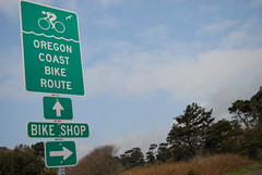
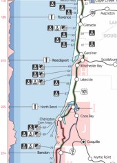
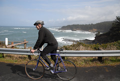
Each year, between 4,000 and 6,000 bicyclists take the Highway 101 route along the Oregon Coast, mostly during the warm summer months. What helps many on their journey is ODOT’s Oregon Coast Bike Map (PDF link) that details the 370 mile route and lists information on traffic volume, weather, elevation, state parks, and other helpful tips.
Last week, Sheila Lyons, the state’s Pedestrian and Bicycle Program Manager, came to the University of Oregon InfoGraphics lab (a part of the Department of Geography) to discuss cartographic design options for the reprinting of the Coast map, which is scheduled to happen next year.
“The Oregon Coast Bike Map is by far ODOT’s most popular bike map, people love this map,” says Lyons.
The meeting with some of the project coordinators, including Ken Kato, Ben Metcalf and Matt Landers, focused on updating the map to better alert riders to the suggested 101 Coast route. Central to the conversation was the question of how to include traffic volume, elevation, and shoulder width statistics in a more effective and easy to read format. Lyons addressed the trade-offs of giving too much information, “We want to give them information, but what we don’t want is a person looking at this map to say, ‘it’s too dangerous.’”
During the discussion, project coordinators held up Metro’s recently debuted Bike There! map as an example of how to use attractive, but appropriate symbology. Project coordinator Ken Kato said, “We’re looking to create a coastal experience,” which brought several head nods around the table.
But that experience remains lacking in certain places along the route where signage is sparse and riders have a hard time avoiding high-traffic roads.
Lyons says many cities have suffered layoffs and budget cuts meaning that there hasn’t been enough money to fund bicycle improvements. But, even with significant funding challenges, there have been success stories. In Newport for example, supportive businesses (like Bike Newport), bicycle coalitions and neighborhood associations helped raise funds for new signage to divert bicycle traffic from a congested section of 101.
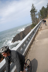
In general, however, signage is relatively low in the project queue. Planning around choke points with necessary improvements remains the largest obstacle. In Newport for example, while local advocates have made progress with signage, the biggest problem is the lack of safe bikeways on the bridge to the south over Yaquina Bay.
While funding for the state’s bicycle network remains a challenge, a bright spot for the Coast Route, says Lyons, is the possible connection with other networks on the horizon like the Oregon Scenic Bikeways and the U.S. Bicycle Route System.
But even on its own and with its shortcomings, the Coast Route remains a popular attraction for bike tourists from Oregon and across the globe.
If you’ve ridden the Coast Route (especially if you used ODOT’s map), what was your experience like? ODOT and the folks at the UO Department of Geography are interested in your feedback. Be sure to leave your comments and suggestions below so we can all have a better “coastal experience.”
— You can find the Oregon Coast Bike Map online (as a PDF), in various visitor centers and bike shops, or by calling the ODOT maps hotline at (503) 986-3556.


The signs are more necessary for motorists than cyclists. Having the signs on 101 reminds drivers that they have to share, and chill out a little. In fact, ODOT should just print all-purpose signs: “This is the most beautiful road in America. What’s your hurry?”
I first did the OR coast about 8 years ago and the map (+ asking around) kept me on track the whole way. This was my first solo tour ever BTW so I was a noob. My only complaint was on a section of the route detoured off 101 south of Coos Bay. The detour was great but described on the map as passing through old-growth woods. Well since the map was printed someone had knocked down those old-growth woods.
And yes, that Yaquina bridge is hair-raising. Even a fence over the railing would help, on a bike on the sidewalk that railing is about saddle height and the whole time I imagined myself pitching over the edge. I was recently in Newport with my family and wouldn’t ride over the bridge with the kiddie trailer. Sidewalk is too narrow for a trailer (and too high for me but that’s my hangup); and too much heavy traffic on 101. So I had to stupidly drive the bike + trailer 1 mile across the bridge just to ride to South Beach SP, Rogue brewery, the aquarium etc.
As I remember it, all the other bridges were no problem.
bikes aren’t allowed on the sidewalks of the Yaquina bridge… that’s why there’s a button to push that makes the “Bikes on Roadway” lights flash while you’re crossing… yeah, the railing is low, even when walking across, so that’s probably why they don’t allow bikes up there since it’d be easy to tip over the side…
that coast map looks awesome, except that it takes you on hwy 101… hehe… you really need to be an expert rider to take that highway… lots of motor homes and boat trailers on a road barely wide enough for two cars… I’m sure there’s plenty of people on this site that have no problem riding with that much close traffic but I don’t like being in the way that much…
I didn’t find taking the road on the Yaquina Bridge to be too bad, but we were riding during off-peak season and off-peak hours. To me, easily the most uncomfortable riding section of the “Oregon” coast is the bridge from Astoria to Washington…just plain scary.
One thing that would be helpful on a map – although it may or may not be desirable from ODOT’s perspective, as it would add labor time and require additional maintenance – would be to make the new ODOT coast route consistent with the other primary coast route resources (the two that come to mind are Bicycling the Pacific Coast and the ACA maps). Virtually EVERYONE on the coast route carries one or more of these three resources, and the suggested routes are probably 80-90% identical. I think it would be helpful to at least show the 10-20% route divergence on the ODOT map, perhaps with a different symbology for “Alternate Route,” with some type of disclaimer.
David #3, RE: Astoria Bridge
Yes, I wish they had though of even limited pedestrian needs when they built that bridge in the 60s, as there isn’t even a sidewalk to make walking across the channel a viable alternative. Granted, it’s 4 miles, but still. A choice would be nice.
They do close one lane of the bridge for a few hours each year so they can do a “fun-run” type event, but the city of Astoria currently has no plans to do the same for cycling, which is a shame.
I use to have the idea of riding from Astoria to the end of the Long Beach peninsula in Washington, but the small shoulders and high speed of large passing vehicles such as RVs has scared me off from attempting that, and I’m a decent cyclist (though I have no touring experience, just PDX city riding).
My first ever bike tour was of the Oregon Coast, and the ODOT map made it a total breeze. I thought they did a great job presenting rather complicated information concisely (route/alternates/mileage/elevation/services/camping).
I highly recommend taking their “alternate route” suggestions, even when 101 looks like a nice straight shot. The Slab Creek Rd. detour just south of Neskowin is has a great descent which ends at this tiny cafe with great milkshakes.
The one thing I never got was how all the Oregon State Parks put their hiker/biker campsites right near park entrances. I wouldn’t mind rolling along another 1/2 mile to the most remote corner of a park. But for $4 a night, I can’t complain…
I rode the Oregon Coast route this past October. This was my first self supported tour. I depended on this map to lead me along. It did a great job for being a free map. My only complaints are that the mile post numbers for the off 101 detour near Winchester Bay are wrong. It would be nice if they added directions or at least details about where the bike shops in town are. You could need a part only a shop would have and pass right by it if it’s not directly on 101. Overall a great map though.
We spent three years taking our clients on tours of the Oregon Coast, with the tour following the route for significant portions. After three years, I made the decision that we’re going to cut this route (even though it was our most popular) due strictly to safety concerns and re-focus our Oregon programs (we operate in Oregon, Hawaii and California) on our other route, which largely follows the Willamette Valley Bikeway. The decision was made purely due to safety considerations — which are a particular concern given that we largely cater to beginner cyclists.
The truth of the matter is this — if the coastal communities want to see more tourism dollars floating their way, they need to invest in world-class infrastructure required to make people feel safe. Between the lack of appropriate cycling infrastructure on many stretches of the highway, and the cultural distaste for cyclists (and thus numerous threats our clients received from drivers) there needs to be some really large shifts to take advantage of the tremendous opportunities that nature has gifted those communities.
While I appreciate the gesture from ODOT to create a nice map, and have used that map numerous times, the reality is that they need to step up and invest in the sort of infrastructure that can fully take advantage of the powerful opportunity for bike-related eco-tourism. There is absolutely no reason why that route cannot become the top destination for cycling in the US, and everyone knows how badly those communities can use the tourist dollars that would bring.
This is a tremendous opportunity to drive economic development in many smaller coastal towns. I know first hand from speaking with some business owners out there how much they appreciated us stopping at their establishments; and it was very sad to have to cut that route because it’s simply fundamentally unsafe. I also cannot help but wonder whether intentionally creating maps that make a route appear safer than it actually is could open ODOT to lawsuits from people who routinely get injured biking that route. I’ve unfortunately heard far too many sad stories.
Yes everyone’s budgets are tight; but that means that the dollars should be spent in ways that are smarter and maximize the ROI (return on investment) for those tax dollars. I know there is a solid case to be made for turning 101 into *the* biking destination in the United States. Making a prettier map is not enough — the infrastructure has got to be built.
Vladislav, could you elaborate on the parts of the Coast Route that you think are unsafe?
Given the heavy traffic, high speeds, and a large number of logging trucks, we consider any section of 101 without a full-size shoulder as inherently unsafe for our clients.
I love this map! I have relied on it when I toured from Tillamook to Reedsport.
It might be worthwhile to check and update the information on state, county, and other parks. I think that some of state parks that are listed as having water do not (or did not, as of Sept. 2009 — if memory serves me well, one park listed as having water which does not is just south of Cape Perpetua). A tourer I met last summer told me that the county parks in one town (I don’t remember which, sorry!) do not exist anymore but are now privately run facilities — but I have not confirmed this personally.
@Spiffy #2 – Yes, the Yaquina Bay Bridge is harrowing — especially with stout cross winds! I was that way in March – I think you are allowed with a bike on the sidewalk, provided you walk your bike; I recall signage to this effect.
I cycled from my home in Vancouver down the coast to Mexico this summer, and this map was a real treat. Without it, I’m sure I would have had no problem getting to California, but this map made it so much more enjoyable. Most of the routing off of US 101 and the other alternates are great, although a little more signage would probably be helpful for those without additional maps. While I had already planned out which campgrounds I was going to stop at, it was nice to have all of the state parks listed, along with their amenities. The most useful part of the map for me had to be the elevation profile, because it’s always nice to know what you’re up against.
I can’t think of many suggestions for the map itself, only physical improvements to the route.
SilkySlim, did you camp at Umpqua Lighthouse? Their hiker/biker camp was secluded off at the end of the park, set in the woods behind all of the other spaces.
I would echo Vladislav. Although many sections of the coast bike route are reasonably safe, there are significant sections with inadequate shoulders.
I generally won’t ride them either. Besides logging trucks, rental RVs (most driven by people with little RV experience and a poor sense of the vehicles’ size) can be a problem in summertime too. After watching my wife nearly get sideswiped and killed by a rental RV while riding around (shoulderless) Crater Lake a few years ago, I take this pretty seriously now.
I’ve been a resident of Newport for 25 years and have been commuting across the Yaquina Bay Bridge for all of them (total mileage would get me across the U.S.). The railing is not so low as to allow a bicyclist to fall over it without extra effort. The concern, which is justified, is riding on the sidewalk where there is little or no room for error. Signs at both ends of the bridge “recommend” that bicyclists walk their bikes. I ride south on the roadway when visibility is clear enough for motorists to see me. The amount of traffic is not and should not be a concern if you ride no closer that 3 feet from the sidewalk/curb. Take the lane and do not give motorists an option to try and pass when there is oncoming traffic. When I ride on the sidewalk I am very aware of how narrow it is and do not take unnecessary chances. If it’s windy I walk the bike. BTW, I am the person responsible for getting the “Bikes on the Bridge” warning lights and lowering the speed limit from 45 to 35 mph. The lower speed limit doesn’t deter some but that and the warning lights have helped raise the level of awareness for motorists. I’m still working on an alternative route for pedestrians and bicyclists. Anyone have any spare change for a new bike/ped bridge?
This is a great map, and a great tour route. I’d like to see more private tenting options indicated, and more information about the connections to towns and cities east of the coast like Portland and Eugene.