The Oregon Department of Transportation has taken a bold step into the 21st century and has published their Oregon State Bike Map online for the first time ever. The map has been available for nearly 15 years, but prior to this week it wasn’t even available as a PDF, much less publicly available on the Internet.
The map is also now GIS based and has up to date data on road conditions. The map is broken up into nine printable sections that can be downloaded from the ODOT website.
ODOT bike and ped program manager Sheila Lyons says the map is a “road map with information for bicyclists.” Instead of recommending particular roads as designated bike routes and labeling them different colors, Lyons says they decided to just provide information someone might use to decide for themselves which roads to ride on. The map labels highways with shoulder width greater than 4-feet and information on traffic volume, terrain, and elevation is also available.
At this time, the state’s official Scenic Bikeways are not on this map, but Lyons says they hope to include them on future versions once that program is more established.
The legend for the map is currently only on Tile #2 and ODOT bike and ped program manager Sheila Lyons says she’s aware of that issue and plans to put the legend up as a separate PDF soon (I also didn’t see the separate download for traffic volume information, so hopefully that gets added soon as well).
This is a great way to assess relative bike-ability of roads when planning your spring and summer adventures. For more detailed roadway information, you’re advised to complement this with city-specific maps.
As always, ODOT would love your comments and review of the map to improve future versions. If you’d rather have a hard copy of the map, you can request one for free by calling (503) 986-3556.


Hooray! It’s about time, as the printed version is over 10 years old. Looking forward to poring over this map in detail and submitting suggestions!
Initial Comments:
The map has clear use of symbology, and the relief shading for topography gives the user an idea of what they are heading into – the 1999 printed map failed on both counts. One feature from the 1999 map which is now absent is the chevrons showing major hills. Also absent are the large shaded arrows denoting prevailing winds, and the road coloring denoting traffic volumes – these would have been good features to keep.
The worst part of this is only putting the map legend on one of the nine maps – there’s no excuse for that, especially when the clickable overview map on the website gives no clue as to which of the nine maps the legend is on.
Also, the map doesn’t show county campgrounds – there are few enough of them that I can’t see why it doesn’t include them. Areas with more than one campground (like the Clackamas RD in the Mount Hood National Forest) do not show all the campgrouds – it would be good if the tent symbol had a little “x2” or “x3” next to it to denote that there are more than 1 camp. Also, for the state parks, it would be useful to deliniate which ones have hiker/biker camps.
Also, the map fails to show the Faraday route route along 224 which allows cyclists to skip a 600′ climb, and there are no close-up inset maps as there are on the 1999 printed map.
The map looks good, and provides some important information, but there’s a LOT of room for improvement. I hope that the state is committed to maintaining and improving it. Thanks for the post, Jonathan, I had no idea they were even working on this.
Oops – one correction. They have an inset map of the Willamette Valley, as in the 1999 printed map, but no insets for Portland, Eugene/Springfield, Salem, Medford or Bend. Bend wasn’t on the 1999 map, but given the explosive growth in the last decade it warrants one now.
The lack of a easy to find legend is problematic – excellent review Matt.
This is pretty, and useful, so thanks to ODOT for that. But there are a couple of important ommissions/errors that I saw off the bat:
1.) I’m 95% sure that the crossing of the White River between OR 216 and NFD 48 near Wamic is not paved.
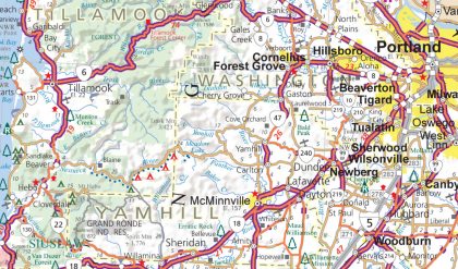
2.) I’m just as sure that you can’t get between Cherry Grove and the Nestucca River road on paved roads without going down to OR 47.
3.) Bible Creek Road between the Nestucca River Road and Willamina actually is paved, but this map shows it as gravel. The Bald Mountain Access Road over Sheridan Peak in the same area is also paved, and this doesn’t show it at all.
4.) Mary’s River Road between Summit and Hoskins is not paved in the middle, and this map shows it as paved.
If I am mistaken about any of these, I would love to be corrected.
You might think, well, who cares about these minor traces, off the beaten path. But as a touring cyclist, I’m looking for the smallest backroads that are still paved — the scenery is better, there is little traffic, and I can still make good time and ride in comfort because it’s a good surface. It is exactly these little out of the way byways that a map like this has to get right to be of the most use.
So, for other similarly minded cyclists, this map is a good place to start, but always verify that the route you want to take is going to be what you expect — a resource like the satellite view (or even better, the street view when it’s available) on Google Maps is very useful.
The map is pretty good. The map being made available online will facilitate the feed back to improve the map.
As a SW Oregon native (Glendale, town of 700 at the time), the logging county between I-5 and the Coast is great hiking and trail riding.
I would recommend the Glendale-Powers route as a great paved and scenic trip for those looking to breath in mountains instead of car fumes.
If someone is willing to brave dirt logging roads and possible Big Foot encounters, the Glendale to Bold Beach (via Galince and Agness) is a great trip.
About ten years ago, when I was on home on leave from the military, I hiked from Gold Beach to Crater lake following (as much as possible) the Rouge River. Now, I am tempted to make the same trip via a bike using the network of logging roads.
Michael,
You just need to get fatter tires.
-RayO
Is it me or is this map totally not helpful?
The scale is not nearly close enough to take in the side roads that cyclists would much prefer. The pdf isn’t much better than a highway map. I don’t get it.
Michael (#5)- i think you’re right on #2 thru 4, or at least you were the last time i rode them. Haven’t ridden #1 past the Barlow Crossing at the White River, but the Forest Service map shows it as paved all the way to Wamic.
I agree with your commentary. I also recognize the difficulty in assembling this type of detailed information for the whole state — well worth doing, imo, but a very big project.
The shaded countour is nice, but I do agree that the chevrons and wind-direction arrows in the previous version were a nice feature and I will miss them.
Unfortunately I have the same problem with this map that I did with the previous version: it only indicates whether or not the shoulder is 4′ wide or not. On a quiet highway, say out in the wide-open deserts of SE Oregon (where there are usually NO shoulders), a 4′ shoulder would be heaven.
But a 4′ shoulder can also be hell. Having once ridden the section of US 97 from Shaniko to Criterion, I’m content to leave that at ONCE. That highway has a 4′ shoulder all right, but when big rigs are blasting by you at 60mph a couple times a minute, a 4′ shoulder is NOT MUCH. I didn’t fear for my life, but it was a distinctly unpleasant experience.
I’d like to know which shoulders are at least 6-8′ wide and (if traffic is heavy) still provide a reasonably enjoyable cycling experience. I’ve seen this on other states’ cycling maps. For that matter, years ago I remember seeing a WA state map (may not have been cycling specific) that had all the highways color coded by traffic volume. Now THAT is nice information for a cyclist to have!
Jeff (bikieboy #10)-
It’d be awesome if that crossing of the White River was paved, but in spite of what your forest service map says, I don’t think it is. Take a look at it with the Google Maps satellite view, especially right near the river — it really looks like a dirt road to me.
If it is paved, then you could get from Mt Hood to Madras via NFD 48, Wamic, Wapinitia, Simnasho, Warm Springs, and Lake Simtustus and see maybe 2 cars all day (except for the short, flat stretch on US 26 between Warm Springs and the turnoff to Pelton Park). Which would be awesome. I should take a bike with 32’s out there and check out the conditions some time!