new Sierra Cascades Bicycle Route.
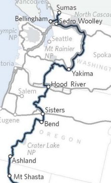
The Adventure Cycling Association will officially launch their new Sierra Cascades Bicycle Route tonight at the REI store in the Pearl District. As I reported back in February, the new route stretches nearly 2,400 miles from Canada to Mexico. It will also give Oregon a nice boost in bike tourism because it rolls through the Columbia River Gorge and Hood River before heading south through Sisters, Bend, and then onto Ashland.
Adventure Cycling’s executive director Jim Sayer says about 250 people showed up to the Sierra Cascades route launch event in Seattle last night.
The event is being held at REI because the national outdoor gear retailer has been a long-time financial supporter of Adventure Cycling.
Here are the details of tonight’s event:
- Sierra Cascades Bicycle Route launch party
Wednesday, April 7th
Refreshments at 7:00 p.m., Presentation at 7:30 p.m.
REI – Pearl District (1405 NW Johnson St)
Eugene readers take note. You can catch the launch at your local REI tomorrow. More details here.


Yay! I used to live in B’ham WA and that’s an optional starting/ending point.
Does the route pass through any towns with an REI?
Todd, there is an REI (with a bike shop) in Bend.
I’m glad REI sponsors stuff like this. And the ACA’s adoption of the route will definitely put it on the touring world’s radar.
I’ve done the Washington leg and it was gorgeous. Gonna do Oregon this summer.
I wonder if Sierra Cascades has retained as an option the original alternate that skips Bend but rides up closer to the Three Sisters? No REI up there. Guess I’ll find out tonight.
Is this an officially signed route with government backing and signage worthy of being mapped for navigation, or another ACA attempt at masturbation?
I mean, it sounds like a good idea, but on the other hand, if it’s just the ACA declaring a cycle route only accessible to ACA members and not something they’re willing to share the data with other agencies, who cares?
Paul: ACA maps are reasonably priced, incredibly thorough and available to anyone. I doubt the route is signed specifically for bicycles, due to expense. I say, the more bike routes, the better, ACA or not.
Paul – ACA routes are just their own designations. What it means it that they’ll develop a series of maps that have extensive, detailed information of the route, elevation profile, services, etc – and those maps are available for sale on their website. You don’t have to be a member to buy them. (though members get discounts)
I bought 2 sections of the Pacific Coast route, and I have to say they are some of the best maps I have ever purchased. (granted, they are only good for the route itself – they show almost nothing off the “official” route) I can’t recommend these maps highly enough within the context which they cover.
Don’t care? Don’t buy the maps. In any case, this news dosn’t harm anyone, or make anything more difficult for anybody, so why the snark? It’s bike-related news, and it’s local, so it’s appropriate.
Why should I buy ACA’s maps of made-up routes when I can use OpenCycleMap.org’s map of REAL, designated routes?
Paul Johnson,
What the hell are you writing about? You have a problem with the ACA? Don’t join & don’t buy their maps. I don’t use their stuff much myself, but I loudly applaud their facilitation of others’ riding dreams.
“Officially signed route with government backing”? “Only accessible to ACA members”??
There is no such thing as a “cycling route only accessible to ACA members.” If you tour or travel on your bicycle, you use existing roads or MUPs – just as ACA maps do. “Other agencies” built the roads & share their data, etc., ACA researches and assembles information and experience and presents it in a package.
There’s still a factor of the maps being closed. That’s a bigger issue, and until they’re willing to share map data with other agencies, I encourage everyone to boycott the ACA and their maps.
(There goes that posting-lag-while-one-responds thing again!)
They’re not an “agency,” Paul.
This smells a little like a copyright issue yer making. So, you maybe think Disneyworld should let you in for free, too, because the city park doesn’t charge admission? Or, maybe a high-zoot restaurant should release all its recipes at no charge to you, because you eat?
ACA’s map sales help support their operations, the maps are a product of their own work, their mission is get people out on bikes across the country, they are a service provider to a segment of the bicycling community. You are welcome to use crowd-sourced data all you want, but nothing makes it any more “REAL.”
I think Paul needs to get out on the open road and blow off some steam!
Sweet moses…
I really want to bike this! Goes through some of the best towns in the Northwest. Just watch for the meth labs in the mountains and carry a lot of mosquito repellant in the summer!
-Ian
Paul,
With the exception of the Open Street Map Project, nearly everyone’s maps are “closed” in whole or in part – I’m not sure why you’re singling out the ACA. Even Google Maps is in part “closed”. Certain datasets are open, nearly all of those are federal or state in nature.
As for why you should use them rather than OCM:
1. It’s a physical product which is waterproof and tear-resistant
2. Established community of hundreds of users constantly fact-checking and revising the data
3. More than 6 people have heard of the ACA (OCM and OSM are relatively unknown – hopefully that will change, because they are great resources)
4. ACA has an editing staff that acts as gatekeeper for the data (both a blessing and a curse – but a benefit that will become more apparent as OCM and OSM’s popularity increases)
5. ACA’s map products largely use accepted mapping and graphics practices, and have an easily-accessible, intuitive and clearly-marked legend. They require little to no training to utililize to their full extent.
and again, no one is forcing you to use them. “Who cares?” – a significant portion of the list cares. You might be more effective at making your case if rather than slamming on an established nonprofit with a history of producing quality products at a reasonable cost to the public you instead posted the link to Open Cycle Map or the Open Street Map project and extolled their virtues. The old adage about honey and vinegar is especially appropriate here.
OCM – http://www.opencyclemap.org/
OSM – http://www.openstreetmap.org/
BTW, everyone – bikeroutetoaster incorporates both these projects and is a great resource. In many cases, OSM’s pathfinding algorithm is way better than the one in Google Maps, and supports cycling and walking modes fairly well. (it still has quirks, like all computer-based methods)
This will be a good route, and a great set of maps, and ACA draws in a lot of worldwide tourists – it’s going to be exciting to see who we meet out on the road!
One problem I foresee with this route through Hood River is getting across the legally unrideable Hood River Bridge. I hope they note that and possibly include a detour most likely across the Bridge of the Gods. Cycling across the BotG is not to be missed.
I’m rather curious how the route will get from Mt. Rainier NP down to Hood River. There are some really great rides to be had on the mostly paved and relatively carfree major roads of the Gifford Pinchot NF. I made my way from Vancouver to Trout Lake spending nearly two days in the GPNF, and I would recommend the ride to almost anyone out there.
Can’t wait to see the detailed maps.
John (#17): We use mostly county and forest service roads from Mount Rainier N.P. to Carson, WA. Then we cross the Columbia River into Oregon on the Bridge of the Gods before heading east to Hood River. I hope this routing meets or exceeds your expectations!
The maps will be available for sale in the next couple of weeks.