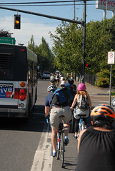
N/NE Portland could bring a cycle
track to N. Williams.
(Photo © J. Maus)
Metro has selected four active transportation projects to include in a grant application for possible funding through the U.S. Department of Transportation’s $1.5 billion Transportation Investments Generating Economic Recovery (TIGER) program.
The four projects, with an estimated total cost of $97 million, where whittled down from 27 that Metro received during a recent call for projects that went out to jurisdictions, agencies, and non-profit groups throughout the Portland region.
As we reported back in July, Metro decided to submit only non-motorized projects in their TIGER grant application and they wanted projects from each of three categories: “urban”, “suburban”, and “urban to nature”.
Here are the four projects, along with estimated costs, our comments, and a brief description from Metro:
Urban: North/Northeast Portland
Estimated cost: $38 million
Develop a complete bikeway network with innovative international best practices. This demonstration project will show how to take bicycle transportation in America to the “next level.” … This project will implement 54.7 miles of planned bikeways… This project will saturate the area with active transportation infrastructure similar to that found in the world’s best bicycling and pedestrian cities.
This is very exciting project that was submitted to Metro by Roger Geller at the City of Portland’s Bureau of Transportation. Geller has been a proponent of this concept (pouring big money into bike infrastructure to show the country/world what is possible in America) for a long time and this TIGER program might be just the opportunity to finally make it happen. The goal of this project is to reach a bike mode share of 35% in the target area.
From a draft document detailing this project, we’ve learned that the 54 miles of new bikeways would include 10 miles of cycle tracks, 10 miles of bike lanes, and “a world-class bikeway every 750 feet” (although keep in mind that Metro might have altered the project prior to submitting the final application). Below is a draft map outlining the project’s boundaries and potential new facilities:
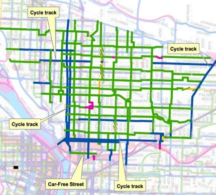
— Enlarge this map (PLEASE NOTE: Map is outdated and some projects shown did not make it through to final application. We’ll try to upload most recent map asap.) —
Suburban: Hillsboro – Access to high tech employment
Estimated cost: $ 21 million
The project is designed to alleviate barriers to bicycle and pedestrian access to light rail stations and key large employment sites. Highlighting the importance of linking bicycling and transit in low density areas, the City of Hillsboro’s package of strategic investments will help demonstrate that American suburbs can indeed be retrofitted toward active transportation integrated into daily life. The project will link areas of housing to employment centers, with direct, accessible, comfortable, enjoyable, and safe bicycle and pedestrian connections to existing light rail stations. The new active transportation connection will facilitate local travel and accommodate commute trips entering or leaving the Hillsboro community on High Capacity Transit.
Suburban: Milwaukie/Clackamas County – Access to industrial employment and new light rail
Estimated cost: $ 21 million
This project will demonstrate a forwarding thinking approach to improving multimodal conditions. This project is directly tied to the opening of a new light rail line. The proposed improvements will provide ‘last mile’ access to thousands of industrial jobs. Completion of pedestrian and bicycle infrastructure in this area would be a significant improvement in providing travel options such as walking and biking to work; alternatives that are simply not available today.
In both of the “Suburban” projects above, Metro’s Executive Council on Active Transportation is actively building coalitions with corporations (like Intel in Hillsboro) and business leaders that will directly benefit from these projects. The hope is to identify and work with project champions from the private sector that can help lobby for the projects and spread awareness about their importance to the region’s economy.
Urban to Nature: The Cazadero Trail from Boring to Estacada
Estimated cost: $17 million
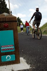
Springwater to the foot of Mt. Hood.
Allow inner city residents to access natural areas without the use of an automobile.
The Cazadero Trail is part of a larger long-term vision connecting Portland’s urban residents through the Mount Hood Connections (MHC) trail and greenway corridor. This corridor will provide a critical link between downtown Portland and the natural treasures found on the flanks of Oregon’s majestic icon, Mt. Hood. The vision for the corridor is to link Portland’s 21-mile long urban Springwater Trail system with trails that run along salmon-rich wild and scenic rivers, through old growth forests, to viewpoints that offer spectacular vistas of Mt. Hood and the surrounding National Forest. This project will finish the Springwater-Cazadero trail connection from Portland to the Clackamas River in the City of Estacada, the beginning of the West Cascades Scenic Byway.
All four of these projects represent an exciting new era for active transportation in our region. Metro continues to put major resources into non-motorized transportation and the important coalition building based around their Executive Council is evolving very quickly (more on that later).
The US DOT will make grant award decisions in February 2010 and projects selected must be completed by February 2012.


Here’s to the Cazadero Trail! It would be great to have that trail in place by 2012!
Jonathan, can these decisions be influenced by public input? Or is this a completely closed process?
This is great news for bike riders citywide, though why does this proposal for North Portland end at/ near Lombard?
Is there another district north of North Portland (Far North Portland – or Far South Vancouver) that includes Kenton/ Delta Park that I do not know about (from a planning perspective)?
Historically it seems that this area is underserved by PBoTs bike program. IMTO.
Sounds like a fantastic mix of projects! I would happily tax myself to pay for the proposed N/NE Portland bikeways project continued throughout the rest of the city. To think, for 1/2 the price of an urban highway interchange could have such dramatic positive effects on an urban landscape! I’m staring at the car-free street and bike-only path across the 12th ave bridge over I-84 – can’t wait!!!
Also great to see proposal to use bike infrastructure to extend the reach of the regional rail system.
The Milwaukie/Clackamas section seems pretty short on details. Does Metro give any specific projects for this area?
Wow. That N/ NE map is amazing! Any chance there is a place that I can zoom in on that map?
It looks like Holman, Emerson, Durham, 9th, 15th, 28th???
Hi Gregg, Just added a link so you can see a larger version of the map (about 700 pixels wide) — Jonathan
All those bikers in the photo are in the bus driver’s blind spot. Roadkill bait.
All of the projects submitted to Metro can be found at this link:
http://www.oregonmetro.gov/index.cfm/go/by.web/id=31205
The four selected are included in the list, but under somewhat different names as shown here. The Milwaukie/Clackamas project is listed as “Jennifer Ave. Industrial Corridor AT Connections.”
So… is the unpaved section of the Springwater paved now all the way to Boring? Last time I was out that way it wasn’t paved and was pretty hard to ride with skinny tires. More suited to knobbies. I believe it stopped being paved around where it crosses Telford St.
All the maps I’ve seen also show there is an unpaved gap into Boring (just looked last week). Are they going to pave that section in addition to the new trail? I’d love to ride from downtown Portland the whole length of the Springwater/Cazadero.
Sorry, I meant to say where it crosses 276th out in Gresham; Telford is further down towards Boring.
Kt: The TIGER grant funds described in this post will extend the trail from Boring eastward. Other funding (~$1.2 mil.) is anticipated to be received from ODOT to complete the paving from 276th (@ Rugg Rd.) to Boring.
Kt, yes that part of the springwater is still unpaved. But if you’re on a road bike take a left at 276, right on Telford and it will take you to Boring. There’s been talk of paving that section but I don’t know what the current plans are.
‘This project would take the
Springwater to the foot of Mt. Hood.’
Mt. Hood is only 50 miles from Portland. Imagine being able to cycle over there in a few hours! That would be the ultimate day trip by bike from Portland.
Oh that that reminds me..Summer is nearly over..when is it getting repaved East of 92nd? 🙂
I’m disappointed that the proposal for bikeways in northeast Portland stops at 72nd. Seems they ought to extend east at least as far 82nd, better yet to I-205.
re: Todd B/#2 and pdxeast/#13 yeah, I too was disappointed to see the map lacked most of the Peninsula north and west of Arbor Lodge (meaning St. Johns, Cathedral Park, Portsmouth, University Park, and Kenton) AND a big chunk of outer NE like Rose City Park, Roseway, Parkrose, Glenfair, Argay and several others…which are also traditionally “underserved.” Both have some pretty good plans on the table in the Master Plan, but I’m guessing the people putting this on the table feel that it would be harder to reach the 35% modeshare in these slightly farther out areas.
here’s a list of the proposed projects:
http://www.oregonmetro.gov/index.cfm/go/by.web/id=31205
What I’m REALLY sad about is that North Portland Greenway did not get selected. I think it fit well in both the Urban and Urban to Nature categories, as it would help extend some of the functions of the Eastbank Esplanade all the way to St. Johns. I’m hoping that Metro continues to look at ways to help & fund this project as well as the Sullivan’s Gulch project – both of which would serve as great connections from this inner portland “petri dish” to outer N and NE areas.
One of the constraints of the TIGER grant is that project work most be substantially completed by Feb. 2012. A project such as NP Greenway probably couldn’t be completed in that time frame. I’m sure that over time these proposals will be refined and that when future funding becomes available they will be more likely in a position to proceed.
The TIGER grants are national and will be very competitive. It is great that the region is offering something other than highway expansions and bridge repairs.
Esther,
the np greenway is high on everyone’s list… however since this is a stimulus grant program, the timeframes are very tight. It means that the projects must be far along in their technical planning stages and that they must be do-able and able to be completed in the next few years. the NPGreenway just isn’t quite that mature of a project yet.
rest assured, the NPGreenway and the Sullivan’s Gulch are both being talked about and acted upon at very high levels right now.
These changes look amazing! I live in the Concordia neighborhood, and it desperately needs some East/West bike lanes (glad to hear about Going). The only downside is the gentrification that is occurring due to all of the publicity that Portland is getting for its “bike-friendliness.” This attracts an exclusive, affluent, and very white demographic.
Not a reason to halt progress, but something to think about. Any thoughts?
Clearly, these are great projects that would do much to improve and increase bicycling in the Portland metro region. But to me, someone who grew up in a very different region (metro Detroit), it seems apparent that these plans have importance above and beyond their utility to Portlanders.
It may sound grandiose, but these are projects of national significance, and perhaps even global significance. If implemented, they will be looked to as models by cities across the United States and world. The Hillsboro and North Portland projects in particular have the potential to prove two very important points. The Hillsboro project can show that low-density postwar suburbs, the places where most Americans live, can be transformed to make them healthier, safer, more affordable, and more sustainable places to live. The North Portland project can show that older, more urban areas can be transformed in the same way, and that less affluent people can gain particular benefits from bicycle transportation.
Chris, you raise an interesting dilemma. North Portland was likely selected for broad-based bikeway implementation precisely because past bike facilities haven’t always reached Portland’s poorer neighborhoods, and because North Portlanders continue to suffer enormously from past transportation “investments” that were travesties of environmental justice. It was no coincidence that the nation’s black neighborhoods suffered the brunt of postwar urban freeway-building, which in Portland and elsewhere was often explicitly presented as a form of “slum clearance.”
Yet as you say, there’s a risk that this well-intentioned strategy could backfire. That’s because postwar development has not produced a large supply of truly healthy places to live, and even fewer places where it’s pleasant to bike. A lot of affluent people want to live in those places these days, though. As a result, making a neighborhood a better place to live, and making it more bikable, can increase its “market value,” price out current residents, and deprive them of the benefits they were supposed to realize.
So “gentrification-by-bikeway” is not entirely outside the realm of possibility, and there’s a certain chance that the bikeways may not ultimately reach all the people they’re intended to serve. In the end, though, I think we need to err on the side of making neighborhoods better places to live. The opposite logic would have us build more freeways to depress North Portland housing prices and make the area more affordable! That would be pretty absurd.
Also, thanks to projects like this one, we can expect many more neighborhoods in Portland and the country to get many more bikeways in future. That will make them all more desirable and reduce any tendency for white, affluent bicyclists to seek out this particular neighborhood above all others. Probably the most encouraging possibility these projects offer is the chance to spread the bicycle love beyond a small set of affluent whites, and make clear that this mode of transportation has something to offer everyone. It doesn’t just allow a cleaner environmental conscience, hipster street cred, and/or excellent physical form. Its virtues have much more universal appeal: convenience, health, and fun for practically free. And the world needs to know.
The twelve-lane Columbia River Crossing was classified as a “project of national significance.” Let’s hope USDOT sees that these modest little bikeway plans can ultimately have far greater significance – – and serve the greater good.