


The State of Oregon’s “Scenic Bikeway” program has taken a nice step forward. This week, the State’s Bicycle Recreation Coordinator, Alexandra Phillips, unveiled a website that features detailed maps and route information on the Willamette Valley Scenic Bikeway.
The Willamette Valley route is the first officially recognized scenic bikeway in the state and it’s referred to as “a prototype” for others yet to come. The 127-mile route begins at Champoeg State Heritage Area just south of Wilsonville and ends at Armitage County Park just north of Eugene.
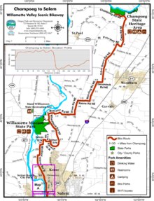
At the new website, riders can find printable maps and loads of information like places to camp, historic points of interest, elevation profiles and tips on side trips to take along the way. They’ve even broken the route down into four segments if you only have time for a one-day ride.
The effort to create a statewide network of scenic bikeways started well over a year ago and it’s being spearheaded by Phillips through the Oregon Parks and Recreation Department (OPRD).
The scenic bikeway concept originated with the folks behind Cycle Oregon (ride founder and former Oregonian columnist Jonathan Nicholas is a major proponent). Within the OPRD there is a Scenic Bikeway Committee that is working to designate more of the routes based on nominations made by the public.
Learn more about the Willamette Valley Scenic Bikeway at the official site of the Oregon Scenic Bikeways program… and start planning your ride today!