[Publisher’s note: This story was published yesterday on Page Two, but since it’s so darn beautiful outside right now, and because this is such a great resource, I thought it needed a bit more attention.]
River City Bicycles’ Rubber to the Road guidebooks have long been a popular way to learn about great rides in our region. Now the books have a useful, web-based complement at RubbertotheRoad.com.
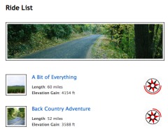
The website has a ton of great rides listed, complete with turn-by-turn directions and an interactive GPS-powered map. Here’s more about it from the latest River City Bicycles newsletter:
“…a free collection of exhilerating [sic] Portland-area rides put together by pro rider Jacob Erker. In addition to colorful descriptions and complete ride directions, you’ll have access to interactive maps powered by GPSies.com and GPS route files you can download to your GPS device.”
This is a fantastic resource. If you appreciate and/or use this site, River City reminds you that the entire project was done to help support the Bicycle Transportation Alliance and the Community Cycling Center.


This is really great. This should be a front page story, it’s great to have this tool.
There’s a page two???
This is really a very cool, useful, & well-done piece of work; hats off to Jacob for the time and effort he put in to assembling this.
just one quibble – well, not a quibble, really, just a recommendation for future site additions – the GPS maps are great for people who use GPS, i’m sure, but they’re not that great for the old school take-a-paper-map-along set. That would be me. Having printable PDFs for each ride with *large font* route street names, as well as cues by mileage, would be very helpful for us non-GPS-er’s.
If there’s a way to do this with the existing maps, someone give me a shout as to how & you can call me a nitwit at the same time.
And no, i do not intend to ever use GPS for riding, seems like it takes all the fun out of map decipherment.
thanks again, Jacob, for doing this!
Hey, that’s so cool. I love it! Tip O’hat to all those invoved. Thank you!
Appears to be an excellent resource! It’s now bookmarked.
There is also a ‘comment’ section after every ride so any changes or recommendations can be registered easily. Also, the non-GPS directions should be easy to follow. If this isn’t the case, I’d like to hear about it.
Thanks for riding!
David & Jacob, this is some amazing work, quite seamless to use, & the photos/descriptions are an elegant touch.
However, for my riding (always non-GPS) in unfamiliar areas I find it easiest to follow a clearly-labeled route map. Doesn’t seem like the map feature will allow you to print out a take-along map on 8.5 x 11 that shows the street labels. So, if you’re looking for more features to add (better known as more work to do), a single page route map (as a pdf) for each ride would be a great addition!
thanks for doing this – very cool!
I agree with the people asking for traditional maps. Many of us don’t own a GPS.
Also, it would be nice if there were more short routes listed. My ten year old daughter can handled 5-10 miles, but not the 18+ miles of most of the listed routes. I’d love to find some maps/routes for city biking for the family.
p.s. I also didn’t know there was a page 2. Why aren’t these articles incorporated into the standard RSS feed?
I’ll get working on the maps.
David, if it’s of any use as a model, here’s a sample of the PDF maps/cues I came up with a few year’s back for the City’s bike touring web info –
http://www.portlandonline.com/transportation/index.cfm?c=39900&a=93918
you’ll probably have to work at a somewhat smaller scale, to fit rides on a 8.5 x 11″ page.
Hey folks,
This is the best! I’ve been wanting to do a project like this for all my scads of GPS rides collected over the past two years, and i am really really really excited – thanks to the guys that put this together!
Just an interesting note: Miami-Dade managed to get a bike path from the burbs to town with help of an organization called Greenbeltways, helped by local biking groups, of course. Good example of what needs to be done everywhere.